Tourist attractions near Poganesti (Zam, Hunedoara county, Romania)
Photos of nearby places


Goat Stone - Craiva, Trascau Mountains (18 photos) 80.7 km away. Goat Stone (Piatra Craivii, Piatra Craivei, Apulon) - Craiva, Trascau Mountains.

Goats Ledge - Trascau Mountains (10 photos) 81.4 km away. Goats Ledge (Brana Caprei, Kecskék párkánya) - Trascau Mountains .

Stone of Cetea, Horse Pit - Trascau (16 photos) 82.2 km away. Stone of Cetea, Horse Pit (The pit cave from the Stone of Cetea) - Trascau Mountains.


Dark Blue Bruises of the Ponor - Trascau Mountains (16 photos) 84.3 km away. The Dark Blue Bruises of the Ponor (Vanatarile Ponorului) is a polje-type protected area. Polje is a Slovenian word meaning plain, and it refers to a surface karst form.

Valley of Hell - Padurea Craiului Mountains (23 photos) 84.7 km away. Valley of Hell (Valea Iadului) - Padurea Craiului Mountains.

Kings Cave - Padurea Craiului Mountains (48 photos) 85.7 km away. Craiului (Kings) Cave - Padurea Craiului Mountains.

Dark Blue Bruises of the Ponor, Bedeleu (24 photos) 86 km away. Dark Blue Bruises of the Ponor (Vanatarile Ponorului), Bedeleu - Trascau Mountains.

Balcony Clearing - Trascau Mountains (6 photos) 86.4 km away. Balcony Clearing (Erkély-tisztás, Balconul Sipotelor) - Trascau Mountains.

Fern Cave - Padurea Craiului Mountains (9 photos) 87.3 km away. Ferigi (Fern) Cave - Padurea Craiului Mountains.

Aries valley - Trascau Mountains (10 photos) 87.3 km away. Aries (Golden) valley - Trascau Mountains.

Sohodol pit cave - Padurea Craiului Mountains (10 photos) 89.9 km away. Sohodol pit cave (Avenul Sohodol) - Padurea Craiului Mountains.

Natural bridge next to the Banita Stone Quarry (12 photos) 92.4 km away. Although the Banita Stone Bridge is not far from the road that passes through the village, it is located beyond the railway line, so its approach is a bit cumbersome. We can go around the railway line on Carierei Street, and then we have to walk a few meters from the stone quarry.

Moanei Cave - Padurea Craiului Mountains (58 photos) 93.5 km away. The Moanei Cave (Pestera Moanei) is located on the upper course of the Misid River, on the right side of the Misid Gorge (Cheilor Misidului). The cave has two entrances, one fossil and sloped, while a subterranean stream flows through the active gallery.

Oxen Waterfall - Padurea Craiului Mountains (12 photos) 94.6 km away. Oxen Waterfall (Cascada Boilor) - Padurea Craiului Mountains.

Banita Gorge - Banita (16 photos) 94.7 km away. The approximately 250 m long gorge, similar to the Corcoaia Gorge, is truly spectacular. According to assumptions, it was formed by the collapse of a cave passage ceiling, and then the erosion formed spectacular karst formations in the limestone.

Boli Cave - Banita (20 photos) 94.8 km away. The main cave passage is approximately 460 m long, with an entrance portal that is 10 m high and 20 m wide at its base. In the 1960s, bridges were built over the underground stream flowing through the cave.
[ Top ↑ ]
Videos of nearby places

Pisoaia waterfall - Vidra 46.4 km away. Pisoaia waterfall (Pisoaia Vidrii, Urine of the otter) - Nemesi, Vidra.

Black Rocks iron path - Bihor Mountains 52.4 km away. Black Rocks is located in the Bihor Mountains, near the Vartop Saddle, to the west of it. It is interesting that the locals (if I understood correctly) do not know this name, but use the name Piatra Buna (meaning Good Stone) for this spectacular rock.


Meziad cave - Padurea Craiului Mountains 78.1 km away. The Meziad Cave is located near the village of Meziad, 22 km north of Beius, in the Padurea Craiului Mountains. It is one of our first tourist caves, its exploration is associated with the name of Gyula Czárán, cave researcher and writer.
Other places
Natural stone bridge Aglen 350.6 km away. Natural stone arch on the Vit river, near the village of Aglen. Crocodile shaped rock, Elephant rock.
Lonely Stone Hasmas Mountains 267.3 km away. On June 1, 2003, with a small group of friends, I left Balan, walking along the valley of the Sep (Beautiful) stream towards the Lonely Stone (Piatra Singuratica). Those who were with me at the time fell behind, and then other people joined for the hike.

The Wooden Ladders The villages of Scarisoara and Inelet, Cerna valley 116.4 km away. Scarisoara and Inelet are small, isolated villages located in the mountainous region of Banat. They are situated on the right bank of the Cerna River, approximately 19 km away from the Baile Herculane resort.
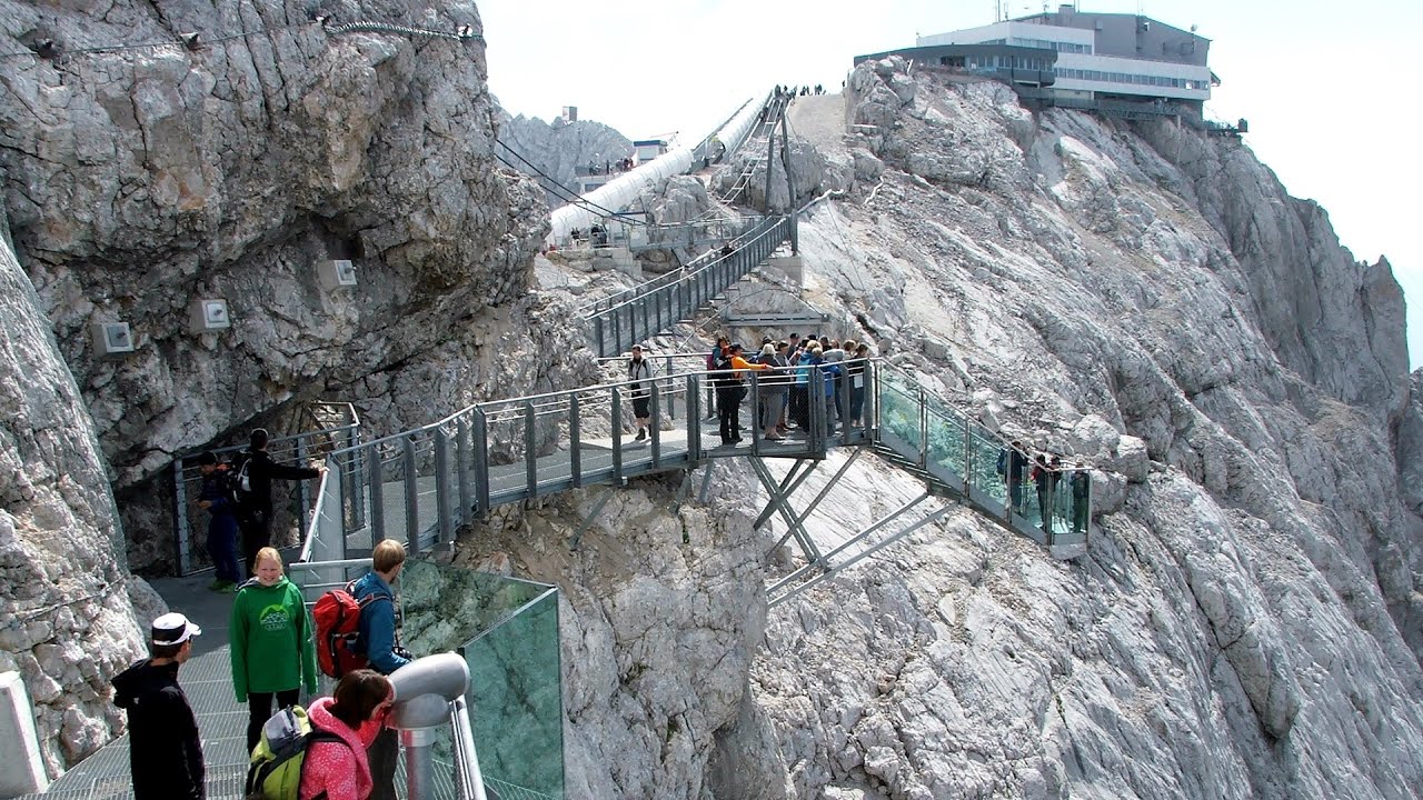
Sky Walk, Suspension Bridge, Stairway to Nothingness Styria, Dachstein The Dachstein cable car (Gletscherbahn Panorama Gondel, Panorama Cable Car) took me up to a height of 2700 meters, to the highest mountain in Styria (Steiermark), the Dachstein. Next to the upper station of the cable car there are several tourist attractions.
Devils Mill Gorge Campulung Moldovenesc 286.9 km away. The Devil's Mill Gorge is relatively short, measuring only 60 to 70 meters in length. It was formed in yellowish-gray-white dolomite by the work of a stream that crosses the gorge, as a result of erosion and the dissolution characteristic of limestone.
Mine lake Megyer mountain, Sárospatak 264 km away. The via ferrata routes of the Megyer mountain mine lake. The geologists' path E 25 m, Szabó József-memorial path C 200 m, Amphitheater D 40 m, Devil's Cauldron E 70 m, Sweet aquatic life D 150 m, Velociraptor C 35 m.

Fortress Kariya and the Lighthouse on Cape Shabla Shabla's lighthouse marks the easternmost point of Bulgaria. With its 32-meter height, it is the oldest and tallest lighthouse on the Black Sea.

The Heart of Jesus look-out Lupeni 218.2 km away. Through the mud on Gordon Mountain, above Farkaslaka (Lupeni commune, Harghita county, Transilvania), on a cloudy afternoon, at the end of February. The destination is the Heart of Jesus lookout, nicknamed as Pléhkrisztus (The Tin Christ).
White Drin waterfall 407.1 km away. Drini i Bardhe (White Drin) waterfall.
[ Top ↑ ]
Copyright © 2003-2026 Trekkingklub and friends. Reproduction of any text, picture or video from this website, either in printed or electronic form, is prohibited without prior written permission. Website made with love  in Miercurea Ciuc.