Tourist attractions near Sacosu Mare (Darova, Timis county, Romania)
Photos of nearby places

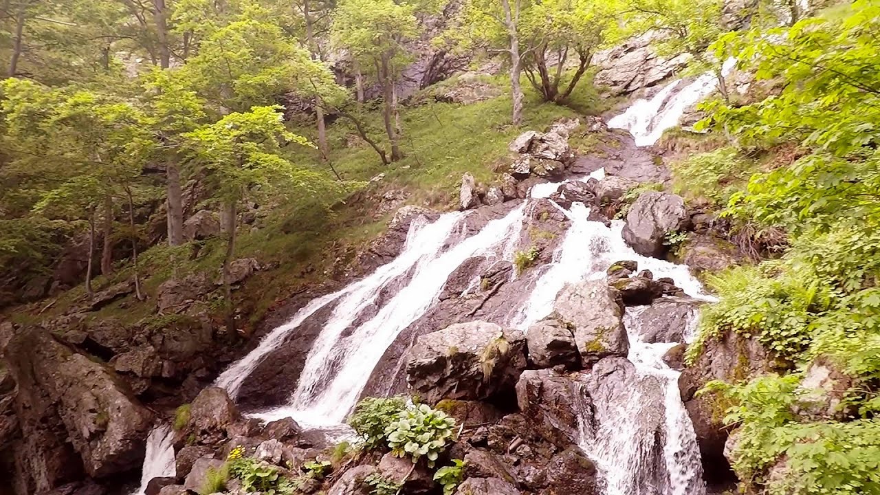
Beusnita waterfall (8 photos) 72.5 km away. Cascada Beusnita, located in the Caras-Severin county, is one of the most impressive waterfalls in the Anina Mountains. The water falling from a height of approximately 15 m, into a clearing in the middle of the forest, creates a uniquely picturesque landscape.


Natural bridge next to the Banita Stone Quarry (12 photos) 120.4 km away. Although the Banita Stone Bridge is not far from the road that passes through the village, it is located beyond the railway line, so its approach is a bit cumbersome. We can go around the railway line on Carierei Street, and then we have to walk a few meters from the stone quarry.


Banita Gorge - Banita (16 photos) 124.1 km away. The approximately 250 m long gorge, similar to the Corcoaia Gorge, is truly spectacular. According to assumptions, it was formed by the collapse of a cave passage ceiling, and then the erosion formed spectacular karst formations in the limestone.

Boli Cave - Banita (20 photos) 124.7 km away. The main cave passage is approximately 460 m long, with an entrance portal that is 10 m high and 20 m wide at its base. In the 1960s, bridges were built over the underground stream flowing through the cave.


Parangul Mare peak (16 photos) 143.7 km away. Chamois saddle (Saua Caprelor), Carja mountain shelter (Refugiul Carja) - Carja peak (Varful Carja) - Stoienita peak (Varful Stoienita) - Gemanarea - Parangul Mare peak.

Kings Cave - Padurea Craiului Mountains (48 photos) 149.7 km away. Craiului (Kings) Cave - Padurea Craiului Mountains.

Valley of Hell - Padurea Craiului Mountains (23 photos) 151.9 km away. Valley of Hell (Valea Iadului) - Padurea Craiului Mountains.

Fern Cave - Padurea Craiului Mountains (9 photos) 152 km away. Ferigi (Fern) Cave - Padurea Craiului Mountains.

Goat Stone - Craiva, Trascau Mountains (18 photos) 152.6 km away. Goat Stone (Piatra Craivii, Piatra Craivei, Apulon) - Craiva, Trascau Mountains.

Sohodol pit cave - Padurea Craiului Mountains (10 photos) 153.1 km away. Sohodol pit cave (Avenul Sohodol) - Padurea Craiului Mountains.


Stone of Cetea, Horse Pit - Trascau (16 photos) 155.5 km away. Stone of Cetea, Horse Pit (The pit cave from the Stone of Cetea) - Trascau Mountains.

Goats Ledge - Trascau Mountains (10 photos) 155.5 km away. Goats Ledge (Brana Caprei, Kecskék párkánya) - Trascau Mountains .

Moanei Cave - Padurea Craiului Mountains (58 photos) 158.5 km away. The Moanei Cave (Pestera Moanei) is located on the upper course of the Misid River, on the right side of the Misid Gorge (Cheilor Misidului). The cave has two entrances, one fossil and sloped, while a subterranean stream flows through the active gallery.

Dark Blue Bruises of the Ponor - Trascau Mountains (16 photos) 159.7 km away. The Dark Blue Bruises of the Ponor (Vanatarile Ponorului) is a polje-type protected area. Polje is a Slovenian word meaning plain, and it refers to a surface karst form.

Dark Blue Bruises of the Ponor, Bedeleu (24 photos) 161.7 km away. Dark Blue Bruises of the Ponor (Vanatarile Ponorului), Bedeleu - Trascau Mountains.
[ Top ↑ ]
Videos of nearby places

Rudariei watermills - Eftimie Murgu 84.8 km away. I have visited the twenty-two wooden water mills with horizontal wheels, located in the valley of the Rudaria stream, mostly in the rain and under an umbrella. Some of them are still in use today.

The Wooden Ladders - The villages of Scarisoara and Inelet, Cerna valley 90 km away. Scarisoara and Inelet are small, isolated villages located in the mountainous region of Banat. They are situated on the right bank of the Cerna River, approximately 19 km away from the Baile Herculane resort.

Blasted Rock hanging path - Cerna Valley 90.1 km away. The Blasted Rock (Piatra Puscata) hanging path is located on the geographical right bank of the Cerna River, near the confluence of the Iuta stream, approximately 20 km from Baile Herculane. In this area, the presence of limestone formations has caused the valley to become narrower.

Corcoaia Gorge - Gorj county 90.5 km away. The Corcoaia Gorge is one of the most beautiful tourist attractions in the Cerna Valley. It can be reached by car, 43 km away from Baile Herculane, of which about 17 km is on a dusty gravel road.

Mill of the Devils - Tasna Gorge 92 km away. Mill of the Devils (Moara Dracilor) - Tasna Gorge (Cheile Tasnei). The Tasna Gorges are located in the Mehedinti Mountains, approximately 15 km from the resort of Baile Herculane.
Other places
Abandoned Sports Hall Varna An abandoned sports hall in Varna, with an unfinished dormitory and tennis courts across three levels.
Abandoned copper mine Tsar Asen, Pazardzhik 415.1 km away. The turquoise waters of this mine lake are extremely beautiful but dangerously poisonous. Do not descend to the shore or touch the water!
Falco Peregrinus 2 via ferrata Falcons Rock, Corbu 344.2 km away. Falco Peregrinus (Peregrine falcon) 2 via ferrata (D) - Falcon's Rock, Corbu.


Pisoaia waterfall Vidra 123.8 km away. Pisoaia waterfall (Pisoaia Vidrii, Urine of the otter) - Nemesi, Vidra.
Babsko Praskalo waterfall Tazha 415.6 km away. In the Central Balkans National Park, there are many rivers that cascade down spectacular waterfalls, which the locals call praskalo. One of the smallest waterfalls in the area is Babsko Praskalo, which stands at only 54 meters high.

Hias via ferrata Silberkarklamm, Ramsau am Dachstein The Hias via ferrata in the Silberkar Gorge (Silberkarklamm) is the first of the three via ferrata routes, and perhaps the easiest to complete. Two cable bridges and a few trickier sections make it interesting, but it is truly impressive due to the view of the narrow gorge.
Lonely Stone Hasmas Mountains 338.4 km away. On June 1, 2003, with a small group of friends, I left Balan, walking along the valley of the Sep (Beautiful) stream towards the Lonely Stone (Piatra Singuratica). Those who were with me at the time fell behind, and then other people joined for the hike.
Rossloch Klettersteig Leopoldsteiner See The D/E difficulty Rossloch via ferrata is situated at the top of the 900-meter-high Seemauer cliff, overlooking the Leopoldsteiner See in the western part of the Hochschwab mountain range. It is designed for experienced via ferrata climbers, and complements the already impressive Emperor Franz Joseph via ferrata, as the two routes can be connected.
Other destinations
Gornjak via ferrata and Kudelinovs fortress Zdrelo 146.5 km away. Difficulty level C/D, total length: 400 m, height difference: 330 m, year of construction: 2019, total length of the route to Kudelinov's fortress: 1100 m. Access to the via ferrata is free.
[ Top ↑ ]
Copyright © 2003-2026 Trekkingklub and friends. Reproduction of any text, picture or video from this website, either in printed or electronic form, is prohibited without prior written permission. Website made with love  in Miercurea Ciuc.