Cotton Sinkhole hanging library | Video
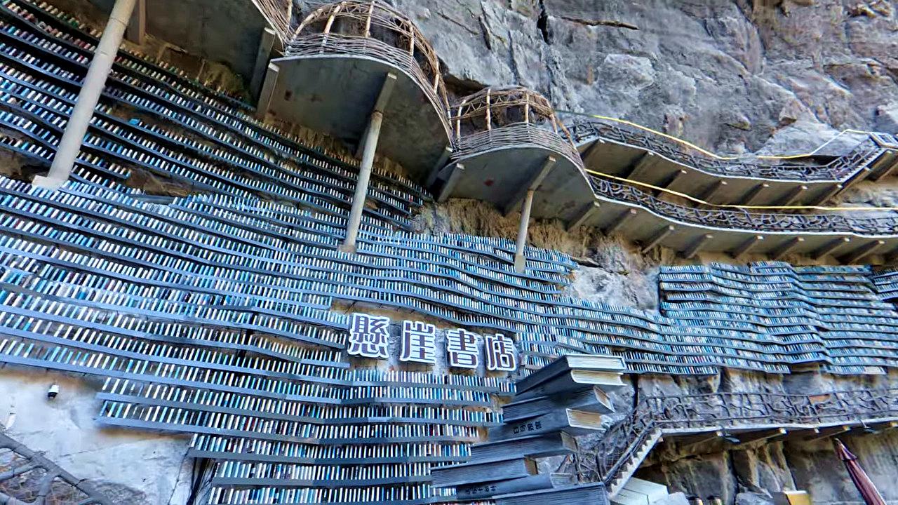
Cotton Sinkhole (Mianhua tian keng) hanging library - Luocheng Mulao Autonomous County, Hechi city, Guangxi Zhuang Autonomous Region. Inside of this large grotto, the Cotton Sinkhole, there is a unique library hanging on the side of the rock wall, with rock-hanging wooden walkways and balconies.
Login (register) for the full descriptions, and access to the photos and videos.
Airport nearby Hechi Jinchengjiang Airport (HCJ - Hechi (Jinchengjiang), Cn), 109 km away from Cotton Sinkhole hanging library.
Photos of nearby places

Pricopanului ridge - Macin Mountains (61 photos) Pricopanului ridge is the secondary, but imposing ridge of Macin Mountains, characterized by huge granite formations, lofty rocks and wide sceneries all around. The landscape, as well as the relief is of mountain type, and even if the height of the ridge is apparently small, the ascending effort is slighty sustained.

Fortress Kariya and the Lighthouse on Cape Shabla (0 photos) Shabla's lighthouse marks the easternmost point of Bulgaria. With its 32-meter height, it is the oldest and tallest lighthouse on the Black Sea.

Stone Sea and Little Sea beach - Shabla (10 photos) Monument of fallen Soviet aviators (May 17, 1944), Stone Sea and Little Sea beach - Shabla.

Bird Observatory at Shabla Tuzla Lake (11 photos) Three coastal lakes - Shabla, Ezerets, and Shabla Tuzla - support a great variety of plants and animals. The lakes are especially important in winter, and they are protected to provide a refuge for their unique wildlife.

Ezerets beach - Shabla, Dobrich (10 photos) The beach near the village of Ezerets is semi-wild, relatively quiet and clean, without sunbeds or umbrellas. The sand is fine-grained, and the water is clear.

The coast of the Black Sea north of Tyulonovo (36 photos) The Portal, the Salt Pools, the Wild Frog's Point, the Seal Cave, the Passage and the Whale.

Fishermens harbor - Tyulenovo (14 photos) Tyulenovo church, Monument to Lieutenant Valentin Terziev, Fishermen's harbor. Tyulenovo translates to Village of Seals in Bulgarian, although seals have not been observed in the area since the 1980s.

Tyulenovo Cliffs and the Rock Arch (23 photos) The coast of Tyulenovo consists of a complex of sheer reefs, steep sea cliffs, and natural and artificial sea caves. There are picturesque beaches and rocky coasts, along with adjacent marine areas, both north and south of Tyulenovo.

The coast of the Black Sea south of Tyulenovo (10 photos) The coast of the Black Sea south of Tyulenovo.

The cave with the metal ladder - Tyulenovo (27 photos) The cave with the metal ladder (Peshterata s metalnata stalba) - Tyulenovo.


The Gate of the 40 Virgins (12 photos) The Gate of the 40 Virgins, The monument to Admiral Ushakov on Cape Kaliakra.


Round rocks from Viisoara - Berzunti (12 photos) Round rocks are quite a common curiosity, apart from those in Costesti, Valcea county, there are numerous other locations with similar rock formations. The round rocks from Viisoara are located northwest of the village, at a distance of approximately 700 meters from DC152 road.

Smooth Cliffs - Rezovo (12 photos) Smooth Cliffs (Smooth Rocks, Gladkite Skali) - Rezovo. Uniquely polished and smooth, these rocks near Rezovo stand out among the rough, sharp-edged rock formations along Bulgaria's Black Sea coast.

The rocky coast of the Black Sea - Rezovo (23 photos) The coast of Rezovo village, which includes the Smooth Rocks (Gladkite Skali) and the Old Pier (Stariat Kei), is one of the most stunning rocky coastlines along Bulgaria's Black Sea coast.

The Old Pier - Rezovo (16 photos) The Old Pier (Stariat_Kei) is a historic structure that has served as a point for fishing and transportation. Today, it is a destination for visitors seeking tranquility, beautiful natural surroundings, and picturesque sea views.

Rezovo, Bulgarias Southeasternmost Coastal Village (14 photos) Located in southeastern Bulgaria on the Bulgaria-Turkey border, Rezovo is a picturesque seaside village and resort at the southernmost tip of the Bulgarian Black Sea Coast. It is notable for its position overlooking the Turkish bank of the Rezovo River.


Stone bathtub - Small Kastrich Beach (10 photos) Stone bathtub (Kamenna Vana) - Small Kastrich Beach (Plazh malak Kastrich).


The Rock Gate and the Red Bay - Rezovo (8 photos) The Rock Gate (Skalnata porta) and the Red Bay (Cherveniat zaliv) are located at the southeastern end of Silistar Beach. Here, two massive rock formations rise from the water, forming a gate.
[ Top ↑ ]
Videos of nearby places
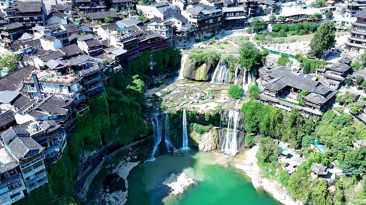
Furong Waterfall - Furong ancient town 454.5 km away. Furong waterfall, Tujia ancestors' cave relics, Tusi palace, Wuli slate street, Tuwang bridge, Xizhou copper pillar. From Zhangjiajie West Railway Station, take the high-speed train to Furong Town Railway Station, 25 minutes.
Balcony of Nostalgia Waterfall - Simian Mountain 486.3 km away. Balcony of Nostalgia (Wangxiangtai) Waterfall - Simian Mountain, Jiangjin District, Chongqing. The 150 m high and 40 m wide waterfall is the world's largest heart-shaped waterfall.
Sky Eye Qixing Mountain - Zhangjiajie 499.3 km away. Qixing (Seven Star) Mountain - Yongding district, Zhangjiajie prefecture-level city, Hunan province. Qixingshan open 8:30 - 16:00, entrance fee CNY239 (120) WeChat Zhangjiajie Qixing Mountain.
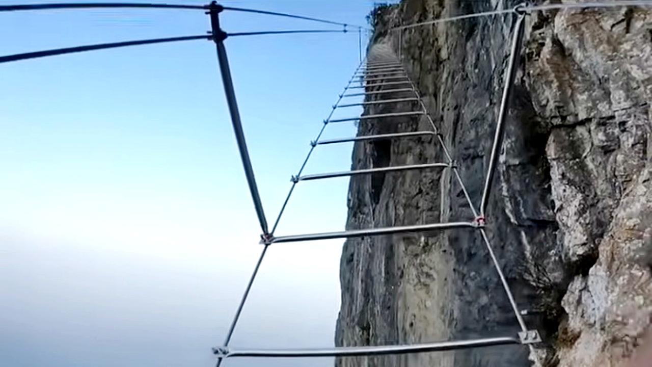
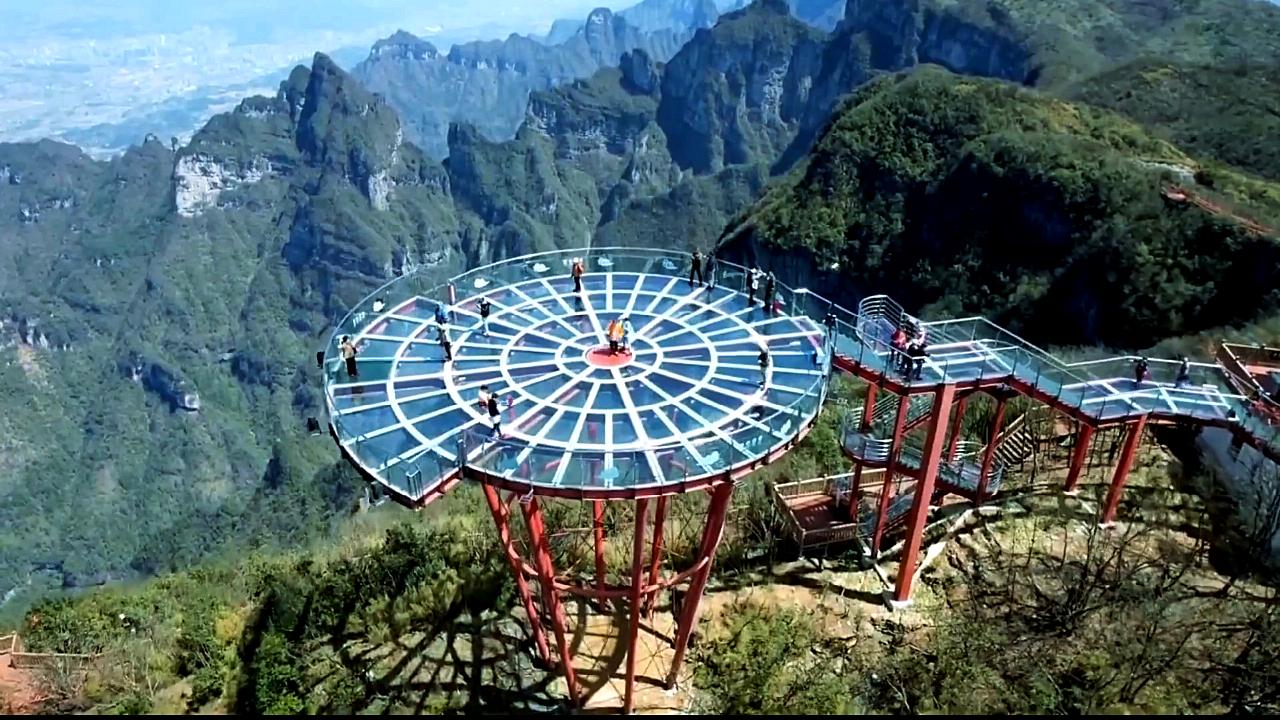
Qixing Mountain via ferrata - Zhangjiajie 499.4 km away. Qixing Mountain Via Ferrata and Sky Ladder. Yongding district, Zhangjiajie prefecture-level city, Hunan province.
Other places
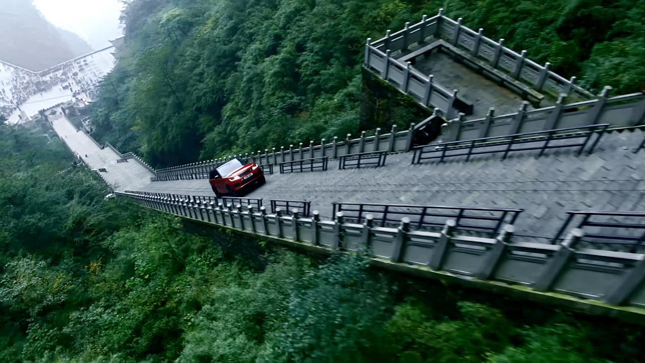
Dragon Challenge 2018 Heavens Gate, Tianmen Mountain The Range Rover Sport Plug-in Hybrid Dragon Challenge 2018. Heaven's Gate, Tianmen Mountain - 99 turns, 999 steps, 22 minutes and 41 seconds.
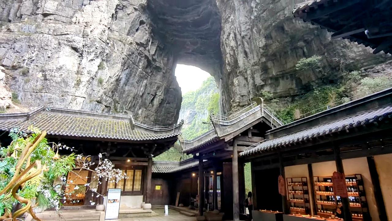
Three Natural Bridges West entrance - Three Natural Bridges scenic area. Wulong district, Chongqing municipality.
Qixing Mountain via ferrata Zhangjiajie 499.4 km away. Qixing Mountain Via Ferrata and Sky Ladder. Yongding district, Zhangjiajie prefecture-level city, Hunan province.
Furong Waterfall Furong ancient town 454.5 km away. Furong waterfall, Tujia ancestors' cave relics, Tusi palace, Wuli slate street, Tuwang bridge, Xizhou copper pillar. From Zhangjiajie West Railway Station, take the high-speed train to Furong Town Railway Station, 25 minutes.
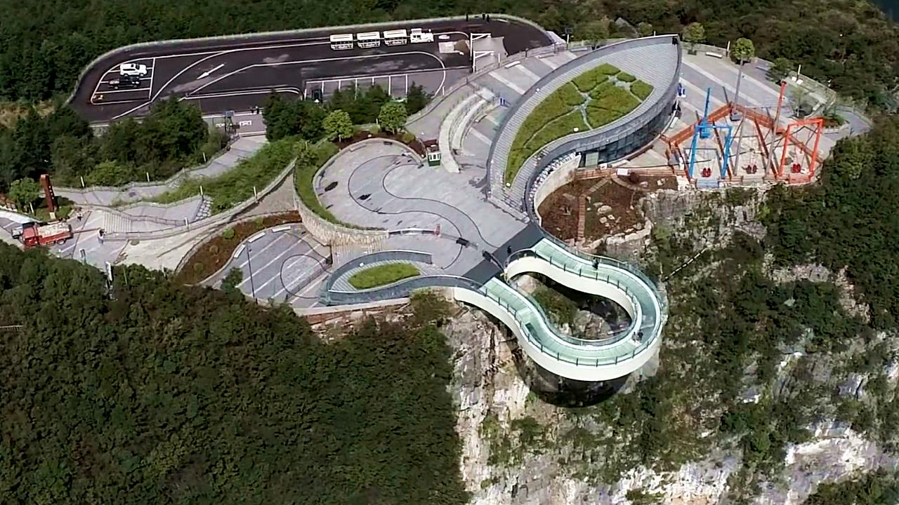
Cloud cantilever bridge Dragon Sinkhole Cloud cantilever bridge (Cloudwalk Sky Bridge) - Dragon Sinkhole (Longgang Tiankeng) scenic area, Yunyang county, Chongqing. The bridge, which has a cantilever structure, glass deck and railings, has a circumference of 60 m.
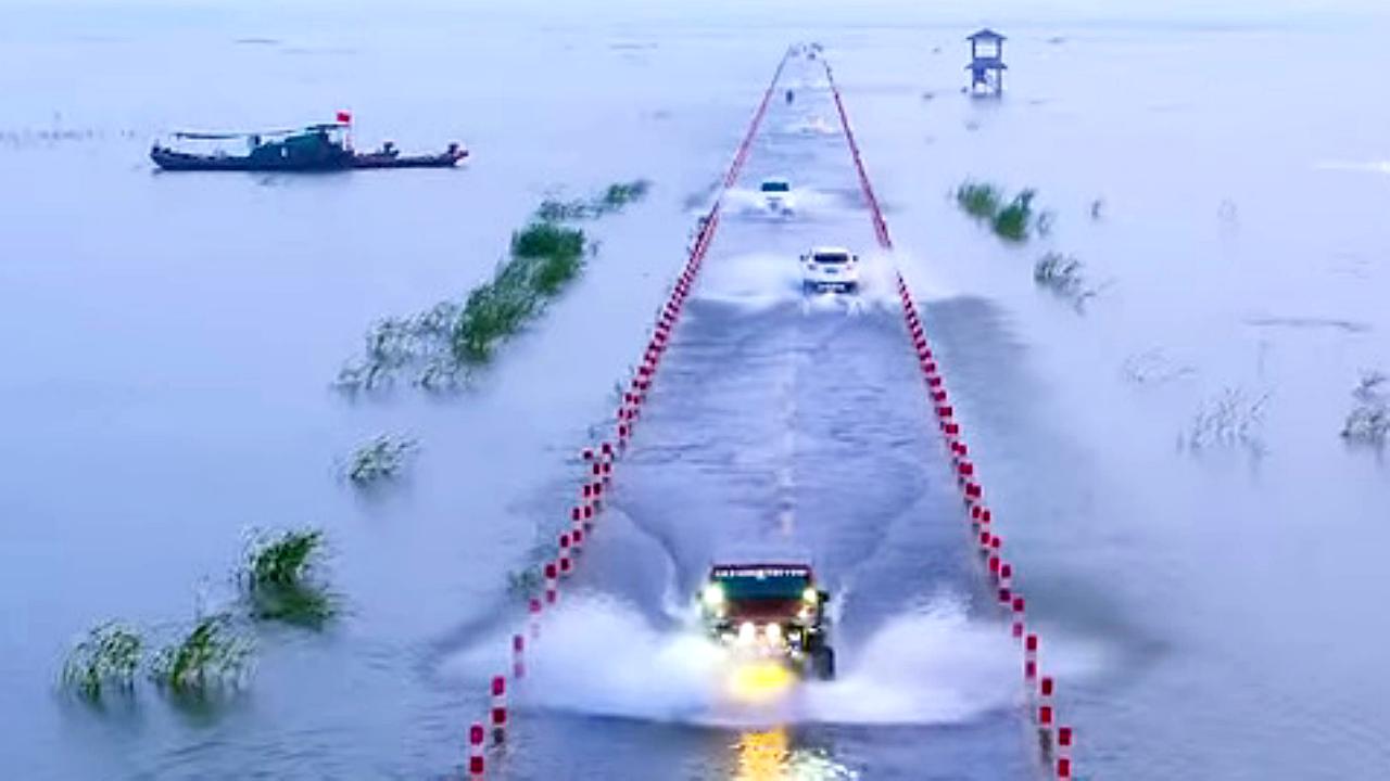
Yongwu flooded road Poyang lake The road under the water, Yongwu flooded road. Poyang lake, Wuchengzhen, Yongxiu county, Jiujiang, Jiangxi province.
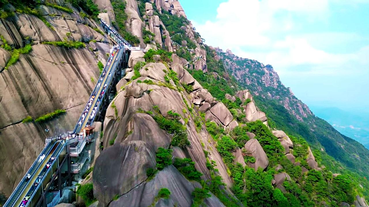
Ling Mountain Scenic Area Cloud Ladder escalator Guangxin district, Shangrao city, Jiangxi province. The Cloud Ladder is the world's longest cliffside escalator - length: 753 m; height: 267 m; duration: 30 minutes.
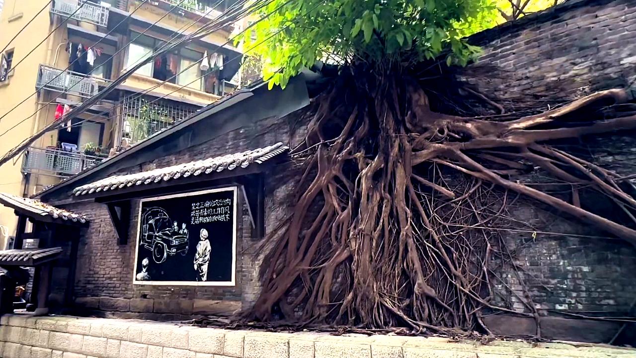
Daijiaxiang Cliff Trail Daijiaxiang Cliff Trail - Yuzhong District, Chongqing. Huangjue tree (Huangge tree, Ficus virens), the city tree of Chongqing.
[ Top ↑ ]
Copyright © 2003-2026 Trekkingklub and friends. Reproduction of any text, picture or video from the Cotton Sinkhole hanging library website, either in printed or electronic form, is prohibited without prior written permission.
The given distances are to be understood as straight line distances, and are approximate. Website made in Miercurea Ciuc  .
.