Play Wall via ferrata park - Mariazeller via ferrata, Felix's Ladder to the Heaven, Devil's Bridge | Video
Hiking photos and videos Login Register
Select language: - Magyar - Romana - Deutsch - Français - Italiano - Español -
Select language: - Magyar - Romana - Deutsch - Français - Italiano - Español -

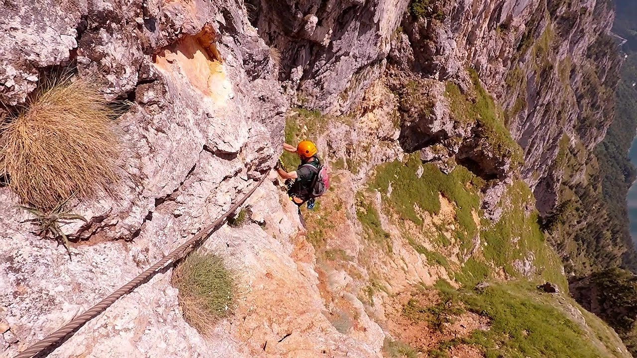
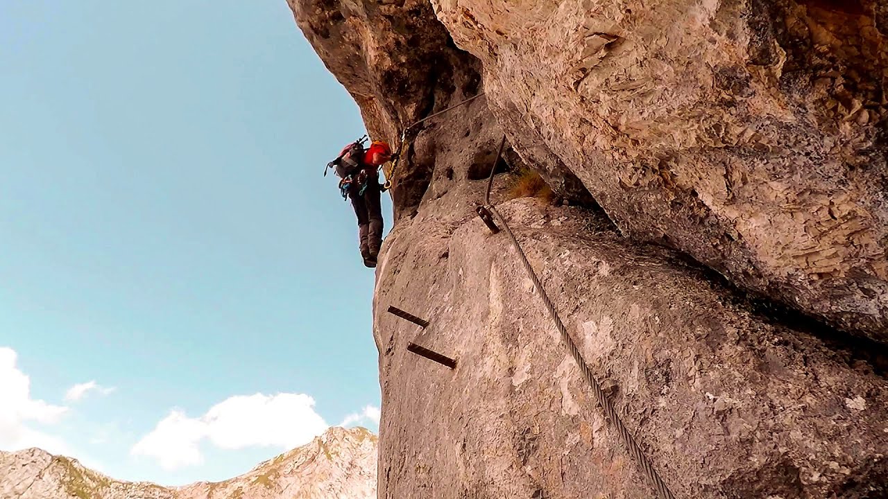
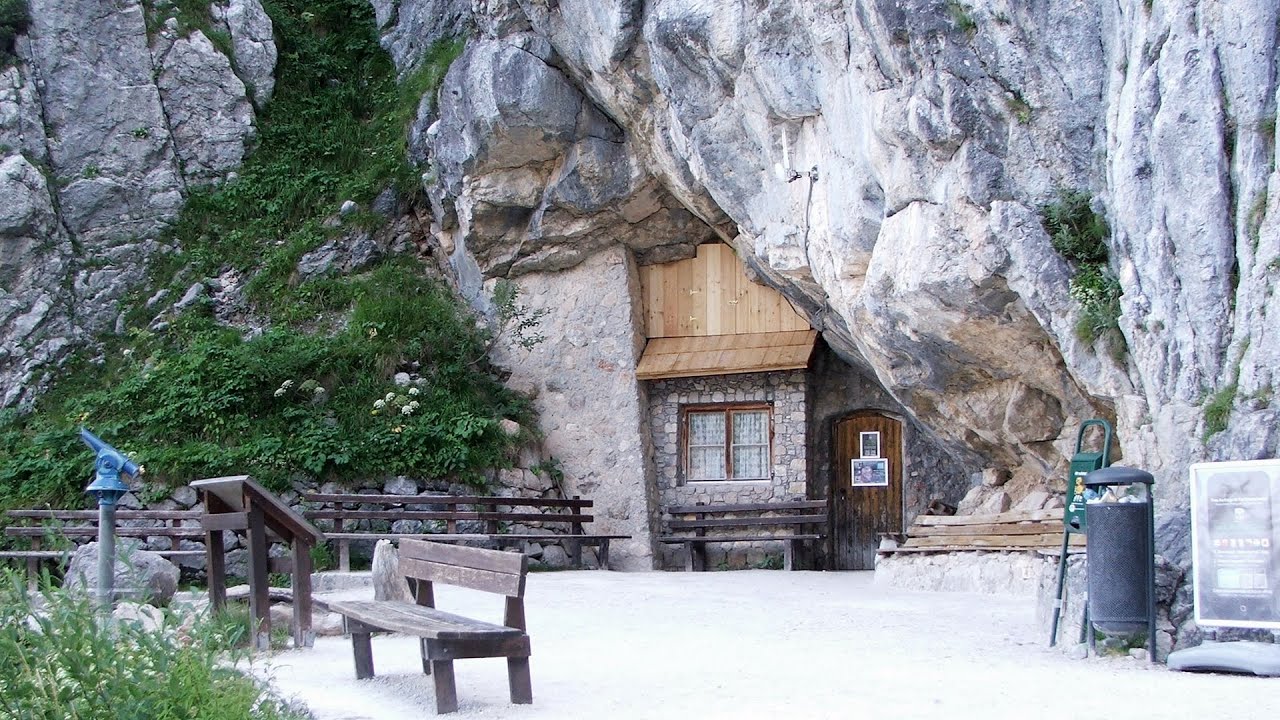
Located only ten kilometers from the town of Mariazell, you'll find the via ferrata park known as the Play Wall (Klettersteigpark Spielmäuer). Here, we find three via ferratas: Olivers Mariazeller Steig (B/C), Felix Himmelleiter (D), and Tristans Kirchbogensteig (C). In front of the Post Inn (Gasthof Post), there is a large parking lot available for our use.
Read more
Filmed with GoPro HERO5 Black. Music: No Promises No Guarantees by Alasdair Cooper. Copyright © 2017 - 2025 Geo Trekker Videos.
Already published 8983 photos and 180 videos. Please register for full and ad-free access.
Photos of nearby places

Mariazell climbing route, Felix's Celestial Ladder, Devil's Bridge - Climbing Park Spielmäuer (60 photos) 0 km away
Climbing Park Spielmäuer - Mariazell climbing route, Felix's Celestial Ladder, Devil's Bridge (Kletterpark Spielmäuer - Mariazeller Steig, Felix Himmelsleiter, Teufelsbrücke) - Wegscheid, Austria.

The Devil's Bridge (Teufelsbrücke) - Wegscheid, Austria (18 photos) 0.94 km away
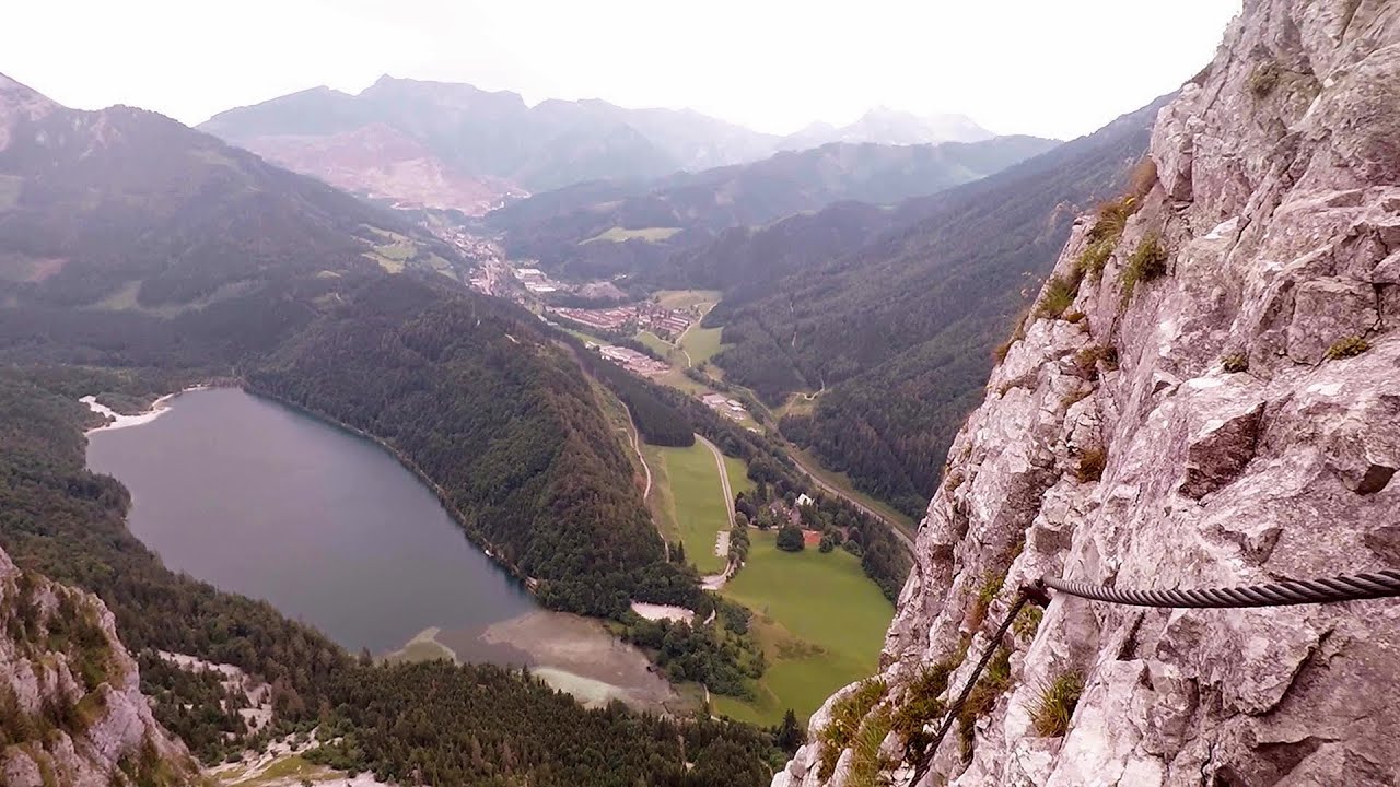
The Devil's Bridge, Teufelsbrücke in German, is located just ten kilometers from the city of Mariazell, near the Klettersteigpark Spielmäuer via ferrata park. From the top of the via ferrata park, it is worth taking a detour to the Devil's Bridge, which is located near the starting point of the descent path.

Lake Bohinj - Upper Carniola, Slovenia (10 photos) 190.84 km away
Lake Bohinj, also known as Bohinjsko jezero in Slovene and Wocheiner See in German, is the biggest permanent lake in Slovenia, covering a vast area of 318 hectares. Situated in the Bohinj Valley of the Julian Alps, in the northwestern region of Upper Carniola (Gorenjska, Alta Carniola, Oberkrain), it forms a part of the Triglav National Park.

Slap Savica waterfall - Slovenia (12 photos) 193.34 km away
Slap Savica, found in the northwestern part of Slovenia, is a magnificent, 78 m high waterfall. It derives its water from a karst spring called Savica located just above the falls.

Vogel Ski Resort - Slovenia (33 photos) 194.01 km away
Vogel Ski Resort is situated in Slovenia, above Bohinj and adjacent to Lake Bohinj, on the outskirts of Triglav National Park. The resort derives its name from the nearby Mount Vogel, and was established in 1964.

Kanin cableway and ski resort - Shooting window, Monte Forato, Bovec, Sella Nevea (48 photos) 203.44 km away
The Kanin Mountains are located in the Western Julian Alps, on the border of Slovenia and Italy. The highest peak in this range, known as (High) Kanin or Monte Canin Alto, in Slovenian and Italian respectively, reaches a height of 2,587 m above sea level.

Slap Kozjak waterfall - Slovenia (24 photos) 205.83 km away
Slap Kozjak waterfall, perhaps the most beautiful waterfall in Slovenia, is situated near Kobarid. Located within the Kozjak stream gorge, and overlooking the stunning emerald green Soca River, this magnificent waterfall cascades 15 meters high, and is enclosed within a mesmerizing stone chamber.

Boka Waterfall - Slovenia (11 photos) 206.19 km away
Boka (Slap Boka) is a waterfall in western Slovenia, near the Soca River. It has two stages, with the first being 106 m high and 18 m wide, and the second being 33 m high.
[ Top ↑ ]
Videos of nearby places
Leopoldsteiner lake - Eisenerz, Steiermark 36.88 km away
Leopoldsteiner See is located in Styria, 4 km northwest of the town of Eisenerz. It lies at an elevation of 628 meters above sea level in the western part of the Hochschwab mountain range, at the foot of the Seemauer cliff.
Rossloch Klettersteig - Leopoldsteiner See 37.01 km away
The D/E difficulty Rossloch via ferrata is situated at the top of the 900-meter-high Seemauer cliff, overlooking the Leopoldsteiner See in the western part of the Hochschwab mountain range. It is designed for experienced via ferrata climbers, and complements the already impressive Emperor Franz Joseph via ferrata, as the two routes can be connected.
Kaiser Franz-Josef Klettersteig - Leopoldsteiner See 37.29 km away
The Franz-Josef Klettersteig is located on the Seemauer cliff face, which rises 900 meters above Leopoldsteiner Lake, in the western part of the Hochschwab mountain range, just 4 km from the town of Eisenerz. This via ferrata is named after the Kaisersteig, a hunting trail established for the esteemed Emperor Franz Joseph I of Austria and Hungary at the end of the 19th century, traces of which can still be observed today.
Kaiserschild Klettersteig - Eisenerzer Ramsau 41 km away
The 2,085-meter-high Kaiserschild peak is situated on the northern edge of the Eisenerz Alps in Styria, Austria. It forms a double summit with the slightly taller Hochkogel peak, which stands at 2,105 meters.
Giant Ice Cave (Rieseneishöhle) - Dachstein Salzkammergut, Obertraun am Hallstättersee 121.25 km away
The second cave accessible to the public at the Schönbergalm above Obertraun on Lake Hallstatt is the Giant Ice Cave (Rieseneishöhle). For me, it was more spectacular than the Mammoth Cave.
Other places
Rosina via ferrata Silberkar Gorge, Ramsau am Dachstein 123.55 km away
The Rosina via ferrata is the most difficult via ferrata in the Silberkar Gorge (Silberkarklamm), has a D difficulty rating, and it is a vertical masterpiece. After a short suspension bridge above the stream, it leads up the rock wall next to the gorge waterfall, all the way vertically.
The Rosina via ferrata is the most difficult via ferrata in the Silberkar Gorge (Silberkarklamm), has a D difficulty rating, and it is a vertical masterpiece. After a short suspension bridge above the stream, it leads up the rock wall next to the gorge waterfall, all the way vertically.
Via ferrata Tatabánya 231.63 km away
I climbed Kata! Who is Kata?
I climbed Kata! Who is Kata?
Hias via ferrata Silberkarklamm, Ramsau am Dachstein 123.53 km away
The Hias via ferrata in the Silberkar Gorge (Silberkarklamm) is the first of the three via ferrata routes, and perhaps the easiest to complete. Two cable bridges and a few trickier sections make it interesting, but it is truly impressive due to the view of the narrow gorge.
The Hias via ferrata in the Silberkar Gorge (Silberkarklamm) is the first of the three via ferrata routes, and perhaps the easiest to complete. Two cable bridges and a few trickier sections make it interesting, but it is truly impressive due to the view of the narrow gorge.
Sky Walk, Suspension Bridge, Stairway to Nothingness Styria, Dachstein 129.49 km away
The Dachstein cable car (Gletscherbahn Panorama Gondel, Panorama Cable Car) took me up to a height of 2700 meters, to the highest mountain in Styria (Steiermark), the Dachstein. Next to the upper station of the cable car there are several tourist attractions.
The Dachstein cable car (Gletscherbahn Panorama Gondel, Panorama Cable Car) took me up to a height of 2700 meters, to the highest mountain in Styria (Steiermark), the Dachstein. Next to the upper station of the cable car there are several tourist attractions.
Five Fingers, World NATURE Heritage Lookout, World Heritage Spiral, Dachstein Shark 123.42 km away
The second station of the cable car departing from Obertraun is the Krippenstein peak (2100 m). Here you can find the famous Five Fingers (5fingers) lookout, which offers a unique view of Hallstatt and Obertraun below, as well as the Hallstättersee lake.
The second station of the cable car departing from Obertraun is the Krippenstein peak (2100 m). Here you can find the famous Five Fingers (5fingers) lookout, which offers a unique view of Hallstatt and Obertraun below, as well as the Hallstättersee lake.
[ Top ↑ ]
[ Top ↑ ]
Copyright © 2003-2025 Trekkingklub and friends. Reproduction of any text, picture or video from this website, either in printed or electronic form, is prohibited without prior written permission.
The given distances are to be understood as straight line distances, and are approximate. Website made in Miercurea Ciuc  .
.