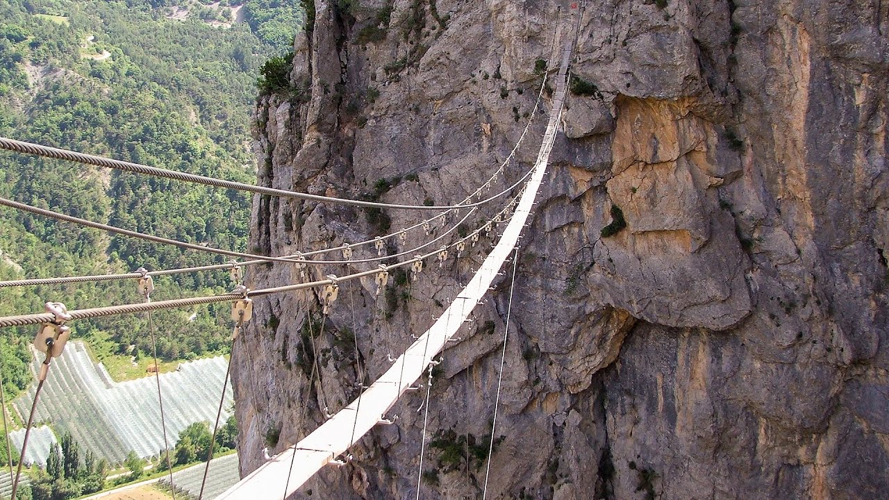
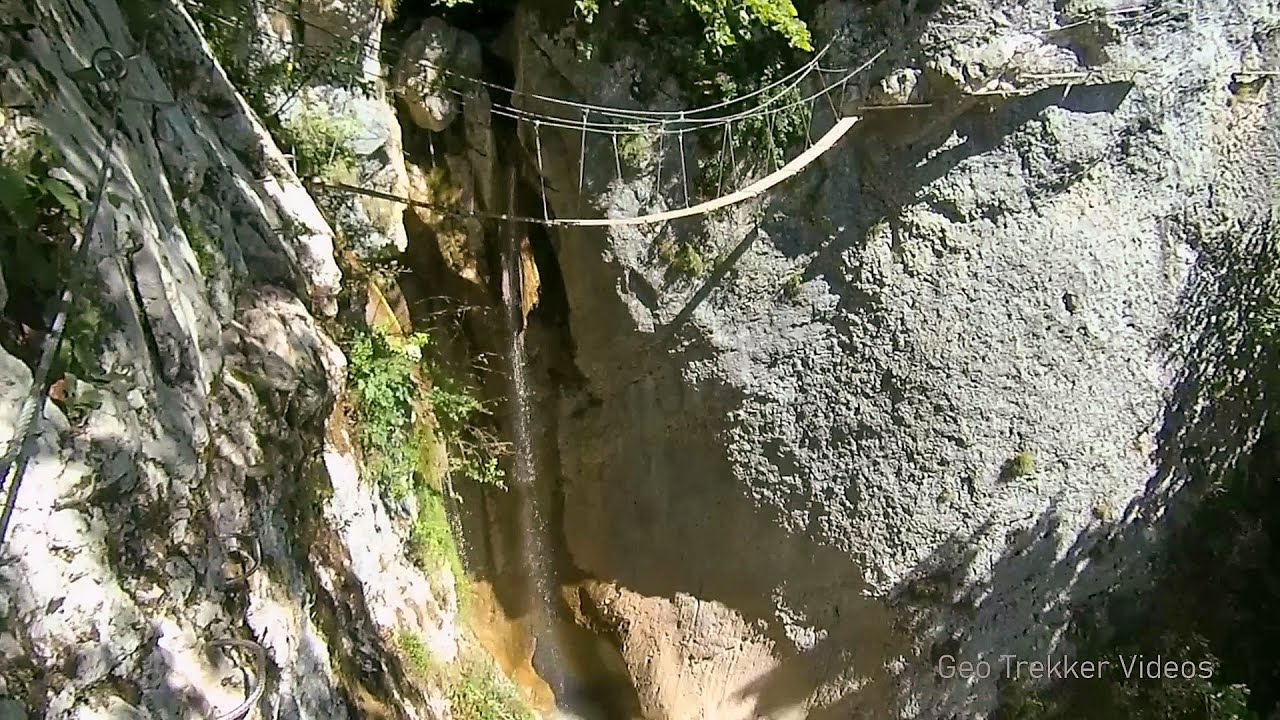
L'Escale á Peille iron path - Maritime Alps, France - video


One of the challenging via ferratas in the Maritime Alps is the l'Escale a Peille. One of its elements is a steel cobweb, where you can feel like you're hanging in the air. Read more
Music: Polychromatic Journey by MMFFF, Attribution 4.0 International (CC BY 4.0) license. Filmed with SJCAM SJ5000 Plus. Copyright © 2015 - 2025 Geo Trekker Videos.
Already published 8983 photos and 179 videos. Please register for full and ad-free access.
Photos of nearby places

Venice - Italy (60 photos) 430.45 km away
Venice (Venezia) is a city located in northeastern Italy, it is the capital of the region of Veneto. It is known for its unique setup of being built on a lagoon, on a group of islands separated by canals and connected by bridges.

Rome - Italy (24 photos) 466.01 km away
Rome is the capital city of Italy. With a history spanning over 2,800 years, it is one of the oldest continuously occupied cities in the world.

Boka Waterfall - Slovenia (11 photos) 553.12 km away
Boka (Slap Boka) is a waterfall in western Slovenia, near the Soca River. It has two stages, with the first being 106 m high and 18 m wide, and the second being 33 m high.

Kanin cableway and ski resort - Shooting window, Monte Forato, Bovec, Sella Nevea (48 photos) 554.49 km away
The Kanin Mountains are located in the Western Julian Alps, on the border of Slovenia and Italy. The highest peak in this range, known as (High) Kanin or Monte Canin Alto, in Slovenian and Italian respectively, reaches a height of 2,587 m above sea level.

Napoleon Bridge - Kobarid, Slovenia (22 photos) 556.51 km away
The Napoleon bridge (Napoleonov most) is located near Kobarid, on the banks of the Soca (Isonzo) river. The bridge has existed since ancient times, and has undergone multiple demolitions and reconstructions.

Slap Kozjak waterfall - Slovenia (24 photos) 557.43 km away
Slap Kozjak waterfall, perhaps the most beautiful waterfall in Slovenia, is situated near Kobarid. Located within the Kozjak stream gorge, and overlooking the stunning emerald green Soca River, this magnificent waterfall cascades 15 meters high, and is enclosed within a mesmerizing stone chamber.

Skocjan Caves - Slovenia (22 photos) 559.67 km away
The Skocjan Caves (Skocjanske jame) are a system of underground caves located in the Karst region of Slovenia. These caves are famous for their breathtaking natural beauty, and extensive underground river system.

Slap Savica waterfall - Slovenia (12 photos) 573.17 km away
Slap Savica, found in the northwestern part of Slovenia, is a magnificent, 78 m high waterfall. It derives its water from a karst spring called Savica located just above the falls.
[ Top ↑ ]
Videos of nearby places
Grande Fistoire iron path - Le Caire, Alpes-de-Haute-Provence 124.12 km away
Because I lost the footage I made the first time (don't buy SD cards from Alibaba!), at the end of June I visited this great and exciting via ferrata again.
The Gorge of the Méouge - Ribiers, Upper Alps 139.19 km away
Following today's climb, I experienced the soothing pleasure of immersing myself in the turquoise waters of the Méouge creek, in the pond beneath a waterfall. If you find yourself in Sisteron or Grenoble, do not miss the opportunity to explore the magnificent Méouge valley near Ribiers.
The Devil's Iron Path - Aussois, Savoy, Rhône Alps 165.15 km away
The Devil's Iron Path (Via ferrata du Diable) is a multi-part via ferrata, located above a spectacular waterfall (Cascade du Nant), in a gorge, below the Victor-Emmanuel fort. For me, this climbing route presented the greatest challenge so far (2015).
Rocher de l'envers iron path - Saint Vincent de Mercuze, Isére, Rhône Alps 210.28 km away
The Rocher de l'envers via ferrata is located in a beautiful environment, above Saint-Vincent-de-Mercuze, in France. Several beautiful and large waterfalls, as well as several small cascades, make it attractive.
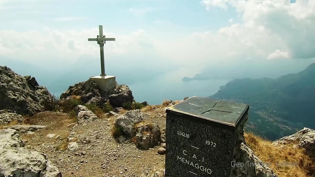
Via Ferrata Centenario C.A.O - Monte Grona, Prealpi Lombarde, Lombardia 288.62 km away
In the magnificent rocky world of Monte Grona, the Centenario via ferrata leads upwards, which I had the opportunity to climb accompanied by lizards. Although it was cloudy and gloomy, I had a great view of Lake Lugano and Lake Como along the way.
Other places
Grande Fistoire iron path Le Caire, Alpes-de-Haute-Provence 124.12 km away
Because I lost the footage I made the first time (don't buy SD cards from Alibaba!), at the end of June I visited this great and exciting via ferrata again.
Because I lost the footage I made the first time (don't buy SD cards from Alibaba!), at the end of June I visited this great and exciting via ferrata again.
Mürren-Gimmelwald Klettersteig Switzerland 308.85 km away
The Mürren-Gimmelwald Klettersteig is a relatively new via ferrata route in Switzerland, located in the Lauterbrunnen Valley. It is moderately difficult, but incredibly scenic.
The Mürren-Gimmelwald Klettersteig is a relatively new via ferrata route in Switzerland, located in the Lauterbrunnen Valley. It is moderately difficult, but incredibly scenic.
Handeckfallbrücke, Gelmerbahn, Gelmersee Schweiz 320.73 km away
Although the path from the Gelmerbahn parking bypasses the Handeckfall waterfall, it is worth descending a few steps from the valley station of the funicular, to reach Handeckfallbrücke. A 70-meter long suspension bridge that hangs 70 meters above the gorge, offering a spectacular view of the waterfall.
Although the path from the Gelmerbahn parking bypasses the Handeckfall waterfall, it is worth descending a few steps from the valley station of the funicular, to reach Handeckfallbrücke. A 70-meter long suspension bridge that hangs 70 meters above the gorge, offering a spectacular view of the waterfall.
Rocher de l'envers iron path Saint Vincent de Mercuze, Isére, Rhône Alps 210.28 km away
The Rocher de l'envers via ferrata is located in a beautiful environment, above Saint-Vincent-de-Mercuze, in France. Several beautiful and large waterfalls, as well as several small cascades, make it attractive.
The Rocher de l'envers via ferrata is located in a beautiful environment, above Saint-Vincent-de-Mercuze, in France. Several beautiful and large waterfalls, as well as several small cascades, make it attractive.
The Devil's Iron Path Aussois, Savoy, Rhône Alps 165.15 km away
The Devil's Iron Path (Via ferrata du Diable) is a multi-part via ferrata, located above a spectacular waterfall (Cascade du Nant), in a gorge, below the Victor-Emmanuel fort. For me, this climbing route presented the greatest challenge so far (2015).
The Devil's Iron Path (Via ferrata du Diable) is a multi-part via ferrata, located above a spectacular waterfall (Cascade du Nant), in a gorge, below the Victor-Emmanuel fort. For me, this climbing route presented the greatest challenge so far (2015).
[ Top ↑ ]
[ Top ↑ ]
Copyright © 2003-2025 Trekkingklub and friends. Reproduction of any text, picture or video from this website, either in printed or electronic form, is prohibited without prior written permission.
The given distances are to be understood as straight line distances, and are approximate. Website made in Miercurea Ciuc  .
.