Via Ferrata Centenario C.A.O - Monte Grona, Prealpi Lombarde, Lombardia - video


In the magnificent rocky world of Monte Grona, the Centenario via ferrata leads upwards, which I had the opportunity to climb accompanied by lizards. Although it was cloudy and gloomy, I had a great view of Lake Lugano and Lake Como along the way. Especially the peninsula in the middle of Lake Como, where Bellagio is located, caught my attention. Read more
Filmed with SJCAM SJ5000 Plus. Copyright © 2015 - 2025 Geo Trekker Videos. Music: Sapphire Wind by Maxim Kornyshev.
Already published 8983 photos and 179 videos. Please register for full and ad-free access.
Photos of nearby places

Venice - Italy (60 photos) 252.43 km away
Venice (Venezia) is a city located in northeastern Italy, it is the capital of the region of Veneto. It is known for its unique setup of being built on a lagoon, on a group of islands separated by canals and connected by bridges.

Kanin cableway and ski resort - Shooting window, Monte Forato, Bovec, Sella Nevea (48 photos) 329.34 km away
The Kanin Mountains are located in the Western Julian Alps, on the border of Slovenia and Italy. The highest peak in this range, known as (High) Kanin or Monte Canin Alto, in Slovenian and Italian respectively, reaches a height of 2,587 m above sea level.

Boka Waterfall - Slovenia (11 photos) 329.94 km away
Boka (Slap Boka) is a waterfall in western Slovenia, near the Soca River. It has two stages, with the first being 106 m high and 18 m wide, and the second being 33 m high.

Napoleon Bridge - Kobarid, Slovenia (22 photos) 337.56 km away
The Napoleon bridge (Napoleonov most) is located near Kobarid, on the banks of the Soca (Isonzo) river. The bridge has existed since ancient times, and has undergone multiple demolitions and reconstructions.

Slap Kozjak waterfall - Slovenia (24 photos) 337.94 km away
Slap Kozjak waterfall, perhaps the most beautiful waterfall in Slovenia, is situated near Kobarid. Located within the Kozjak stream gorge, and overlooking the stunning emerald green Soca River, this magnificent waterfall cascades 15 meters high, and is enclosed within a mesmerizing stone chamber.

Slap Savica waterfall - Slovenia (12 photos) 353.91 km away
Slap Savica, found in the northwestern part of Slovenia, is a magnificent, 78 m high waterfall. It derives its water from a karst spring called Savica located just above the falls.

Vogel Ski Resort - Slovenia (33 photos) 357.17 km away
Vogel Ski Resort is situated in Slovenia, above Bohinj and adjacent to Lake Bohinj, on the outskirts of Triglav National Park. The resort derives its name from the nearby Mount Vogel, and was established in 1964.

Lake Bohinj - Upper Carniola, Slovenia (10 photos) 360.57 km away
Lake Bohinj, also known as Bohinjsko jezero in Slovene and Wocheiner See in German, is the biggest permanent lake in Slovenia, covering a vast area of 318 hectares. Situated in the Bohinj Valley of the Julian Alps, in the northwestern region of Upper Carniola (Gorenjska, Alta Carniola, Oberkrain), it forms a part of the Triglav National Park.
[ Top ↑ ]
Videos of nearby places
Rhein Gorge - Flims, Switzerland 83.91 km away
The Rhine River (in German, Rhein) originates in the Swiss canton of Graubünden at the Oberalppass and flows into the North Sea at Rotterdam in the Netherlands after traveling 1,324 km. The Rhine Gorge, also known as the Swiss Grand Canyon (in Romansh, Ruinaulta), winds for 14 km between 350 m high white walls.
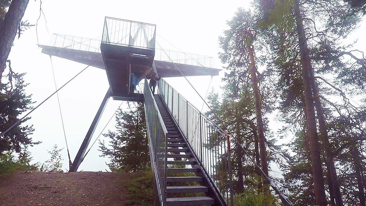
Handeckfallbrücke, Gelmerbahn, Gelmersee - Schweiz 91.87 km away
Although the path from the Gelmerbahn parking bypasses the Handeckfall waterfall, it is worth descending a few steps from the valley station of the funicular, to reach Handeckfallbrücke. A 70-meter long suspension bridge that hangs 70 meters above the gorge, offering a spectacular view of the waterfall.
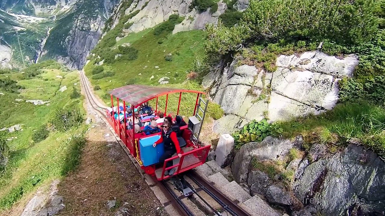
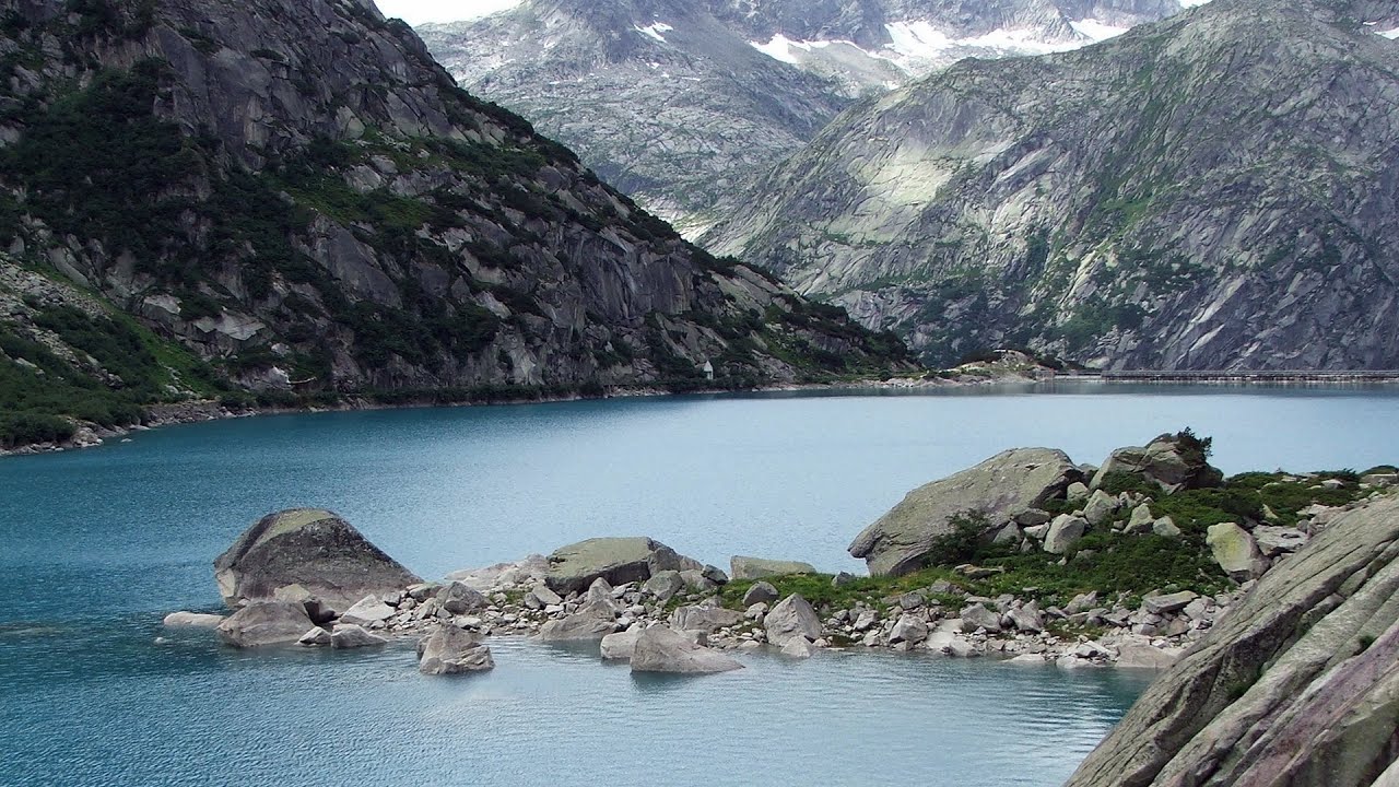
Gelmerbahn - Guttannen, Schweiz 92.56 km away
The Gelmerbahn in Switzerland is the steepest open funicular in Europe. It transports tourists from an altitude of 1412 meters to over 1860 meters above sea level, as well as to the Gelmer lake located at 1849 meters.
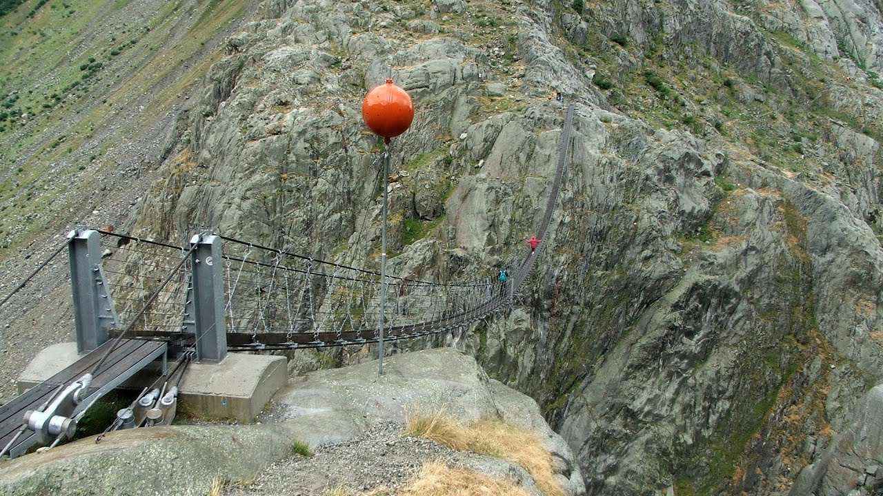
Trift valley, bridge, lake and glacier - Gadmen, Switzerland 96.11 km away
During the hike in Trift Valley, I experienced cloudy and gloomy weather with intermittent rain. Here is the 170 m long Trift Bridge, the longest pedestrian suspension bridge in the Swiss Alps, in a breathtaking environment, 100 meters above the Trift Glacier Lake.
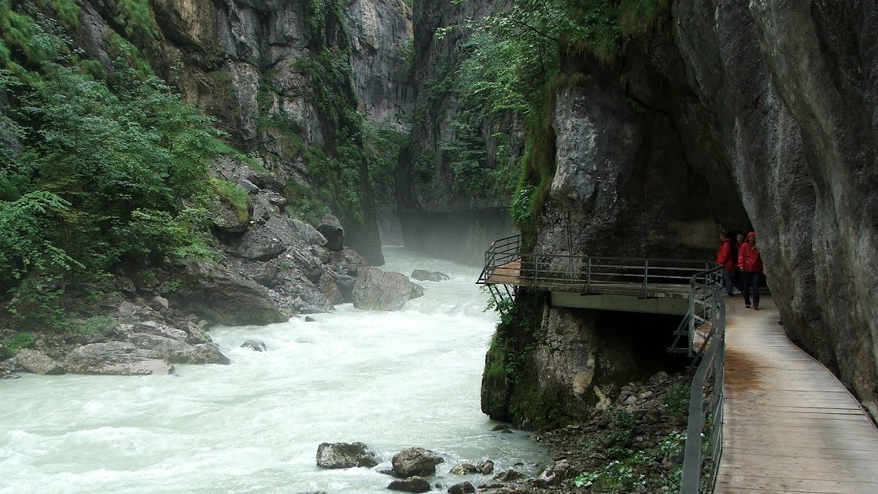
Aareschlucht - Meiringen-Innertkirchen, Switzerland 105.13 km away
The Aareschlucht is a 1400-meter long, 200-meter deep gorge of the Aare river, near Innertkirchen, Switzerland. It has two entrances, one from Meiringen in the west, and one from Innertkirchen in the east, which lead into the narrow, but stunning gorge.
Other places
Via ferrata Ernesto Che Guevara al Monte Casale, Monti del Garda, Trentino Alto Adige 133.65 km away
The Che Guevara via ferrata is the longest iron climbing route I have ever climbed. There is a 1400 m level difference from the starting point to the peak of Monte Casale.
The Che Guevara via ferrata is the longest iron climbing route I have ever climbed. There is a 1400 m level difference from the starting point to the peak of Monte Casale.
Via ferrata Rio Sallagoni Drena, Italia 133.42 km away
The surrounding iron climbing routes are located on rock walls exposed to a scorching sun. But the Rio Sallagoni via ferrata goes upwards in a pleasantly cool gorge, above the creek and waterfalls, and eventually reaches the Drena Castle.
The surrounding iron climbing routes are located on rock walls exposed to a scorching sun. But the Rio Sallagoni via ferrata goes upwards in a pleasantly cool gorge, above the creek and waterfalls, and eventually reaches the Drena Castle.
L'Escale á Peille iron path Maritime Alps, France 288.62 km away
One of the challenging via ferratas in the Maritime Alps is the l'Escale a Peille. One of its elements is a steel cobweb, where you can feel like you're hanging in the air.
One of the challenging via ferratas in the Maritime Alps is the l'Escale a Peille. One of its elements is a steel cobweb, where you can feel like you're hanging in the air.
The Devil's Iron Path Aussois, Savoy, Rhône Alps 214.25 km away
The Devil's Iron Path (Via ferrata du Diable) is a multi-part via ferrata, located above a spectacular waterfall (Cascade du Nant), in a gorge, below the Victor-Emmanuel fort. For me, this climbing route presented the greatest challenge so far (2015).
The Devil's Iron Path (Via ferrata du Diable) is a multi-part via ferrata, located above a spectacular waterfall (Cascade du Nant), in a gorge, below the Victor-Emmanuel fort. For me, this climbing route presented the greatest challenge so far (2015).
Aareschlucht Meiringen-Innertkirchen, Switzerland 105.13 km away
The Aareschlucht is a 1400-meter long, 200-meter deep gorge of the Aare river, near Innertkirchen, Switzerland. It has two entrances, one from Meiringen in the west, and one from Innertkirchen in the east, which lead into the narrow, but stunning gorge.
The Aareschlucht is a 1400-meter long, 200-meter deep gorge of the Aare river, near Innertkirchen, Switzerland. It has two entrances, one from Meiringen in the west, and one from Innertkirchen in the east, which lead into the narrow, but stunning gorge.
[ Top ↑ ]
[ Top ↑ ]
Copyright © 2003-2025 Trekkingklub and friends. Reproduction of any text, picture or video from this website, either in printed or electronic form, is prohibited without prior written permission.
The given distances are to be understood as straight line distances, and are approximate. Website made in Miercurea Ciuc  .
.