Vulva Cave (Peshtera Utroba) - photos


Page no. 1, photos: 1-10, 12 photos in total. >>>

Copyright © 2017 - 2025 Trekkingklub.com.
Already published 8983 photos and 179 videos. Please register for full and ad-free access.
Photos of nearby places


Canyon of Waterfalls eco-trail - Smolyan (8 photos) 52.83 km away
The Soskovcheto Reserve was established in 1968 and covers an area of 177 hectares. It is situated in the Perelishko-Prespanski region of the Rhodope Mountains.


Castle of Ravadinovo (In love with the wind) (79 photos) 214.06 km away
The Castle of Ravadinovo, situated near Sozopol in Bulgaria, is a enchanting structure that delights visitors with its fairytale-like appearance and distinctive charm. Also known as In Love with the Wind, this castle is the visionary project of architect Georgi Kostadinov Tumpalov, who dedicated himself to its design and construction from 1996 onward, transforming his dream into reality through perseverance and community support.

Drivers (Alepu) beach between Duni and Arkutino (6 photos) 216.32 km away
Drivers or Chauffeurs Beach, also known as Alepu Beach or Dunes, is one of the most renowned and scenic wild beaches along the South Black Sea coast. Located between Duni Resort to the north and Cape Humata to the south, the beach stretches nearly 3 kilometers in length and reaches a width of up to 70 meters.

Thracian Fortress Ranuli (Valchan's fortress) and the Lion's Head Rock (40 photos) 216.39 km away
On Copper Ridge (Meden Rid), overlooking the Ropotamo River, the Thracian miner tribe Skirmiani constructed a fortress. During the first and second millennia BC, they arranged large megalithic stones to build walls and structures.
[ Top ↑ ]
Videos of nearby places
Vulva cave - Rhodope Mountains 0 km away
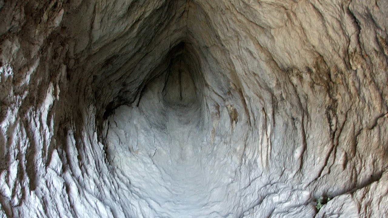
The Vulva Cave (Peshtera Utroba) is situated near the village of Nenkovo and the city of Kardzhali, in the Rhodope Mountains of Bulgaria. It derives its name from the shape of its entrance, which resembles a vulva.
The Stone Wedding - Zimzelen, Kardzhali 13.67 km away
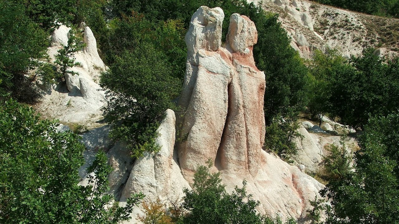
The Stone Wedding (Kamenna Svatba, Petrified Wedding, Kardzhali Pyramids) is located near the village of Zimzelen, close to the city of Kardzhali, in the eastern part of the Rhodope Mountains in Bulgaria. This spectacular natural formation was declared a natural monument in 1974.
Dyavolski Most (Devil's Bridge) - Ardino 14.54 km away
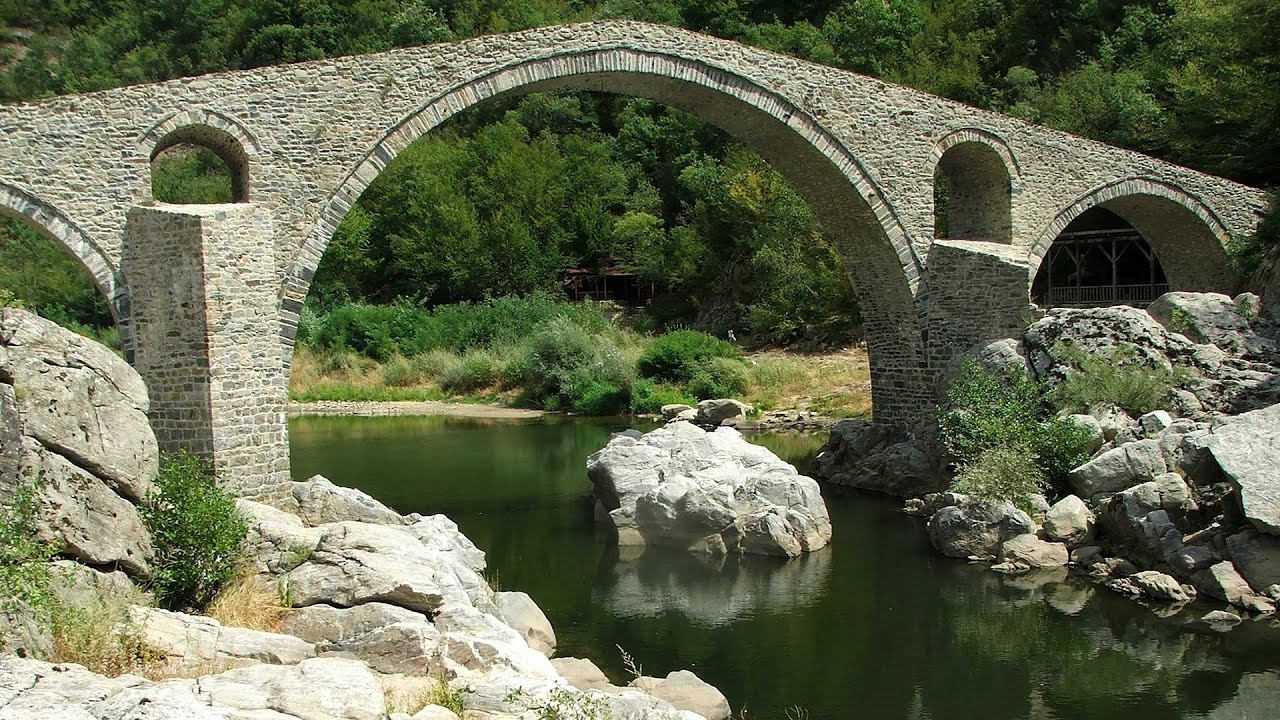
The Devil's Bridge (Dyavolski Most, in Turkish Sheytan Kyupriya) is located in the gorge of the Arda River, just north of the town of Ardino in Bulgaria. It was constructed in the early 16th century, between 1515 and 1518, by an architect named Dimitar, on the remains of an earlier Roman bridge.
Kamenni Gabi (Stone Mushrooms) - Beli Plast 17.74 km away
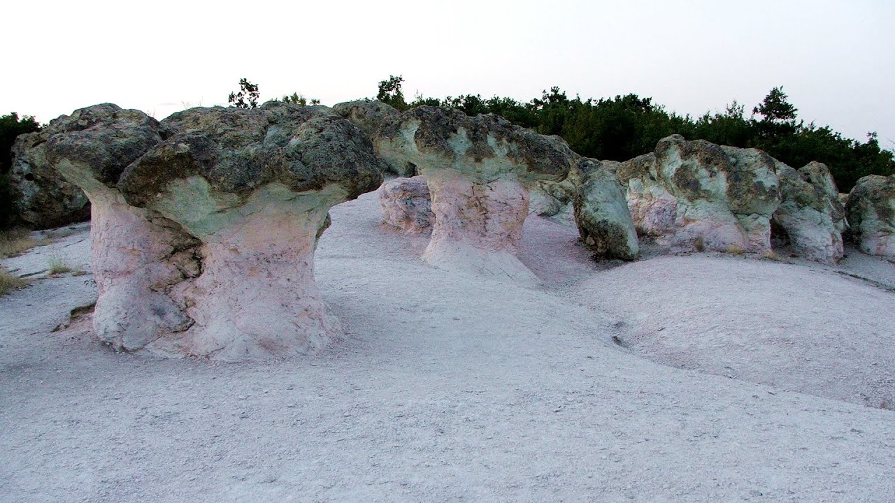
The Stone Mushrooms (Kamenni Gabi) nature reserve in Bulgaria is situated east of the village of Beli Plast, along the road that connects Kardzhali to Haskovo. Spanning an area of 3 hectares, the reserve is home to several mushroom-shaped rock formations.
Neviastata ecopath and iron path - Smolyan 47.88 km away
The Neviastata eco-trail is located in Bulgaria, nestled in the heart of the Rhodope Mountains, between Smolyan and Pamporovo. Here, you will find a small, paid adventure park.
Other places
Babsko Praskalo waterfall Tazha 112.32 km away
In the Central Balkans National Park, there are many rivers that cascade down spectacular waterfalls, which the locals call praskalo. One of the smallest waterfalls in the area is Babsko Praskalo, which stands at only 54 meters high.
In the Central Balkans National Park, there are many rivers that cascade down spectacular waterfalls, which the locals call praskalo. One of the smallest waterfalls in the area is Babsko Praskalo, which stands at only 54 meters high.
Pobiti Kamani (Stone Forest) Slanchevo 263.3 km away
The Stone Forest of Bulgaria is located 18 km west of Varna, at the foothills of the Eastern Balkan Mountains. Its Bulgarian name, Pobiti Kamani, translates to planted stones, and it is referred to in English as the Stone Desert or Stone Forest.
The Stone Forest of Bulgaria is located 18 km west of Varna, at the foothills of the Eastern Balkan Mountains. Its Bulgarian name, Pobiti Kamani, translates to planted stones, and it is referred to in English as the Stone Desert or Stone Forest.
Borov Kamak waterfall Zgorigrad, Vratsa 215.3 km away
The Vratsa eco-trail starts from the village of Zgorigrad, located 6 km from the city of Vratsa in Bulgaria, and ends at the Parshevitza hut. It is also known as the Zgorigradska or Borov Kamak eco-trail.
The Vratsa eco-trail starts from the village of Zgorigrad, located 6 km from the city of Vratsa in Bulgaria, and ends at the Parshevitza hut. It is also known as the Zgorigradska or Borov Kamak eco-trail.
Iskar gorge (Lyutibrod) Temnata dupka cave (Lakatnik) 217.01 km away
The Iskar is the longest purely Bulgarian river, the oldest river in the Balkans, and a right tributary of the Danube. The river is 368 km long, with approximately 150 km consisting of a gorge.
The Iskar is the longest purely Bulgarian river, the oldest river in the Balkans, and a right tributary of the Danube. The river is 368 km long, with approximately 150 km consisting of a gorge.
Canyon of Waterfalls Smolyan 52.83 km away
The eco-trail known as the Canyon of Waterfalls is located in Bulgaria, within the Rhodope Mountains and the Soskovcheto Nature Reserve. It begins at the edge of the Sredoka suburb of the city of Smolyan.
The eco-trail known as the Canyon of Waterfalls is located in Bulgaria, within the Rhodope Mountains and the Soskovcheto Nature Reserve. It begins at the edge of the Sredoka suburb of the city of Smolyan.
Planned destinations
Roman bridge Nenkovo 3.95 km away
Along the Borovitsa River, near the village of Nenkovo, there is a Roman Bridge. It connects the two banks of the Borovitsa River.
Along the Borovitsa River, near the village of Nenkovo, there is a Roman Bridge. It connects the two banks of the Borovitsa River.
Parmak Kaya (Finger Rock) Nochevo, Panichkovo 19.19 km away
Between the villages of Nochevo and Panichkovo in Chernoochene Municipality, Kardzhali Province, lies Parmak Kaya. The site features ancient carvings and rock formations within an old pine forest.
Between the villages of Nochevo and Panichkovo in Chernoochene Municipality, Kardzhali Province, lies Parmak Kaya. The site features ancient carvings and rock formations within an old pine forest.
Thracian stone sharapani (Grape processing containers) Nochevo 19.53 km away
Sharapani is a traditional stone container used by ancient Thracians for processing grapes in wine production. Two well-preserved sharapani containers are located about 200 meters apart.
Sharapani is a traditional stone container used by ancient Thracians for processing grapes in wine production. Two well-preserved sharapani containers are located about 200 meters apart.
Kamennata pateka (The Stone Path) Nochevo 19.66 km away
[ Top ↑ ]
[ Top ↑ ]
Copyright © 2003-2025 Trekkingklub and friends. Reproduction of any text, picture or video from this website, either in printed or electronic form, is prohibited without prior written permission.
The given distances are to be understood as straight line distances, and are approximate. Website made in Miercurea Ciuc  .
.