Stone Forest (Stones stuck in the ground, Pobiti Kamani) - Slanchevo | Video

The Stone Forest of Bulgaria is located 18 km west of Varna, at the foothills of the Eastern Balkan Mountains. Its Bulgarian name, Pobiti Kamani, translates to planted stones, and it is referred to in English as the Stone Desert or Stone Forest. This nature reserve is the only desert in Bulgaria and Eastern Europe, featuring sand dunes and stone columns.
Read more
Filmed with GoPro HERO5 Black. Music: Tumult by Kai Engel. Copyright © 2017 - 2025 Geo Trekker Videos.
Already published 8983 photos and 180 videos. Please register for full and ad-free access.
Photos of nearby places


Wonderful Rocks (Chudnite skali) - Asparuhovo (24 photos) 44.37 km away
The Wonderful Rocks, a very beautiful and impressive rock formation, are located on the right bank of the Luda Kamchiya River, on the shores of the Tsonevo Reservoir and near the village of Asparuhovo. They have the shapes of pointed, tall cones and pyramids.

Replica of the Eiffel Tower and Arc de Triomphe - Sveti Vlas (5 photos) 57.62 km away
Small-sized replica of the Eiffel Tower and Arc de Triomphe, in front of the decorative pool at the Romance Paris luxury hotel complex, in Sveti Vlas (Saint Blaise) resort.


The Gate of the 40 Virgins (12 photos) 63.32 km away
The Gate of the 40 Virgins, The monument to Admiral Ushakov on Cape Kaliakra.


UNESCO World Heritage Site: Nesebar, the pearl of the Black Sea (20 photos) 63.37 km away
Nesebar is an ancient Bulgarian city on the Black Sea Coast, today a UNESCO World Heritage Site. It is renowned for its over three thousand years of history, diverse cultural heritage, and well-preserved medieval monuments.

[ Top ↑ ]
Videos of nearby places
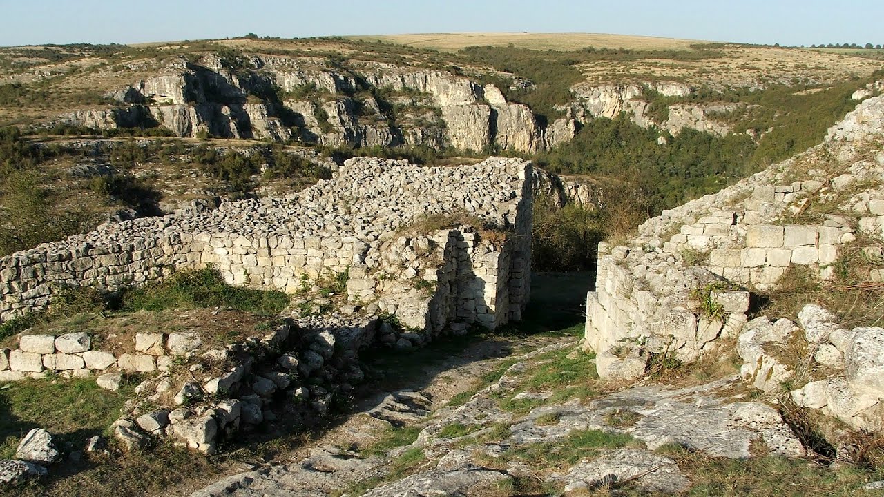
Cherven, a medieval fortified town - Bulgaria 142.84 km away
Located about 30 km south of the city of Ruse in Bulgaria, the Cherven medieval fortress can be found in the Rusenski Lom Nature Park. Originally a Byzantine fortification from the 6th century, it reached the height of its development in the 14th century.
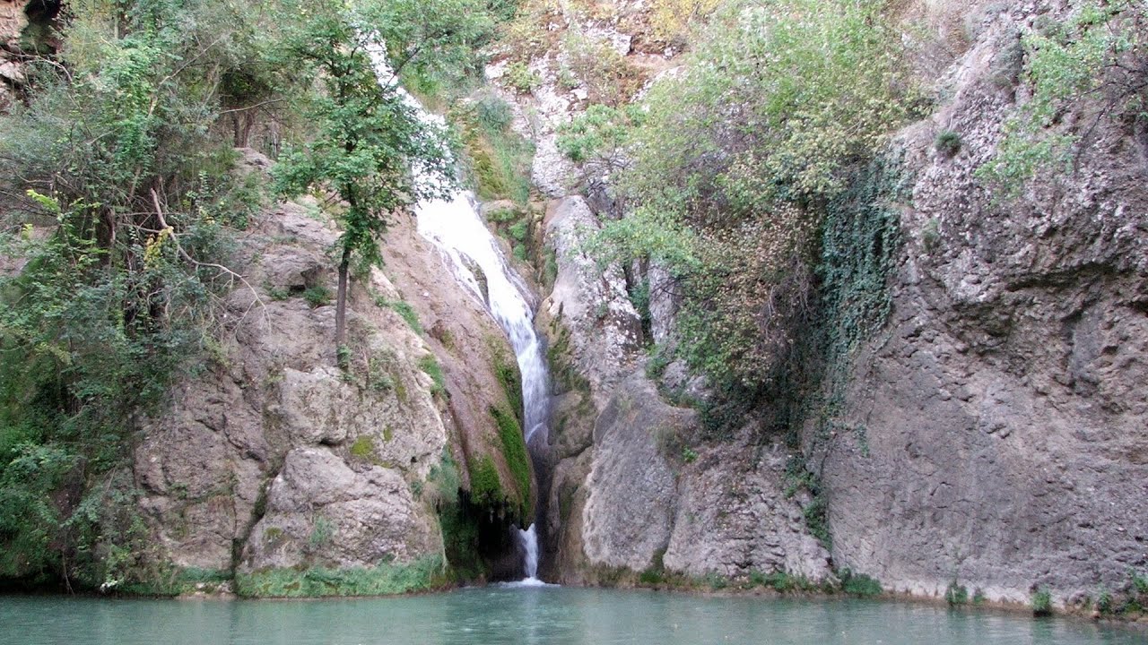
Kaya Bunar (Hotnishki Vodopadi, Hotnitsa Waterfall) - Hotnitsa 177.89 km away
The Kaya Bunar Waterfall (Hotnishki Vodopadi) is located 20 km from the city of Veliko Tarnovo in Bulgaria. The waterfall is 30 meters high, and there are several smaller cascades above it.

Buzludzha monument - Kazanluk 195.85 km away
Buzludzha is a historically significant mountain located in the Central Balkan Mountains of Bulgaria. At its summit, at an altitude of 1432 meters above sea level, there is an abandoned monument.
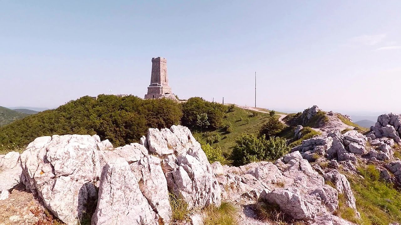
Shipka pass - Shipka 201.14 km away
The Shipka Pass is one of the most spectacular crossings of the Balkan Mountains, and is part of the Bulgarka Nature Park. It separates the provinces of Gabrovo and Stara Zagora, and provides a connection between the cities of Gabrovo and Kazanlak.
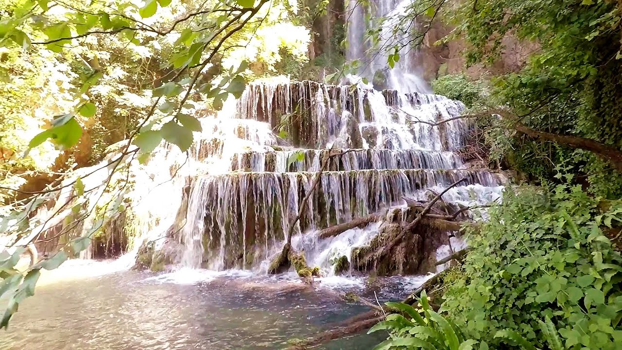
Krushuna waterfalls - Krushuna 216.45 km away
The Krushuna Waterfalls are a series of karst cascades formed in travertine. They are located near the village of Krushuna, not far from the town of Lovech, and are Bulgaria's largest waterfall of this type.
Other places
Byala Reka eco-trail Kalofer 232.17 km away
The Byala Reka eco-trail is situated at the foot of the Stara Planina mountain range, 8 km from the town of Kalofer. A 1,830-meter-long hiking trail has been established along the White Creek within the Central Balkan National Park.
The Byala Reka eco-trail is situated at the foot of the Stara Planina mountain range, 8 km from the town of Kalofer. A 1,830-meter-long hiking trail has been established along the White Creek within the Central Balkan National Park.
Canyon of Waterfalls Smolyan 311.5 km away
The eco-trail known as the Canyon of Waterfalls is located in Bulgaria, within the Rhodope Mountains and the Soskovcheto Nature Reserve. It begins at the edge of the Sredoka suburb of the city of Smolyan.
The eco-trail known as the Canyon of Waterfalls is located in Bulgaria, within the Rhodope Mountains and the Soskovcheto Nature Reserve. It begins at the edge of the Sredoka suburb of the city of Smolyan.
Dyavolski Most (Devil's Bridge) Ardino 277.84 km away
The Devil's Bridge (Dyavolski Most, in Turkish Sheytan Kyupriya) is located in the gorge of the Arda River, just north of the town of Ardino in Bulgaria. It was constructed in the early 16th century, between 1515 and 1518, by an architect named Dimitar, on the remains of an earlier Roman bridge.
The Devil's Bridge (Dyavolski Most, in Turkish Sheytan Kyupriya) is located in the gorge of the Arda River, just north of the town of Ardino in Bulgaria. It was constructed in the early 16th century, between 1515 and 1518, by an architect named Dimitar, on the remains of an earlier Roman bridge.
Stan Valley Canyon in winter 342.64 km away
The Stan Valley is a picturesque canyon, even in winter. In fact, when the stream is frozen and covered with a layer of snow, exploring the canyon becomes much quicker and easier.
The Stan Valley is a picturesque canyon, even in winter. In fact, when the stream is frozen and covered with a layer of snow, exploring the canyon becomes much quicker and easier.
Waterfalls of Velnita stone-quarry Targu Ocna 347.22 km away
Starting from the Velnita quarry, an adventurous nature enthusiast, accustomed to wild and rugged terrains, will discover a true waterfall paradise. At the upper part of the quarry, two streams converge.
Starting from the Velnita quarry, an adventurous nature enthusiast, accustomed to wild and rugged terrains, will discover a true waterfall paradise. At the upper part of the quarry, two streams converge.
Planned destinations
Abandoned Sports Hall Varna 20.58 km away
An abandoned sports hall in Varna, with an unfinished dormitory and tennis courts across three levels.
An abandoned sports hall in Varna, with an unfinished dormitory and tennis courts across three levels.
[ Top ↑ ]
[ Top ↑ ]
Select language: - Magyar - Romana - Deutsch - Français - Italiano - Español - Български - 中文 - Copyright © 2003-2025 Trekkingklub and friends. Reproduction of any text, picture or video from this website, either in printed or electronic form, is prohibited without prior written permission. The given distances are to be understood as straight line distances, and are approximate. Website made in Miercurea Ciuc