Stone Ships (Kamennite korabi) - Sinemorets - photos


Page no. 1, photos: 1-10, 14 photos in total. >>>

Copyright © 2025 Trekkingklub.com.
Already published 8971 photos and 179 videos. Please register for full and ad-free access.
Photos of nearby places

Rock formation The Pharaoh (Sfinx) - Veleka Beach, Sinemorets (12 photos) 1.01 km away
The Veleka beach is located northwest of the village of Sinemorets, at the mouth of the Veleka River, which it bypasses from the west. At the southeastern end of the seaside beach, there is a cliff, which, when viewed from the west, resembles a human head profile, and from the east, resembles a pharaoh's mummy.


Where the sea meets the rocks - Sinemorets (10 photos) 2.27 km away
Just about 300 meters away from the southern end of the Lipite beach, the sea meets the rock in a strange way. The roles are reversed, above the relatively calm water the cliff curves out in the form of fossilized waves.

Split Cliff (Razdelenata kanara) - Sinemorets (10 photos) 2.79 km away
The Split Cliff, also known as Divided Rock, is an interesting rock formation located south of Sinemorets and north of Listi Beach. There is a trail along the plateau, starting from either Listi or Lipite Beach.

Silistar Beach - Rezovo (4 photos) 5.05 km away
Located 5 km south of Sinemorets, on the way to Rezovo, you'll find the turn-off to the last beach before the Turkey border. After approximately 1 km of dirt road winding through a forest, you'll arrive at a parking area.

The Rock Gate (Skalnata porta) and the Red Bay (Cherveniat zaliv) - Rezovo (8 photos) 5.25 km away
The Rock Gate (Skalnata porta) and the Red Bay (Cherveniat zaliv) are located at the southeastern end of Silistar Beach. Here, two massive rock formations rise from the water, forming a gate.

[ Top ↑ ]
Videos of nearby places
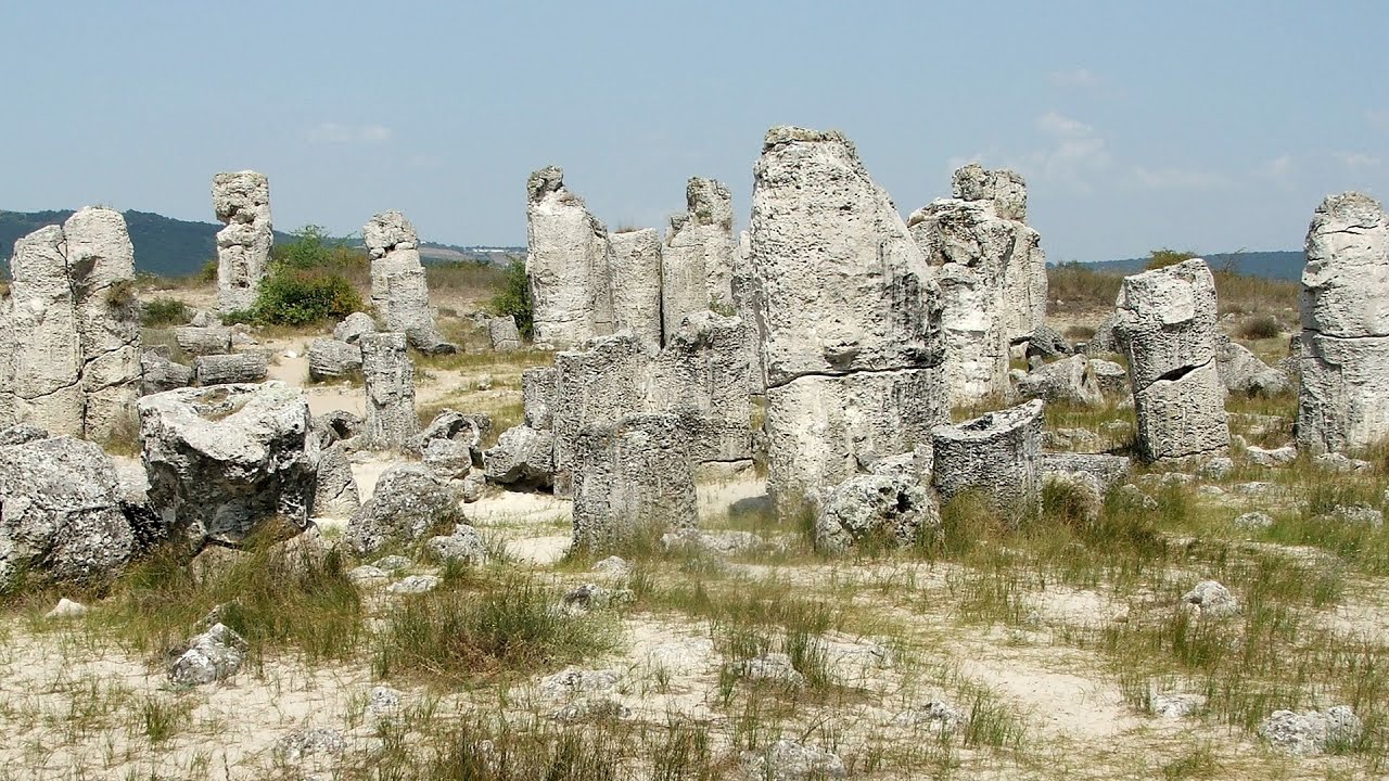
Pobiti Kamani (Stone Forest) - Slanchevo 131.47 km away
The Stone Forest of Bulgaria is located 18 km west of Varna, at the foothills of the Eastern Balkan Mountains. Its Bulgarian name, Pobiti Kamani, translates to planted stones, and it is referred to in English as the Stone Desert or Stone Forest.
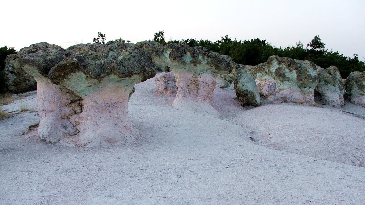
Kamenni Gabi (Stone Mushrooms) - Beli Plast 213.55 km away
The Stone Mushrooms (Kamenni Gabi) nature reserve in Bulgaria is situated east of the village of Beli Plast, along the road that connects Kardzhali to Haskovo. Spanning an area of 3 hectares, the reserve is home to several mushroom-shaped rock formations.
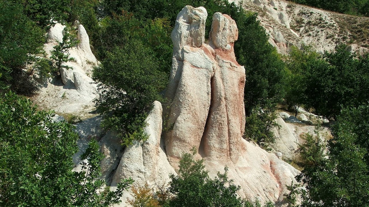
The Stone Wedding - Zimzelen, Kardzhali 218.99 km away
The Stone Wedding (Kamenna Svatba, Petrified Wedding, Kardzhali Pyramids) is located near the village of Zimzelen, close to the city of Kardzhali, in the eastern part of the Rhodope Mountains in Bulgaria. This spectacular natural formation was declared a natural monument in 1974.

Buzludzha monument - Kazanluk 225.56 km away
Buzludzha is a historically significant mountain located in the Central Balkan Mountains of Bulgaria. At its summit, at an altitude of 1432 meters above sea level, there is an abandoned monument.
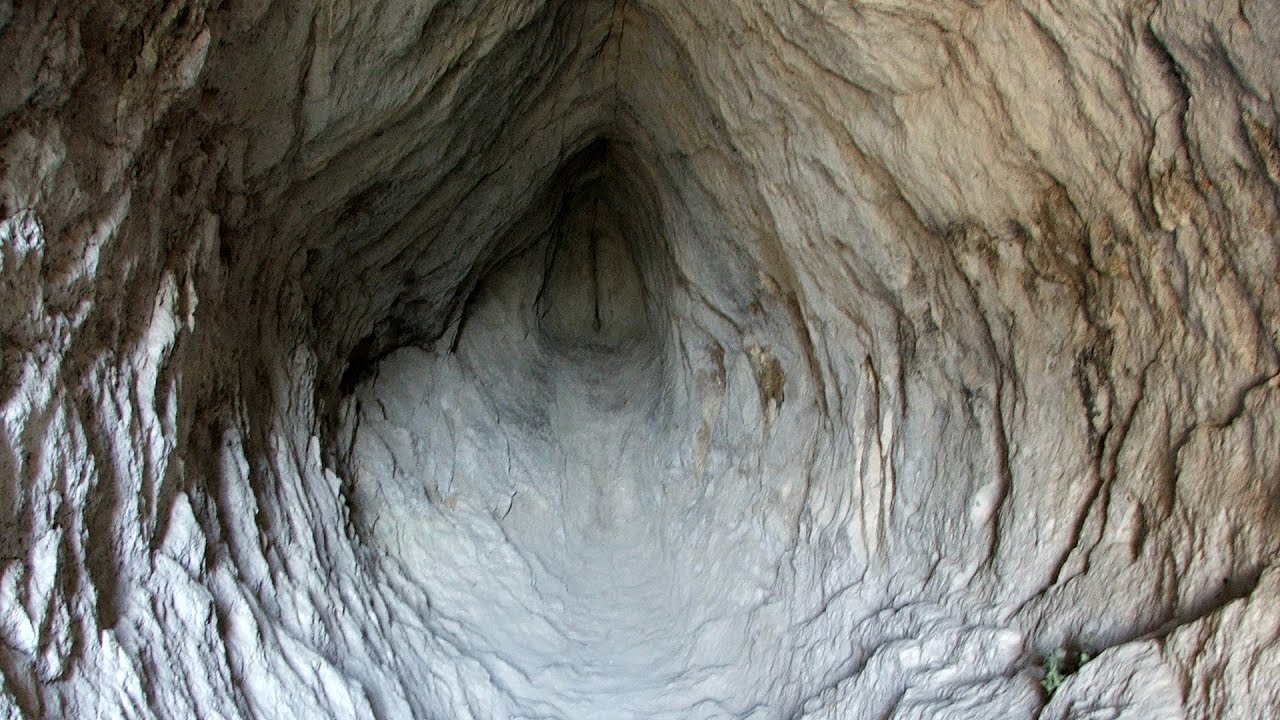
Vulva cave - Rhodope Mountains 230.17 km away
The Vulva Cave (Peshtera Utroba) is situated near the village of Nenkovo and the city of Kardzhali, in the Rhodope Mountains of Bulgaria. It derives its name from the shape of its entrance, which resembles a vulva.
Other places
Canyon of Waterfalls Smolyan 282.92 km away
The eco-trail known as the Canyon of Waterfalls is located in Bulgaria, within the Rhodope Mountains and the Soskovcheto Nature Reserve. It begins at the edge of the Sredoka suburb of the city of Smolyan.
The eco-trail known as the Canyon of Waterfalls is located in Bulgaria, within the Rhodope Mountains and the Soskovcheto Nature Reserve. It begins at the edge of the Sredoka suburb of the city of Smolyan.
Krushuna waterfalls Krushuna 274.77 km away
The Krushuna Waterfalls are a series of karst cascades formed in travertine. They are located near the village of Krushuna, not far from the town of Lovech, and are Bulgaria's largest waterfall of this type.
The Krushuna Waterfalls are a series of karst cascades formed in travertine. They are located near the village of Krushuna, not far from the town of Lovech, and are Bulgaria's largest waterfall of this type.
Cherven, a medieval fortified town Bulgaria 235.98 km away
Located about 30 km south of the city of Ruse in Bulgaria, the Cherven medieval fortress can be found in the Rusenski Lom Nature Park. Originally a Byzantine fortification from the 6th century, it reached the height of its development in the 14th century.
Located about 30 km south of the city of Ruse in Bulgaria, the Cherven medieval fortress can be found in the Rusenski Lom Nature Park. Originally a Byzantine fortification from the 6th century, it reached the height of its development in the 14th century.
Prohodna cave (The Eyes of God) Karlukovo 343.07 km away
The cave nicknamed The Eyes of God is located in Bulgaria, in the Iskar Gorge, on one of the largest karst areas in Bulgaria, 2 km from the town of Karlukovo. It is essentially a 262-meter-long natural stone bridge, with a large (45 m high) and a small (35 m high) entrance.
The cave nicknamed The Eyes of God is located in Bulgaria, in the Iskar Gorge, on one of the largest karst areas in Bulgaria, 2 km from the town of Karlukovo. It is essentially a 262-meter-long natural stone bridge, with a large (45 m high) and a small (35 m high) entrance.
Vulva cave Rhodope Mountains 230.17 km away
The Vulva Cave (Peshtera Utroba) is situated near the village of Nenkovo and the city of Kardzhali, in the Rhodope Mountains of Bulgaria. It derives its name from the shape of its entrance, which resembles a vulva.
The Vulva Cave (Peshtera Utroba) is situated near the village of Nenkovo and the city of Kardzhali, in the Rhodope Mountains of Bulgaria. It derives its name from the shape of its entrance, which resembles a vulva.
Planned destinations
Listi bay and wild beach Sinemorets 3.3 km away
The Listi Beach is located between Lipite Beach and Silistar Beach. Historically, pirates had their hideouts along these shores.
The Listi Beach is located between Lipite Beach and Silistar Beach. Historically, pirates had their hideouts along these shores.
Fox Ears Beach (Plazh Lisichi ushi) Sinemorets 3.84 km away
Stone Beach (Kamenniat plazh) Sinemorets 4.82 km away
[ Top ↑ ]
[ Top ↑ ]
Copyright © 2003-2025 Trekkingklub and friends. Reproduction of any text, picture or video from this website, either in printed or electronic form, is prohibited without prior written permission.
The given distances are to be understood as straight line distances, and are approximate. Website made in Miercurea Ciuc  .
.