Tourist attractions near Ohaba-Forgaci (Boldur, Timis county, Romania)
Photos of nearby places

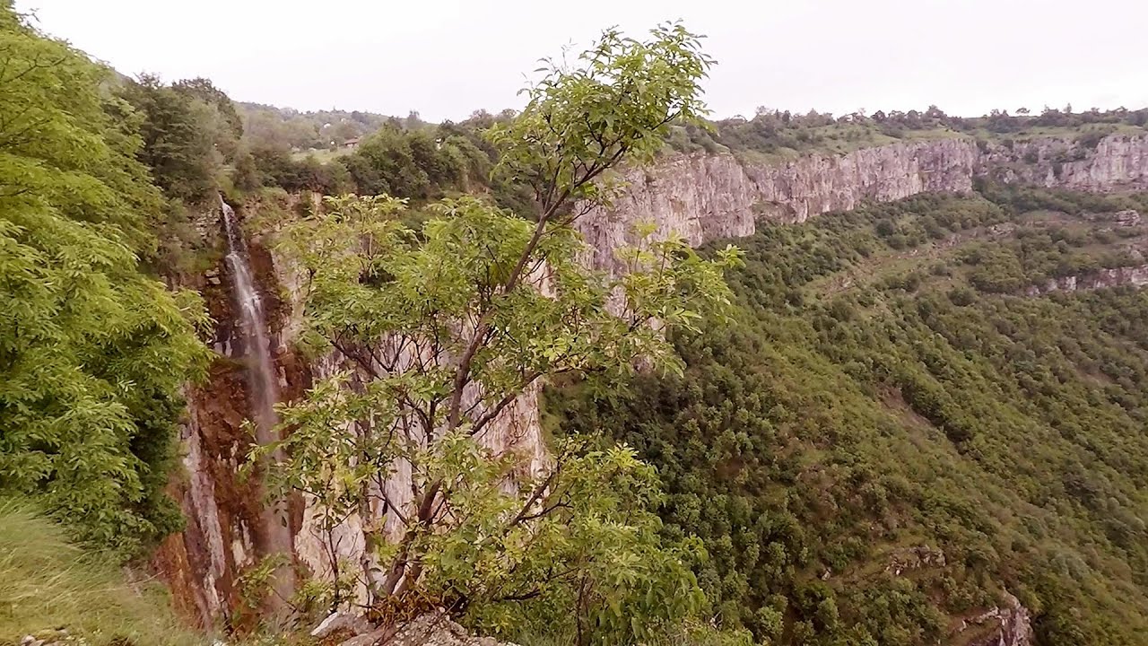
Beusnita waterfall (8 photos) 87.3 km away. Cascada Beusnita, located in the Caras-Severin county, is one of the most impressive waterfalls in the Anina Mountains. The water falling from a height of approximately 15 m, into a clearing in the middle of the forest, creates a uniquely picturesque landscape.


Natural bridge next to the Banita Stone Quarry (12 photos) 122.2 km away. Although the Banita Stone Bridge is not far from the road that passes through the village, it is located beyond the railway line, so its approach is a bit cumbersome. We can go around the railway line on Carierei Street, and then we have to walk a few meters from the stone quarry.


Banita Gorge - Banita (16 photos) 125.8 km away. The approximately 250 m long gorge, similar to the Corcoaia Gorge, is truly spectacular. According to assumptions, it was formed by the collapse of a cave passage ceiling, and then the erosion formed spectacular karst formations in the limestone.

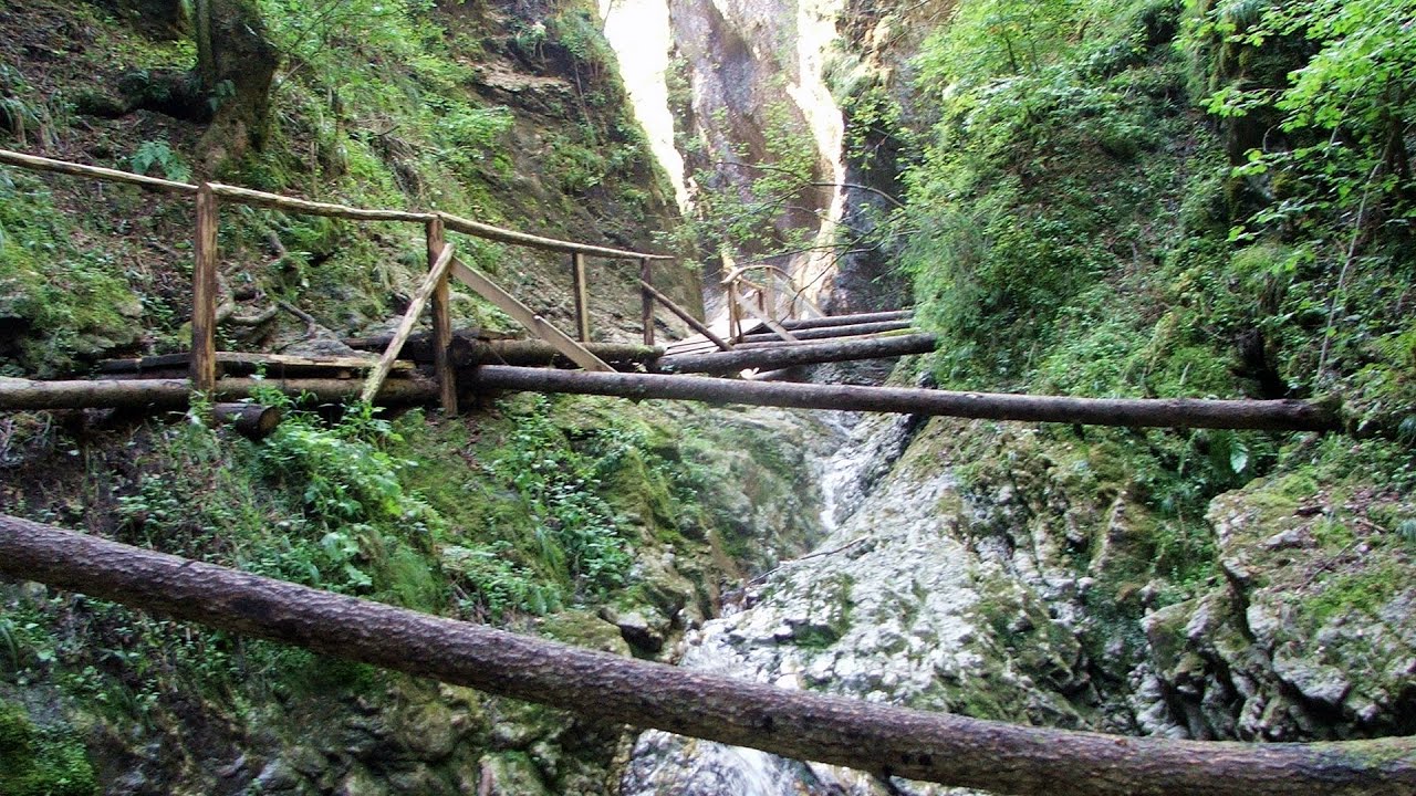
Boli Cave - Banita (20 photos) 126.2 km away. The main cave passage is approximately 460 m long, with an entrance portal that is 10 m high and 20 m wide at its base. In the 1960s, bridges were built over the underground stream flowing through the cave.


Kings Cave - Padurea Craiului Mountains (48 photos) 135.6 km away. Craiului (Kings) Cave - Padurea Craiului Mountains.

Fern Cave - Padurea Craiului Mountains (9 photos) 138 km away. Ferigi (Fern) Cave - Padurea Craiului Mountains.

Valley of Hell - Padurea Craiului Mountains (23 photos) 138.2 km away. Valley of Hell (Valea Iadului) - Padurea Craiului Mountains.

Sohodol pit cave - Padurea Craiului Mountains (10 photos) 139 km away. Sohodol pit cave (Avenul Sohodol) - Padurea Craiului Mountains.


Moanei Cave - Padurea Craiului Mountains (58 photos) 144.5 km away. The Moanei Cave (Pestera Moanei) is located on the upper course of the Misid River, on the right side of the Misid Gorge (Cheilor Misidului). The cave has two entrances, one fossil and sloped, while a subterranean stream flows through the active gallery.

Goat Stone - Craiva, Trascau Mountains (18 photos) 145.4 km away. Goat Stone (Piatra Craivii, Piatra Craivei, Apulon) - Craiva, Trascau Mountains.

Parangul Mare peak (16 photos) 146.2 km away. Chamois saddle (Saua Caprelor), Carja mountain shelter (Refugiul Carja) - Carja peak (Varful Carja) - Stoienita peak (Varful Stoienita) - Gemanarea - Parangul Mare peak.

Goats Ledge - Trascau Mountains (10 photos) 147.5 km away. Goats Ledge (Brana Caprei, Kecskék párkánya) - Trascau Mountains .

Stone of Cetea, Horse Pit - Trascau (16 photos) 147.9 km away. Stone of Cetea, Horse Pit (The pit cave from the Stone of Cetea) - Trascau Mountains.

Oxen Waterfall - Padurea Craiului Mountains (12 photos) 148.1 km away. Oxen Waterfall (Cascada Boilor) - Padurea Craiului Mountains.

The cave from the spring - Padurea Craiului Mountains (8 photos) 148.5 km away. Pestera de la Izvor (The cave from the spring) - Padurea Craiului Mountains.
[ Top ↑ ]
Videos of nearby places

Rudariei watermills - Eftimie Murgu 98.7 km away. I have visited the twenty-two wooden water mills with horizontal wheels, located in the valley of the Rudaria stream, mostly in the rain and under an umbrella. Some of them are still in use today.

Corcoaia Gorge - Gorj county 98.8 km away. The Corcoaia Gorge is one of the most beautiful tourist attractions in the Cerna Valley. It can be reached by car, 43 km away from Baile Herculane, of which about 17 km is on a dusty gravel road.

Billy-goat lake, Closed Gates - Retezat Mountains 99.7 km away. The most unique ridge trail of the Retezat Mountains is the Closed Gates.Below, at an altitude of 2070 m above sea level, is the Billy-goat lake.

Blasted Rock hanging path - Cerna Valley 100.4 km away. The Blasted Rock (Piatra Puscata) hanging path is located on the geographical right bank of the Cerna River, near the confluence of the Iuta stream, approximately 20 km from Baile Herculane. In this area, the presence of limestone formations has caused the valley to become narrower.

The Wooden Ladders - The villages of Scarisoara and Inelet, Cerna valley 100.4 km away. Scarisoara and Inelet are small, isolated villages located in the mountainous region of Banat. They are situated on the right bank of the Cerna River, approximately 19 km away from the Baile Herculane resort.
Other places
Devils Mill Gorge Campulung Moldovenesc 354.3 km away. The Devil's Mill Gorge is relatively short, measuring only 60 to 70 meters in length. It was formed in yellowish-gray-white dolomite by the work of a stream that crosses the gorge, as a result of erosion and the dissolution characteristic of limestone.

Stone Forest Slanchevo The Stone Forest (Stones stuck in the ground, Pobiti Kamani) of Bulgaria is located 18 km west of Varna, at the foothills of the Eastern Balkan Mountains. Its Bulgarian name, Pobiti Kamani, translates to planted stones, and it is referred to in English as the Stone Desert or Stone Forest.
Bovska Skaklya waterfall Iskar gorge 324 km away. The Bovska Skaklya waterfall is located near the town of Svoge in Bulgaria. The waterfall formed on the Zaselska River has several reported heights online (120 m, 85 m).
White Drin waterfall 350.6 km away. Drini i Bardhe (White Drin) waterfall.
Suchurum waterfall Karlovo 419.5 km away. The 15-meter-high Suchurum Waterfall is located at the foot of the Stara Planina mountain range, 1 km north of the town of Karlovo in Bulgaria. It is situated below the Karlovo hydroelectric power plant, on the waters of the Stara Reka stream.
Oltet Gorge Capatana Mountains 168.9 km away. Oltet Gorge (Cheile Oltetului) - Capatana Mountains. That day, we had planned to ski at the Ranca resort, situated alongside the Transalpina high altitude mountain road in the Parang Mountains.
Belintash Ridge of Dobrostan, Rhodope Mountains Belintash is a mysterious monolithic complex located approximately 50 km from Plovdiv, passing through the scenic Rhodope Mountains. It is situated southeast of the village of Vrata and west of the village of Sini Vruh.
Lipovac via ferrata and monastery of Saint Stephen 239.9 km away. Difficulty level B, total length: 190 m, height difference: 90 m, year of construction: 2022. It is necessary to contact the PSK Brđanka club to obtain the key for the ladders at the entrance of the via ferrata.
Other destinations
Gornjak via ferrata and Kudelinovs fortress Zdrelo 161.4 km away. Difficulty level C/D, total length: 400 m, height difference: 330 m, year of construction: 2019, total length of the route to Kudelinov's fortress: 1100 m. Access to the via ferrata is free.
[ Top ↑ ]
Copyright © 2003-2026 Trekkingklub and friends. Reproduction of any text, picture or video from this website, either in printed or electronic form, is prohibited without prior written permission. Website made with love  in Miercurea Ciuc.