Belintash - Ridge of Dobrostan, Rhodope Mountains
Belintash is a mysterious monolithic complex located approximately 50 km from Plovdiv, passing through the scenic Rhodope Mountains. It is situated southeast of the village of Vrata and west of the village of Sini Vruh. The site features enigmatic holes, furrows, and niches that continue to puzzle scientists to this day.
Read more
Login (register) for the full descriptions, and access to the photos and videos.
Airport nearby: Plovdiv International Airport (PDV - Plovdiv, Bg), 26 km away.
Photos of nearby places


Canyon of Waterfalls eco-trail - Smolyan (8 photos) 40.3 km away. The Soskovcheto Reserve was established in 1968 and covers an area of 177 hectares. It is situated in the Perelishko-Prespanski region of the Rhodope Mountains.

The Stone Wedding - Zimzelen (12 photos) 41.7 km away. The Stone Wedding (Kamenna_Svatba) - Zimzelen.


Wonderful Rocks - Asparuhovo (24 photos) 227.9 km away. The Wonderful Rocks (Chudnite skali), a very beautiful and impressive rock formation, are located on the right bank of the Luda Kamchiya River, on the shores of the Tsonevo Reservoir and near the village of Asparuhovo. They have the shapes of pointed, tall cones and pyramids.

Castle of Ravadinovo (79 photos) 231 km away. The Castle of Ravadinovo (In love with the wind), situated near Sozopol in Bulgaria, is a enchanting structure that delights visitors with its fairytale-like appearance and distinctive charm. Also known as In Love with the Wind, this castle is the visionary project of architect Georgi Kostadinov Tumpalov, who dedicated himself to its design and construction from 1996 onward, transforming his dream into reality through perseverance and community support.

Seagulls beach and the Marina Port Sozopol harbour (2 photos) 233.3 km away. Marina Port Sozopol offers everything an experienced sailor could wish for. The port has 243 berths for boats up to 25 meters long, equipped with electricity and drinking water.

Drivers beach between Duni and Arkutino (6 photos) 233.7 km away. Drivers or Chauffeurs Beach, also known as Alepu Beach or Dunes, is one of the most renowned and scenic wild beaches along the South Black Sea coast. Located between Duni Resort to the north and Cape Humata to the south, the beach stretches nearly 3 kilometers in length and reaches a width of up to 70 meters.

Thracian Fortress Ranuli, Lions Head Rock (40 photos) 234.3 km away. Thracian Fortress Ranuli (Valchan's fortress) and the Lion's Head Rock. On Copper Ridge (Meden Rid), overlooking the Ropotamo River, the Thracian miner tribe Skirmiani constructed a fortress.

Abandoned building Perla 2 - Primorsko (24 photos) 234.8 km away. The abandoned building Perla 2 is located north of Primorsko, in the Stomoplo Bay area, nestled in a forest. The construction of the luxury complex Pearl-2 began in 1986, but the site was abandoned in the spring of 1990, and it became home to bats.
[ Top ↑ ]
Videos of nearby places

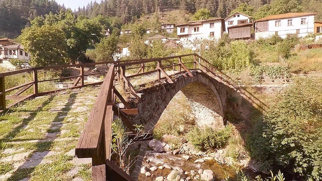
Devils Bridge - Ardino 28.1 km away. The Devil's Bridge (Dyavolski Most, in Turkish Sheytan Kyupriya) is located in the gorge of the Arda River, just north of the town of Ardino in Bulgaria. It was constructed in the early 16th century, between 1515 and 1518, by an architect named Dimitar, on the remains of an earlier Roman bridge.

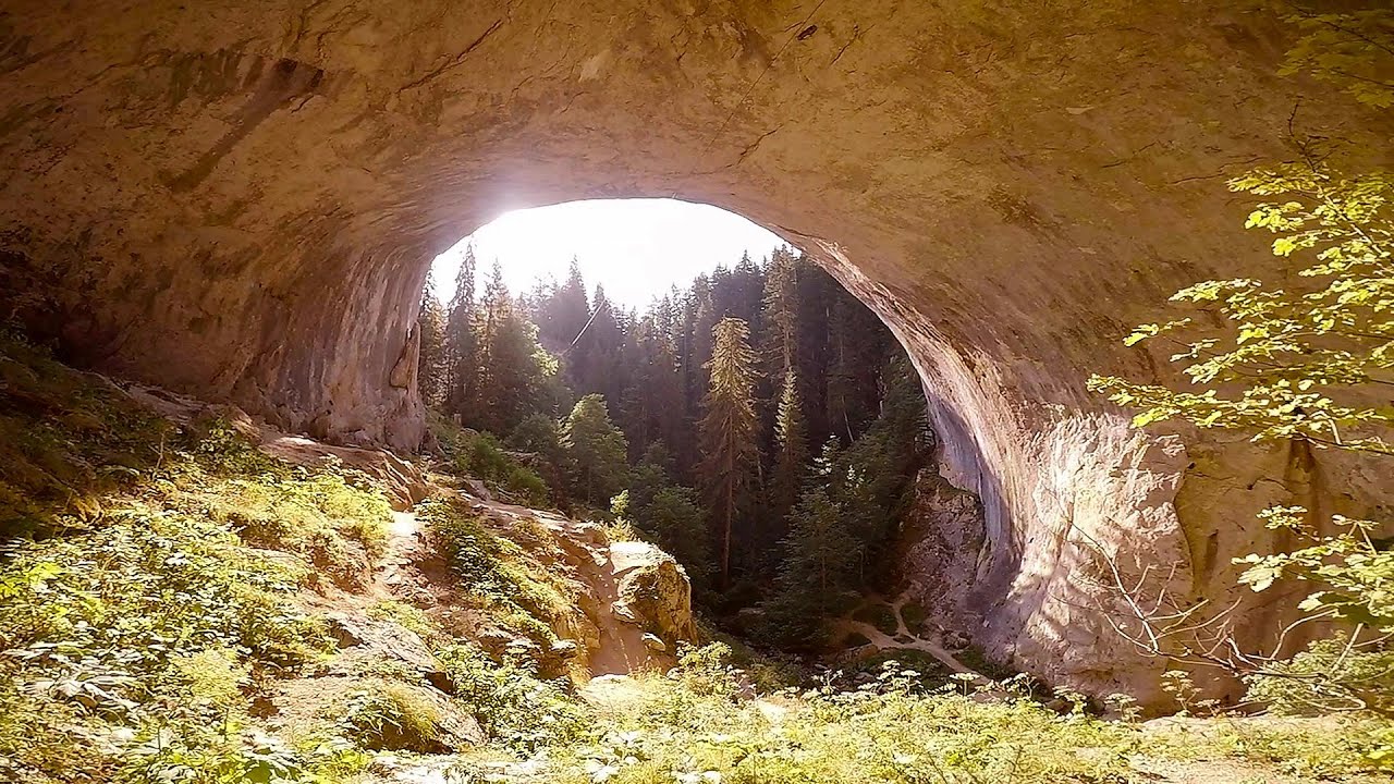
Vulva cave - Rhodope Mountains 28.2 km away. The Vulva Cave (Peshtera Utroba) is situated near the village of Nenkovo and the city of Kardzhali, in the Rhodope Mountains of Bulgaria. It derives its name from the shape of its entrance, which resembles a vulva.
Amazing Bridges - Zabardo 32.1 km away. The Amazing Bridges (Chudni Mostove, Wonderful Bridges) are natural stone bridges. They are located in the Rhodope Mountains, in the Smolyan Province of Bulgaria, within the valley of the Erkyupriya River, at an altitude of 1,450 meters above sea level.
Neviastata ecopath and iron path - Smolyan 36.2 km away. The Neviastata eco-trail is located in Bulgaria, nestled in the heart of the Rhodope Mountains, between Smolyan and Pamporovo. Here, you will find a small, paid adventure park.
Shiroka Laka village - Smolyan 36.9 km away. Shiroka Laka is one of the most beautiful villages in Bulgaria. It is located in the Rhodope Mountains, in the Smolyan province, in the southern part of the country.
Other places
Dino Parc Rasnov 418.2 km away. On June 12, 2015, one of the largest dinosaur theme parks in the region opened in Rasnov, where we can see 45 life-sized dinosaurs. The facility is located directly next to the Rasnov Fortress, which is one of the best-preserved Transylvanian Saxon peasant fortresses.
Abandoned Sports Hall Varna 288.6 km away. An abandoned sports hall in Varna, with an unfinished dormitory and tennis courts across three levels.
Sterp- and White creek valleys Ciucas Mountains 412.4 km away.
Borov Kamak waterfall Zgorigrad, Vratsa 188.1 km away. The Vratsa eco-trail starts from the village of Zgorigrad, located 6 km from the city of Vratsa in Bulgaria, and ends at the Parshevitza hut. It is also known as the Zgorigradska or Borov Kamak eco-trail.
Berim via ferrata Zubin Potok 378.2 km away. Difficulty level D, total length: 4 km, height difference: 520 m, year of construction: 2015. Climbing season: May 1 - October 30.
Kaya Bunar Hotnitsa 151.1 km away. The Kaya Bunar Waterfall (Hotnishki Vodopadi, Hotnitsa Waterfall) is located 20 km from the city of Veliko Tarnovo in Bulgaria. The waterfall is 30 meters high, and there are several smaller cascades above it.
Turcinovac via ferrata and cave Ovcar Banja 451.2 km away. Difficulty level B, total length: 60 m, height difference: 45 m, year of construction: 2010. Climbing the via ferrata is only permitted with the approval of the Extreme Sports Club Armadillo from Cacak, and there is a fee for it.
Poenari citadel Arges valley 390.7 km away. The Poenari citadel is located on the southern slope of the Fagaras Mountains, on the western side of the Transfagaras road, in the Arges Valley, about 4 km from the Vidraru Lake dam. Along a steep incline, a concrete staircase leads up to the castle, which is built atop a mountain.
Via ferrata Shpellat Peja 399 km away.
Skaklya waterfall Vratsa 188.4 km away. The largest seasonal waterfall in Bulgaria plunges down from a height of 141 meters. It is located in the Vratsa Mountain National Park, just one and a half kilometers away from the city of Vratsa.
Via ferrata Mat Peja 398.7 km away.
Oltet Gorge Capatana Mountains 385.4 km away. Oltet Gorge (Cheile Oltetului) - Capatana Mountains. That day, we had planned to ski at the Ranca resort, situated alongside the Transalpina high altitude mountain road in the Parang Mountains.
Boli Cave Banita 422.3 km away. The Boli Cave is located 6 km north of Petrosani, on the road that connects Hateg with the Jiu Valley. Here, the railway line that connects the two parts of Hunedoara County passes through, featuring a total of 66 curves and 8 tunnels.
Zip-line near Seven Ladder Canyon Piatra Mare Mountain 418.3 km away.
Womens Spiral, Cave Ridge, and The Great Crack iron paths Baia de Fier 384.5 km away. Perhaps the most interesting via ferrata among the routes in the Baia de Fier area is the Womens Spiral. After completing it, I can say that it is the second most thrilling via ferrata in Romania, following the Big Via Ferrata at Rasnov.
Other destinations
Parmak Kaya Nochevo, Panichkovo 16.9 km away. Between the villages of Nochevo and Panichkovo in Chernoochene Municipality, Kardzhali Province, lies Parmak Kaya (Finger Rock). The site features ancient carvings and rock formations within an old pine forest.
The two niches with the visor Nochevo 19.5 km away. Dvete nishi s kozirkata (The two niches with the visor) - Nochevo.
The Stone Path Nochevo 19.6 km away. Kamennata pateka (The Stone Path) - Nochevo.
Big Cave Nochevo 19.7 km away. Kodzha in (Golyamata Peshtera, Big Cave) - Nochevo.
[ Top ↑ ]
Copyright © 2003-2026 Trekkingklub and friends. Reproduction of any text, picture or video from this website, either in printed or electronic form, is prohibited without prior written permission.
The given distances are to be understood as straight line distances, and are approximate. Website made in Miercurea Ciuc  .
.