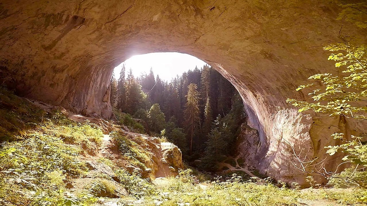
The Stone Path - Nochevo
Kamennata pateka (The Stone Path) - Nochevo.
Login (register) for the full descriptions, and access to the photos and videos.
Airport nearby: Plovdiv International Airport (PDV - Plovdiv, Bg), 36 km away.
Photos of nearby places


The Stone Wedding - Zimzelen (12 photos) 29.7 km away. The Stone Wedding (Kamenna_Svatba) - Zimzelen.

Canyon of Waterfalls eco-trail - Smolyan (8 photos) 57.2 km away. The Soskovcheto Reserve was established in 1968 and covers an area of 177 hectares. It is situated in the Perelishko-Prespanski region of the Rhodope Mountains.


Wonderful Rocks - Asparuhovo (24 photos) 210.2 km away. The Wonderful Rocks (Chudnite skali), a very beautiful and impressive rock formation, are located on the right bank of the Luda Kamchiya River, on the shores of the Tsonevo Reservoir and near the village of Asparuhovo. They have the shapes of pointed, tall cones and pyramids.

Castle of Ravadinovo (79 photos) 211.6 km away. The Castle of Ravadinovo (In love with the wind), situated near Sozopol in Bulgaria, is a enchanting structure that delights visitors with its fairytale-like appearance and distinctive charm. Also known as In Love with the Wind, this castle is the visionary project of architect Georgi Kostadinov Tumpalov, who dedicated himself to its design and construction from 1996 onward, transforming his dream into reality through perseverance and community support.

Seagulls beach and the Marina Port Sozopol harbour (2 photos) 213.9 km away. Marina Port Sozopol offers everything an experienced sailor could wish for. The port has 243 berths for boats up to 25 meters long, equipped with electricity and drinking water.

Drivers beach between Duni and Arkutino (6 photos) 214.2 km away. Drivers or Chauffeurs Beach, also known as Alepu Beach or Dunes, is one of the most renowned and scenic wild beaches along the South Black Sea coast. Located between Duni Resort to the north and Cape Humata to the south, the beach stretches nearly 3 kilometers in length and reaches a width of up to 70 meters.

Thracian Fortress Ranuli, Lions Head Rock (40 photos) 214.8 km away. Thracian Fortress Ranuli (Valchan's fortress) and the Lion's Head Rock. On Copper Ridge (Meden Rid), overlooking the Ropotamo River, the Thracian miner tribe Skirmiani constructed a fortress.

Abandoned building Perla 2 - Primorsko (24 photos) 215.3 km away. The abandoned building Perla 2 is located north of Primorsko, in the Stomoplo Bay area, nestled in a forest. The construction of the luxury complex Pearl-2 began in 1986, but the site was abandoned in the spring of 1990, and it became home to bats.
[ Top ↑ ]
Videos of nearby places

Vulva cave - Rhodope Mountains 19.7 km away. The Vulva Cave (Peshtera Utroba) is situated near the village of Nenkovo and the city of Kardzhali, in the Rhodope Mountains of Bulgaria. It derives its name from the shape of its entrance, which resembles a vulva.

Stone Mushrooms - Beli Plast 21.8 km away. The Stone Mushrooms (Kamenni Gabi) nature reserve in Bulgaria is situated east of the village of Beli Plast, along the road that connects Kardzhali to Haskovo. Spanning an area of 3 hectares, the reserve is home to several mushroom-shaped rock formations.

Devils Bridge - Ardino 29.5 km away. The Devil's Bridge (Dyavolski Most, in Turkish Sheytan Kyupriya) is located in the gorge of the Arda River, just north of the town of Ardino in Bulgaria. It was constructed in the early 16th century, between 1515 and 1518, by an architect named Dimitar, on the remains of an earlier Roman bridge.

The Stone Wedding - Zimzelen, Kardzhali 29.7 km away. The Stone Wedding (Kamenna Svatba, Petrified Wedding, Kardzhali Pyramids) is located near the village of Zimzelen, close to the city of Kardzhali, in the eastern part of the Rhodope Mountains in Bulgaria. This spectacular natural formation was declared a natural monument in 1974.
Amazing Bridges - Zabardo 51.6 km away. The Amazing Bridges (Chudni Mostove, Wonderful Bridges) are natural stone bridges. They are located in the Rhodope Mountains, in the Smolyan Province of Bulgaria, within the valley of the Erkyupriya River, at an altitude of 1,450 meters above sea level.
Other places
Downstream of the Izvorul Dorului creek Vanturis waterfalls 385.8 km away. Downstream of the Izvorul Dorului (Source of longing) creek - Vanturis waterfalls, Bucegi Mountains.
Gods bridge Vratsa 209.1 km away. Anyone who has been to Bulgaria may be familiar with the Prohodna Cave, affectionately known as the Eyes of God; the Devetashka Cave, illuminated by seven windows in its ceiling. And perhaps they have also seen the Wonderful Bridges in the Rhodope Mountains.
Middle Belt via ferrata route Baia de Fier 386.4 km away. Middle Belt (Spirala Medie) via ferrata route - Baia de Fier. In May 2018, two new via ferrata routes were inaugurated in Baia de Fier.
Crivadia Gorge 429.4 km away. The Crivadia Gorge is located next to the village of Crivadia, which belongs to Banita. Access is difficult, and the hike is made through the streambed, with water up to the waist at its narrowest point.
Prohodna cave Karlukovo 171.2 km away. The Prohodna cave nicknamed The Eyes of God is located in Bulgaria, in the Iskar Gorge, on one of the largest karst areas in Bulgaria, 2 km from the town of Karlukovo. It is essentially a 262-meter-long natural stone bridge, with a large (45 m high) and a small (35 m high) entrance.
Winds iron path Baia de Fier 386.5 km away. The Wind's iron path (Via ferrata Vanturilor, D) is the via ferrata route number 11 in the Baia de Fier - Polovragi area. The sign at the base of the route was installed on February 9, 2020.
Via ferrata Shpellat Peja 416.9 km away.
Stan Valley Canyon in winter 390.7 km away. The Stan Valley is a picturesque canyon, even in winter. In fact, when the stream is frozen and covered with a layer of snow, exploring the canyon becomes much quicker and easier.
Billy-goat lake, Closed Gates Retezat Mountains 429.8 km away. The most unique ridge trail of the Retezat Mountains is the Closed Gates.Below, at an altitude of 2070 m above sea level, is the Billy-goat lake.
Laura iron path Baia de Fier 386.2 km away. Laura iron path (E) - Baia de Fier.
Kaya Bunar Hotnitsa 143.3 km away. The Kaya Bunar Waterfall (Hotnishki Vodopadi, Hotnitsa Waterfall) is located 20 km from the city of Veliko Tarnovo in Bulgaria. The waterfall is 30 meters high, and there are several smaller cascades above it.
Arched stone bridge Rugova Canyon 420.6 km away. Arched stone bridge - Rugova Canyon (Gryka e Rugoves).
Upstream of the Izvorul Dorului creek Vanturis waterfalls 385.9 km away. Upstream of the Izvorul Dorului (Source of longing) creek - Vanturis waterfalls, Bucegi Mountains.
Sterp- and White creek valleys Ciucas Mountains 405.7 km away.
Deubels path Piatra Craiului Mountains 405.7 km away. Deubels path - Piatra Craiului Mountains (Kings Rock).
Other destinations
The two niches with the visor Nochevo 0.1 km away. Dvete nishi s kozirkata (The two niches with the visor) - Nochevo.
Big Cave Nochevo 0.2 km away. Kodzha in (Golyamata Peshtera, Big Cave) - Nochevo.
Thracian stone sharapani Nochevo 0.5 km away. Sharapani is a traditional stone container used by ancient Thracians for processing grapes in wine production. Two well-preserved sharapani containers are located about 200 meters apart.
Parmak Kaya Nochevo, Panichkovo 2.8 km away. Between the villages of Nochevo and Panichkovo in Chernoochene Municipality, Kardzhali Province, lies Parmak Kaya (Finger Rock). The site features ancient carvings and rock formations within an old pine forest.
[ Top ↑ ]
Copyright © 2003-2026 Trekkingklub and friends. Reproduction of any text, picture or video from this website, either in printed or electronic form, is prohibited without prior written permission.
The given distances are to be understood as straight line distances, and are approximate. Website made in Miercurea Ciuc  .
.