Prohodna cave - Karlukovo | Video


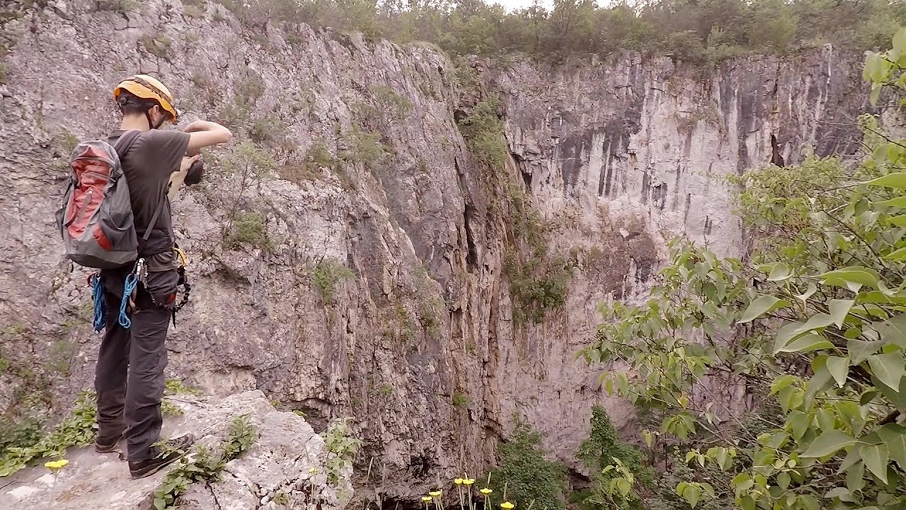
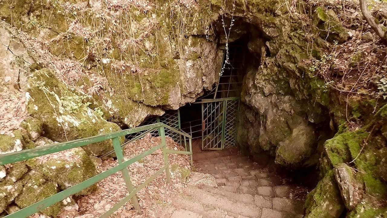
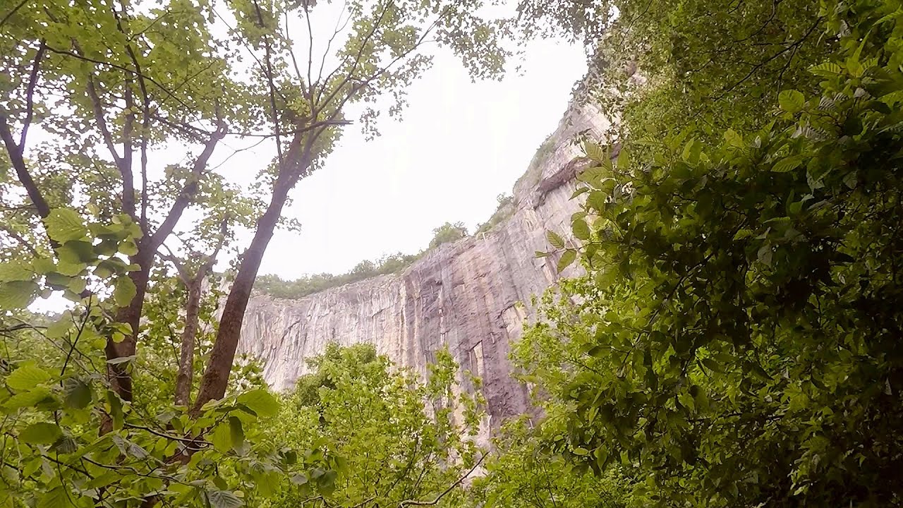
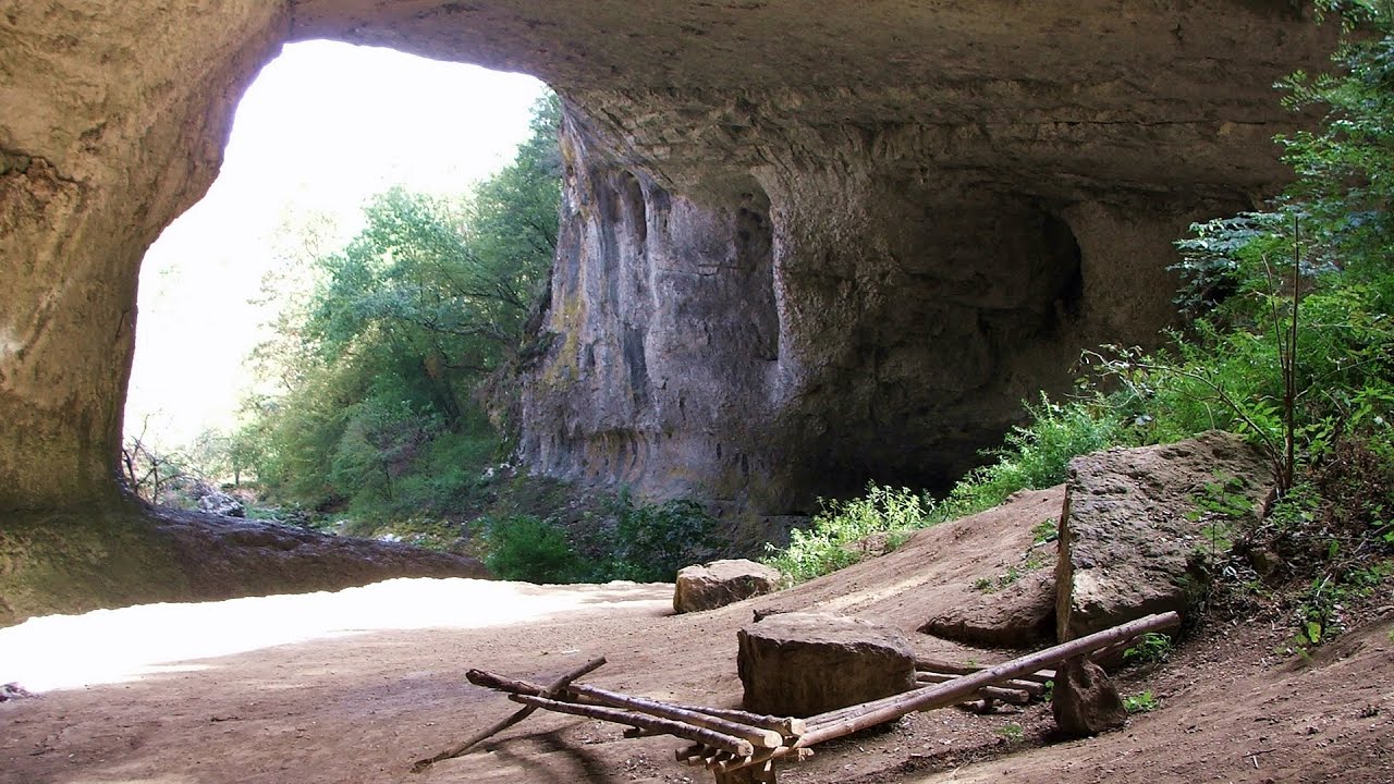
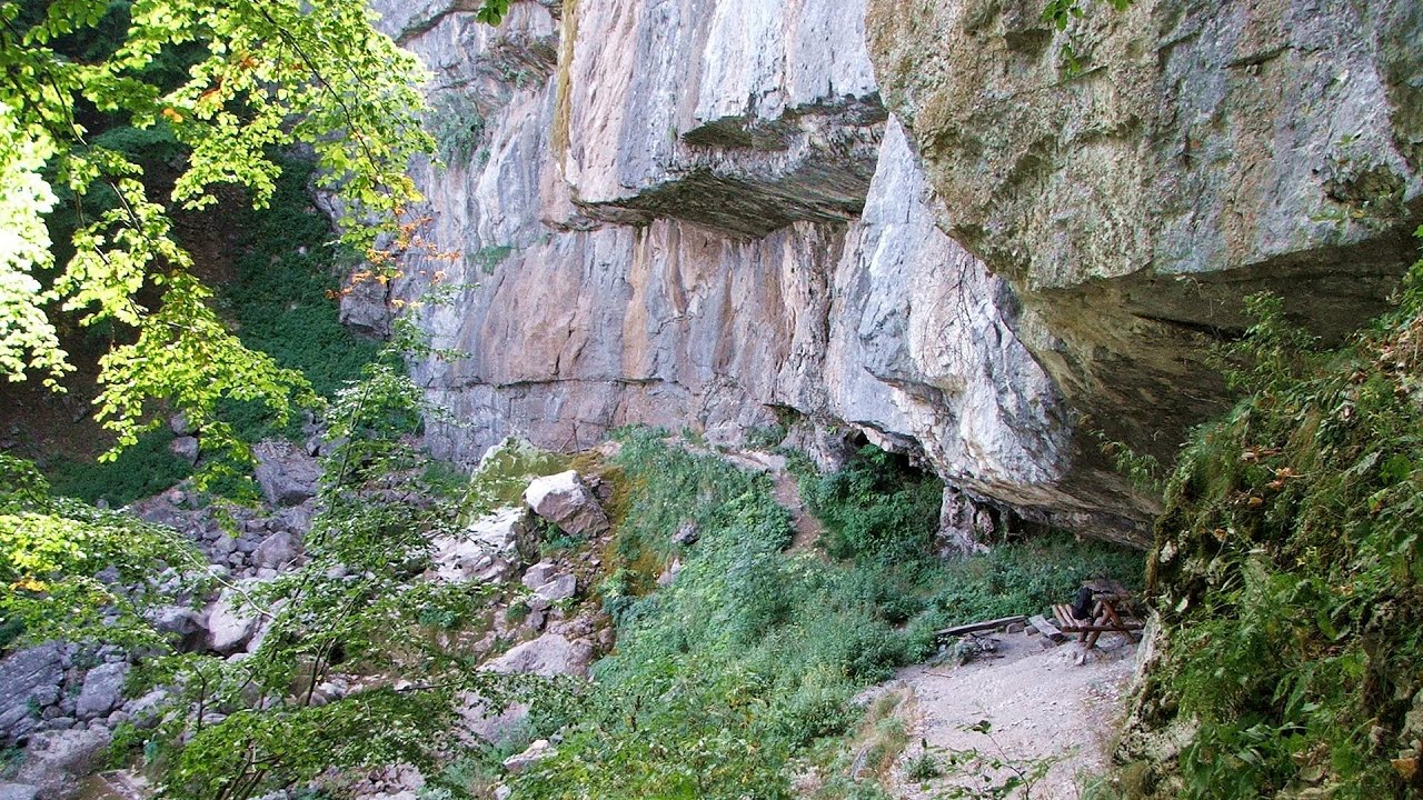
The Prohodna cave nicknamed The Eyes of God is located in Bulgaria, in the Iskar Gorge, on one of the largest karst areas in Bulgaria, 2 km from the town of Karlukovo. It is essentially a 262-meter-long natural stone bridge, with a large (45 m high) and a small (35 m high) entrance.
Read more
Filmed with GoPro HERO5 Black. Music: Daylight by Kai Engel. Copyright © 2017 - 2026 Geo Trekker Videos. Please register for full and ad-free access.
Airport nearby: Sofia Airport (SOF - Sofia, Bg), 75 km away.
Photos of nearby places


Canyon of Waterfalls eco-trail - Smolyan (8 photos) 182.7 km away. The Soskovcheto Reserve was established in 1968 and covers an area of 177 hectares. It is situated in the Perelishko-Prespanski region of the Rhodope Mountains.


The Stone Wedding - Zimzelen (12 photos) 200.9 km away. The Stone Wedding (Kamenna_Svatba) - Zimzelen.


Womens Cave - Parang Mountains (11 photos) 225.7 km away. The Cave of Women (Pestera Muierii, Pestera Muierilor) is located at the southern foot of the Parang Mountains, in the area of Baia de Fier in Gorj County. There are several climbing routes established on the rocks above the cave and on the other side of the road.


Ledge path of the chamois - Cheii Gorge (40 photos) 233.2 km away. Ledge path of the chamois (Brana Caprelor) - Cheii Gorge (Cheile Cheii).
[ Top ↑ ]
Videos of nearby places
Lednica iron path - Brestnitsa 16.8 km away. The Lednica via ferrata is located next to the Saeva Dupka Cave, near the village of Brestnitsa in Bulgaria. The trail leading to the via ferrata, which opened in 2007, starts from the cave parking lot next to a covered resting area.
Saeva Dupka cave - Brestnitsa 16.9 km away. The Saeva Dupka Cave is located 2 km south of the village of Brestnitsa. In its five chambers and 400 meters of passageways, you can see the most beautiful cave formations in Bulgaria.
Skaklya waterfall - Vratsa 42.5 km away. The largest seasonal waterfall in Bulgaria plunges down from a height of 141 meters. It is located in the Vratsa Mountain National Park, just one and a half kilometers away from the city of Vratsa.
Gods bridge - Vratsa 45.1 km away. Anyone who has been to Bulgaria may be familiar with the Prohodna Cave, affectionately known as the Eyes of God; the Devetashka Cave, illuminated by seven windows in its ceiling. And perhaps they have also seen the Wonderful Bridges in the Rhodope Mountains.
Borov Kamak waterfall - Zgorigrad, Vratsa 46.3 km away. The Vratsa eco-trail starts from the village of Zgorigrad, located 6 km from the city of Vratsa in Bulgaria, and ends at the Parshevitza hut. It is also known as the Zgorigradska or Borov Kamak eco-trail.
Other places
Cherven, a medieval fortified town Bulgaria 165.1 km away. Located about 30 km south of the city of Ruse in Bulgaria, the Cherven medieval fortress can be found in the Rusenski Lom Nature Park. Originally a Byzantine fortification from the 6th century, it reached the height of its development in the 14th century.
Ski Gyimes ski slope Lunca de Sus 400.5 km away. The Ski Gyimes ski slope is located in Lunca de Sus, right next to the main road. It is 800 m long, the level difference is 160 m.
Buzludzha monument Kazanluk 118 km away. Buzludzha is a historically significant mountain located in the Central Balkan Mountains of Bulgaria. At its summit, at an altitude of 1432 meters above sea level, there is an abandoned monument.
Amazing Bridges Zabardo 156.3 km away. The Amazing Bridges (Chudni Mostove, Wonderful Bridges) are natural stone bridges. They are located in the Rhodope Mountains, in the Smolyan Province of Bulgaria, within the valley of the Erkyupriya River, at an altitude of 1,450 meters above sea level.
Via ferrata Peja 360 Peja 317 km away.
Doabra Stones Brezoi, Lotru Mountains 242.8 km away. The DN7A road branches off west from the Olt Valley, from the main road between Sibiu and Ramnicu Valcea, leading towards Voineasa and Lake Vidra. The first settlement is a small town, Brezoi, which is located at the confluence of the Lotru and Olt rivers.
Clocota waterfall Geoagiu-Bai, Metaliferi Mountains 315.4 km away.
Dóczi stone-quarry Jigodin 377.4 km away.
Kaya Bunar Hotnitsa 116.9 km away. The Kaya Bunar Waterfall (Hotnishki Vodopadi, Hotnitsa Waterfall) is located 20 km from the city of Veliko Tarnovo in Bulgaria. The waterfall is 30 meters high, and there are several smaller cascades above it.
Black Rocks iron path Bihor Mountains 388.6 km away. Black Rocks is located in the Bihor Mountains, near the Vartop Saddle, to the west of it. It is interesting that the locals (if I understood correctly) do not know this name, but use the name Piatra Buna (meaning Good Stone) for this spectacular rock.
Dino Parc Rasnov 290.8 km away. On June 12, 2015, one of the largest dinosaur theme parks in the region opened in Rasnov, where we can see 45 life-sized dinosaurs. The facility is located directly next to the Rasnov Fortress, which is one of the best-preserved Transylvanian Saxon peasant fortresses.
Neviastata ecopath and iron path Smolyan 182.7 km away. The Neviastata eco-trail is located in Bulgaria, nestled in the heart of the Rhodope Mountains, between Smolyan and Pamporovo. Here, you will find a small, paid adventure park.
Searching for rhododendrons Ciucas Boulevard 299.3 km away. Red Mountain (Muntele Rosu), Gropsoarele-Zaganu ridge - Ciucas Mountains
The Trovants Museum in Winter Costesti 218.2 km away.
Drina river house Bajina Bašta 374 km away. The house visible on the Drina River (Kućica na Drini) is a unique wooden structure built on a rock in the middle of the river, near Bajina Bašta, Serbia. The house is located on the border between Serbia and Bosnia-Herzegovina, close to the border line between the two countries.
Other destinations
Natural stone bridge Aglen 19.8 km away. Natural stone arch on the Vit river, near the village of Aglen. Crocodile shaped rock, Elephant rock.
Abandoned copper mine Tsar Asen, Pazardzhik 93.4 km away. The turquoise waters of this mine lake are extremely beautiful but dangerously poisonous. Do not descend to the shore or touch the water!
Belintash Ridge of Dobrostan, Rhodope Mountains 164.7 km away. Belintash is a mysterious monolithic complex located approximately 50 km from Plovdiv, passing through the scenic Rhodope Mountains. It is situated southeast of the village of Vrata and west of the village of Sini Vruh.
Parmak Kaya Nochevo, Panichkovo 170.9 km away. Between the villages of Nochevo and Panichkovo in Chernoochene Municipality, Kardzhali Province, lies Parmak Kaya (Finger Rock). The site features ancient carvings and rock formations within an old pine forest.
[ Top ↑ ]
Copyright © 2003-2026 Trekkingklub and friends. Reproduction of any text, picture or video from this website, either in printed or electronic form, is prohibited without prior written permission.
The given distances are to be understood as straight line distances, and are approximate. Website made in Miercurea Ciuc  .
.