Cherven, a medieval fortified town - Bulgaria | Video


Located about 30 km south of the city of Ruse in Bulgaria, the Cherven medieval fortress can be found in the Rusenski Lom Nature Park. Originally a Byzantine fortification from the 6th century, it reached the height of its development in the 14th century.
Read more
Filmed with GoPro HERO5 Black. Music: Epoch by Jon Luc Hefferman. Copyright © 2017 - 2026 Geo Trekker Videos. Please register for full and ad-free access.
Airport nearby: Gorna Oryahovitsa Airport (GOZ - Gorna Oryahovitsa, Bg), 58 km away.
Photos of nearby places

Wonderful Rocks - Asparuhovo (24 photos) 126 km away. The Wonderful Rocks (Chudnite skali), a very beautiful and impressive rock formation, are located on the right bank of the Luda Kamchiya River, on the shores of the Tsonevo Reservoir and near the village of Asparuhovo. They have the shapes of pointed, tall cones and pyramids.


Replica of the Eiffel Tower and Arc de Triomphe - Sveti Vlas (5 photos) 172.4 km away. Small-sized replica of the Eiffel Tower and Arc de Triomphe, in front of the decorative pool at the Romance Paris luxury hotel complex, in Sveti Vlas (Saint Blaise) resort.

UNESCO World Heritage Site: Nesebar, the pearl of the Black Sea (20 photos) 175.2 km away. Nesebar is an ancient Bulgarian city on the Black Sea Coast, today a UNESCO World Heritage Site. It is renowned for its over three thousand years of history, diverse cultural heritage, and well-preserved medieval monuments.


Seagulls beach and the Marina Port Sozopol harbour (2 photos) 190.5 km away. Marina Port Sozopol offers everything an experienced sailor could wish for. The port has 243 berths for boats up to 25 meters long, equipped with electricity and drinking water.

Castle of Ravadinovo (79 photos) 191.9 km away. The Castle of Ravadinovo (In love with the wind), situated near Sozopol in Bulgaria, is a enchanting structure that delights visitors with its fairytale-like appearance and distinctive charm. Also known as In Love with the Wind, this castle is the visionary project of architect Georgi Kostadinov Tumpalov, who dedicated himself to its design and construction from 1996 onward, transforming his dream into reality through perseverance and community support.


[ Top ↑ ]
Videos of nearby places

Kaya Bunar - Hotnitsa 67.2 km away. The Kaya Bunar Waterfall (Hotnishki Vodopadi, Hotnitsa Waterfall) is located 20 km from the city of Veliko Tarnovo in Bulgaria. The waterfall is 30 meters high, and there are several smaller cascades above it.
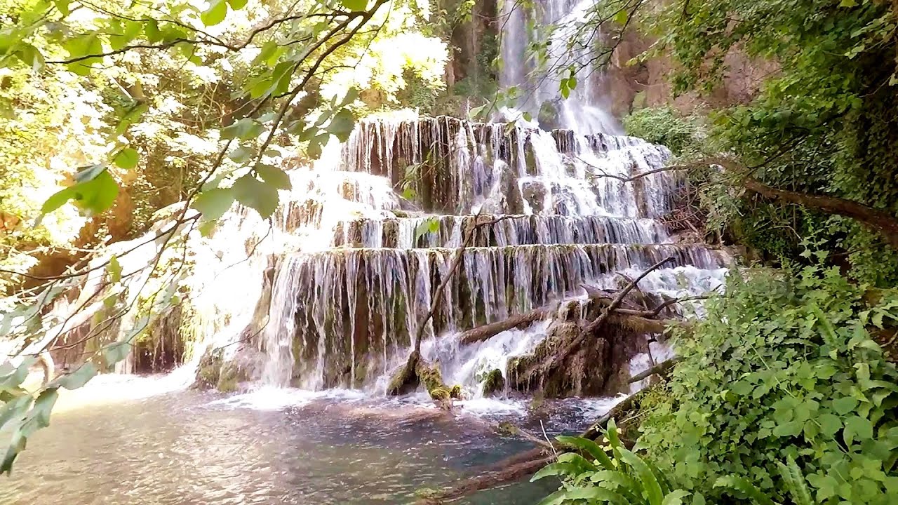
Krushuna waterfalls - Krushuna 90.3 km away. The Krushuna Waterfalls are a series of karst cascades formed in travertine. They are located near the village of Krushuna, not far from the town of Lovech, and are Bulgaria's largest waterfall of this type.
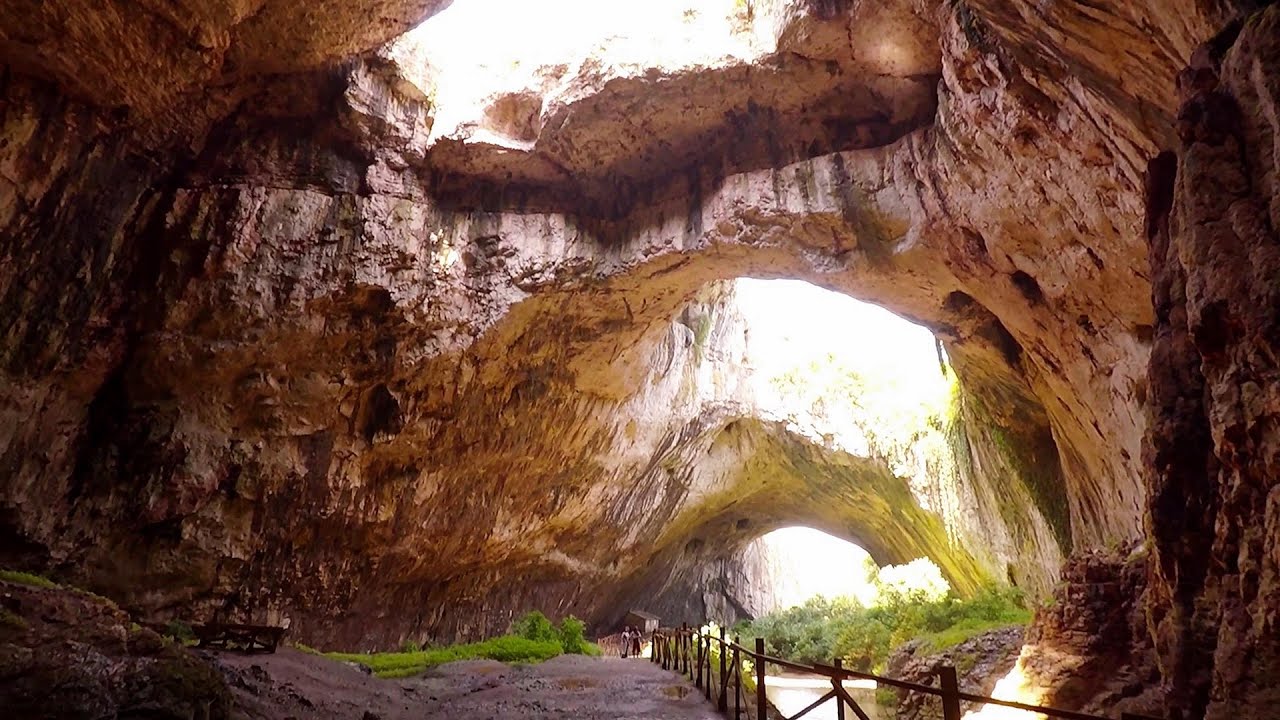
Devetashka cave - Devetaki 101.6 km away. The Devetashka Cave is located in Bulgaria, near the village of Devetaki. After the entrance portal, which measures 30 m by 35 m, there is a vast open chamber that is 110 meters wide and 359 meters long.

Buzludzha monument - Kazanluk 111.1 km away. Buzludzha is a historically significant mountain located in the Central Balkan Mountains of Bulgaria. At its summit, at an altitude of 1432 meters above sea level, there is an abandoned monument.

Shipka pass - Shipka 112.7 km away. The Shipka Pass is one of the most spectacular crossings of the Balkan Mountains, and is part of the Bulgarka Nature Park. It separates the provinces of Gabrovo and Stara Zagora, and provides a connection between the cities of Gabrovo and Kazanlak.
Other places
Canyon of Waterfalls Smolyan 253.6 km away. The eco-trail known as the Canyon of Waterfalls is located in Bulgaria, within the Rhodope Mountains and the Soskovcheto Nature Reserve. It begins at the edge of the Sredoka suburb of the city of Smolyan.
Shiroka Laka village Smolyan 246.2 km away. Shiroka Laka is one of the most beautiful villages in Bulgaria. It is located in the Rhodope Mountains, in the Smolyan province, in the southern part of the country.
Small Via ferrata Rasnoavei Gorge 217.5 km away. In the past few days, it has snowed, so I climbed the two climbing routes in the Rasnoavei Gorge under winter conditions. While the lower part of the challenging Big via ferrata was dry, the upper section had patches of snow and icicles.
Ski resort Poiana Brasov Postavarul Mountains 219.8 km away. Shining sun and an Austria-feeling on the impeccable slopes of the ski paradise Poiana Brasov above Brasov. Sunbathing, coffee and refreshing drinks on the terrace of Julius Römer chalet.
Nobodys lake Miercurea Ciuc 304.2 km away. The passage of time (time lapse), dusk at Nobody's Lake. Miercurea Ciuc and the Sumuleu mountain can be seen in the background.
Eagles Eye Yagodina 259.7 km away. Orlovo Oko (Eagle's Eye) is a lookout viewpoint located in the Rhodope Mountains, near the peak of Saint Ilia and close to the village of Yagodina, Bulgaria. The steel structure, built at an altitude of 1,563 meters, rises 670 meters above the spectacular Buynovsko Gorge, along with the winding river and road that traverse it.
Abandoned copper mine Tsar Asen, Pazardzhik 196.4 km away. The turquoise waters of this mine lake are extremely beautiful but dangerously poisonous. Do not descend to the shore or touch the water!
Bicajel Gorge, Bicajel Waterfall, Stone of the Gorge 355 km away. Bicajel Gorge (Cheile Bicajelului), Bicajel Waterfall (Cascada Bicajel), Stone of the Gorge (Surduc Stone, Piatra Surducului) - Hasmas Mountains.
Hot air balloon parade 2015 Campu Cetatii 347.8 km away. This year, the Hot Air Balloon Parade was organized in Campu Cetatii for the tenth time. Unfortunately, the weather only allowed for flying on Saturday morning and evening.
Via ferrata Shpellat Peja 480.6 km away.
Poenari citadel Arges valley 221.6 km away. The Poenari citadel is located on the southern slope of the Fagaras Mountains, on the western side of the Transfagaras road, in the Arges Valley, about 4 km from the Vidraru Lake dam. Along a steep incline, a concrete staircase leads up to the castle, which is built atop a mountain.
The Wooden Ladders The villages of Scarisoara and Inelet, Cerna valley 316.8 km away. Scarisoara and Inelet are small, isolated villages located in the mountainous region of Banat. They are situated on the right bank of the Cerna River, approximately 19 km away from the Baile Herculane resort.
Deubels path Piatra Craiului Mountains 221.4 km away. Deubels path - Piatra Craiului Mountains (Kings Rock).
Devils Mill Gorge Campulung Moldovenesc 429.4 km away. The Devil's Mill Gorge is relatively short, measuring only 60 to 70 meters in length. It was formed in yellowish-gray-white dolomite by the work of a stream that crosses the gorge, as a result of erosion and the dissolution characteristic of limestone.
Other destinations
Natural stone bridge Aglen 145.7 km away. Natural stone arch on the Vit river, near the village of Aglen. Crocodile shaped rock, Elephant rock.
Abandoned Sports Hall Varna 162.8 km away. An abandoned sports hall in Varna, with an unfinished dormitory and tennis courts across three levels.
Abandoned copper mine Tsar Asen, Pazardzhik 196.4 km away. The turquoise waters of this mine lake are extremely beautiful but dangerously poisonous. Do not descend to the shore or touch the water!
[ Top ↑ ]
Copyright © 2003-2026 Trekkingklub and friends. Reproduction of any text, picture or video from this website, either in printed or electronic form, is prohibited without prior written permission.
The given distances are to be understood as straight line distances, and are approximate. Website made in Miercurea Ciuc  .
.