Rhein Gorge - Flims, Switzerland | Video


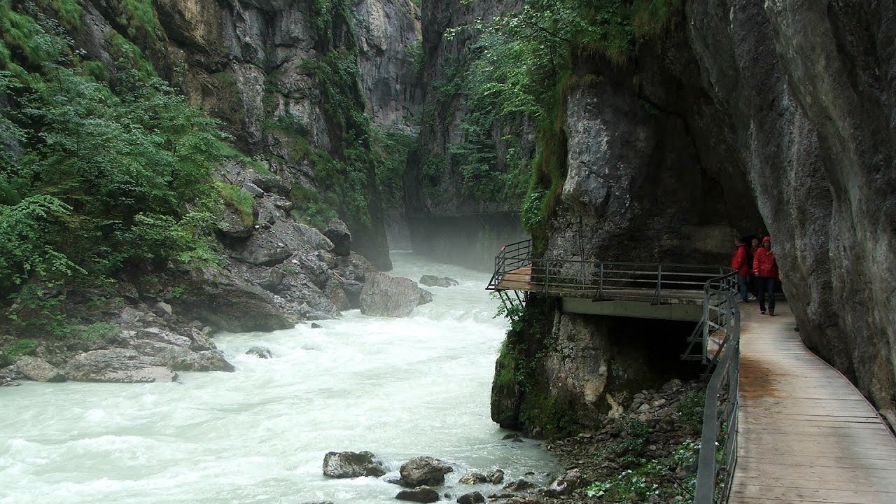
The Rhine River (in German, Rhein) originates in the Swiss canton of Graubünden at the Oberalppass and flows into the North Sea at Rotterdam in the Netherlands after traveling 1,324 km. The Rhine Gorge, also known as the Swiss Grand Canyon (in Romansh, Ruinaulta), winds for 14 km between 350 m high white walls.
Read more
Filmed with GoPro HERO5 Black. Music: Daedalus by Kai Engel. Copyright © 2017 - 2026 Geo Trekker Videos. Please register for full and ad-free access.
Airport nearby: Samedan Airport (SMV - Samedan, Ch), 53 km away.
Photos of nearby places

Venice - Italy (60 photos) 278.6 km away. Venice (Venezia) is a city located in northeastern Italy, it is the capital of the region of Veneto. It is known for its unique setup of being built on a lagoon, on a group of islands separated by canals and connected by bridges.

Kanin cableway and ski resort - Shooting window, Monte Forato, Bovec, Sella Nevea (48 photos) 321.1 km away. The Kanin Mountains are located in the Western Julian Alps, on the border of Slovenia and Italy. The highest peak in this range, known as (High) Kanin or Monte Canin Alto, in Slovenian and Italian respectively, reaches a height of 2,587 m above sea level.

Boka Waterfall - Slovenia (11 photos) 322.8 km away. Boka (Slap Boka) is a waterfall in western Slovenia, near the Soca River. It has two stages, with the first being 106 m high and 18 m wide, and the second being 33 m high.

Napoleon Bridge - Kobarid, Slovenia (22 photos) 332.3 km away. The Napoleon bridge (Napoleonov most) is located near Kobarid, on the banks of the Soca (Isonzo) river. The bridge has existed since ancient times, and has undergone multiple demolitions and reconstructions.

Slap Kozjak waterfall - Slovenia (24 photos) 332.3 km away. Slap Kozjak waterfall, perhaps the most beautiful waterfall in Slovenia, is situated near Kobarid. Located within the Kozjak stream gorge, and overlooking the stunning emerald green Soca River, this magnificent waterfall cascades 15 meters high, and is enclosed within a mesmerizing stone chamber.

Slap Savica waterfall - Slovenia (12 photos) 347.1 km away. Slap Savica, found in the northwestern part of Slovenia, is a magnificent, 78 m high waterfall. It derives its water from a karst spring called Savica located just above the falls.

Vogel Ski Resort - Slovenia (33 photos) 351.1 km away. Vogel Ski Resort is situated in Slovenia, above Bohinj and adjacent to Lake Bohinj, on the outskirts of Triglav National Park. The resort derives its name from the nearby Mount Vogel, and was established in 1964.

Lake Bohinj - Upper Carniola, Slovenia (10 photos) 354 km away. Lake Bohinj, also known as Bohinjsko jezero in Slovene and Wocheiner See in German, is the biggest permanent lake in Slovenia, covering a vast area of 318 hectares. Situated in the Bohinj Valley of the Julian Alps, in the northwestern region of Upper Carniola (Gorenjska, Alta Carniola, Oberkrain), it forms a part of the Triglav National Park.

Skocjan Caves - Slovenia (22 photos) 381.1 km away. The Skocjan Caves (Skocjanske jame) are a system of underground caves located in the Karst region of Slovenia. These caves are famous for their breathtaking natural beauty, and extensive underground river system.

Predjama Castle - Slovenia (54 photos) 385.4 km away. Predjama Castle built onto a cave, is situated on a cliff, in the village of Predjama, Slovenia. The castle has a rich history dating back to the 13th century.

Postojna Cave - Slovenia (12 photos) 392.2 km away. The Postojna Cave (Postojnska jama) is a renowned tourist attraction located in Slovenia. It is a network of underground galleries and halls, stretching over 24 kilometers, known for its geological formations, including stalagmites and stalactites.

Old town Krk - Krk Island, Croatia (11 photos) 452.4 km away. Krk is a Croatian island located in the Adriatic Sea. It is the largest island in the country, and has a rich history dating back to ancient times.
[ Top ↑ ]
Videos of nearby places
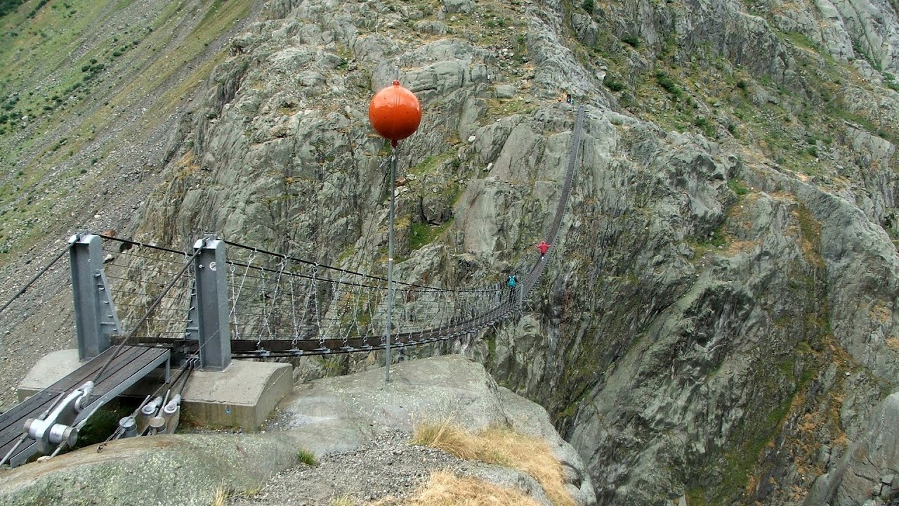
Trift valley, bridge, lake and glacier - Gadmen, Switzerland 74.5 km away. During the hike in Trift Valley, I experienced cloudy and gloomy weather with intermittent rain. Here is the 170 m long Trift Bridge, the longest pedestrian suspension bridge in the Swiss Alps, in a breathtaking environment, 100 meters above the Trift Glacier Lake.
Handeckfallbrücke, Gelmerbahn, Gelmersee - Schweiz 79.3 km away. Although the path from the Gelmerbahn parking bypasses the Handeckfall waterfall, it is worth descending a few steps from the valley station of the funicular, to reach Handeckfallbrücke. A 70-meter long suspension bridge that hangs 70 meters above the gorge, offering a spectacular view of the waterfall.
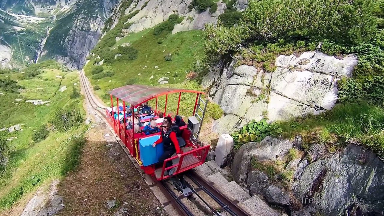
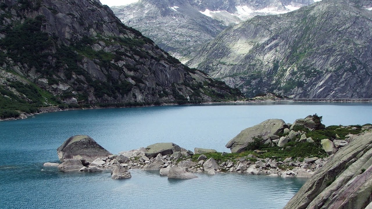
Gelmerbahn - Guttannen, Schweiz 80.2 km away. The Gelmerbahn in Switzerland is the steepest open funicular in Europe. It transports tourists from an altitude of 1412 meters to over 1860 meters above sea level, as well as to the Gelmer lake located at 1849 meters.
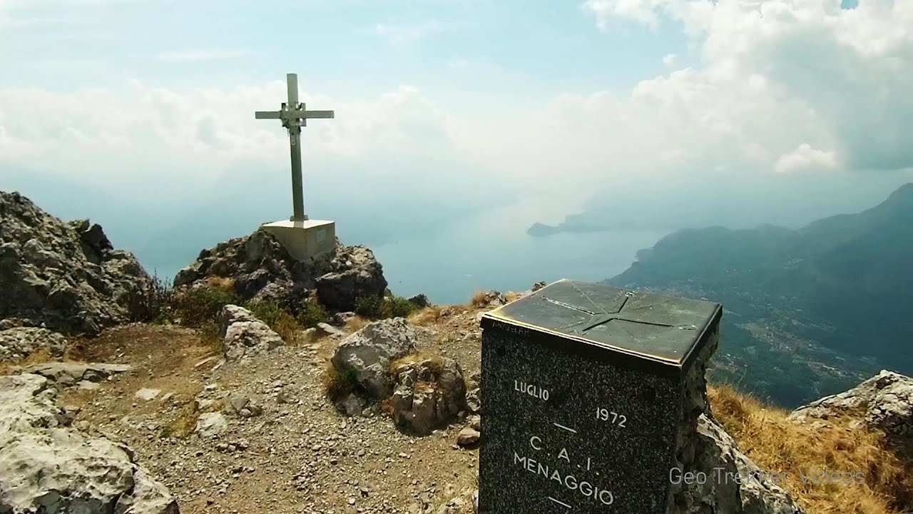
Via Ferrata Centenario C.A.O - Monte Grona, Prealpi Lombarde, Lombardia 83.9 km away. In the magnificent rocky world of Monte Grona, the Centenario via ferrata leads upwards, which I had the opportunity to climb accompanied by lizards. Although it was cloudy and gloomy, I had a great view of Lake Lugano and Lake Como along the way.
Aareschlucht - Meiringen-Innertkirchen, Switzerland 84.8 km away. The Aareschlucht is a 1400-meter long, 200-meter deep gorge of the Aare river, near Innertkirchen, Switzerland. It has two entrances, one from Meiringen in the west, and one from Innertkirchen in the east, which lead into the narrow, but stunning gorge.
Other places
Giant Ice Cave Dachstein Salzkammergut, Obertraun am Hallstättersee 342 km away. The second cave accessible to the public at the Schönbergalm above Obertraun on Lake Hallstatt is the Giant Ice Cave (Rieseneishöhle). For me, it was more spectacular than the Mammoth Cave.
The Crack Grohmanns Ledge Monte Pelmo 219.3 km away. Monte Pelmo is nicknamed God's Armchair because its shape resembles a huge armchair. Between Monte Pelmo and Monte Pelmetto is The Crack (La Fessura).
Via ferrata Adventure Climb Varmost Forni di Sopra, Cima Clap Varmost, Alpi Carniche 251.3 km away. I participated in a joint, Szekler-Italian 'military exercise' :-) on the Adventure Climb Varmost via ferrata. The iron climbing route is located in the Friuli-Venezia Giulia region, in the Carnic Alps, and it leads up to the summit of Clap Varmost above Forni di Sopra.
Play Wall via ferrata park Mariazeller via ferrata, Felixs Ladder to the Heaven, Devils Bridge 463.1 km away. Located only ten kilometers from the town of Mariazell, you'll find the via ferrata park known as the Play Wall (Klettersteigpark Spielmäuer). Here, we find three via ferratas: Olivers Mariazeller Steig (B/C), Felix Himmelleiter (D), and Tristans Kirchbogensteig (C).
Kaiser Franz-Josef Klettersteig Leopoldsteiner See 426.3 km away. The Franz-Josef Klettersteig is located on the Seemauer cliff face, which rises 900 meters above Leopoldsteiner Lake, in the western part of the Hochschwab mountain range, just 4 km from the town of Eisenerz. This via ferrata is named after the Kaisersteig, a hunting trail established for the esteemed Emperor Franz Joseph I of Austria and Hungary at the end of the 19th century, traces of which can still be observed today.
Sky Walk, Suspension Bridge, Stairway to Nothingness Styria, Dachstein 333.6 km away. The Dachstein cable car (Gletscherbahn Panorama Gondel, Panorama Cable Car) took me up to a height of 2700 meters, to the highest mountain in Styria (Steiermark), the Dachstein. Next to the upper station of the cable car there are several tourist attractions.
Via ferrata Ernesto Che Guevara al Monte Casale, Monti del Garda, Trentino Alto Adige 152 km away. The Che Guevara via ferrata is the longest iron climbing route I have ever climbed. There is a 1400 m level difference from the starting point to the peak of Monte Casale.
Siega via ferrata Silberkar Gorge, Ramsau am Dachstein 339.4 km away. The Siega via ferrata, categorized as a C/D level of difficulty, is perhaps the least interesting of the three via ferrata routes in the Silberkar Gorge (Silberkarklamm). This doesn't mean that it's not good, just that the other two are even better.
Leopoldsteiner lake Eisenerz, Steiermark 426.8 km away. Leopoldsteiner See is located in Styria, 4 km northwest of the town of Eisenerz. It lies at an elevation of 628 meters above sea level in the western part of the Hochschwab mountain range, at the foot of the Seemauer cliff.
Kaiserschild Klettersteig Eisenerzer Ramsau 423.6 km away. The 2,085-meter-high Kaiserschild peak is situated on the northern edge of the Eisenerz Alps in Styria, Austria. It forms a double summit with the slightly taller Hochkogel peak, which stands at 2,105 meters.
Silberkar Gorge Ramsau am Dachstein 339.7 km away. One of the most beautiful hiking spots in the area of Ramsau am Dachstein, is the Silberkarklamm (Silberkar Gorge). It is possible to drive to the entrance of the gorge, there is parking available on the side of the road, and you have to pay an entrance fee.
Mammoth Cave Dachstein Salzkammergut, Obertraun am Hallstättersee 341.3 km away. The first station of the Dachstein Krippenstein cable car, which starts in Obertraun, in the southern part of Lake Hallstatt, is Schönbergalm. Here you can find the Giant Ice Cave (Rieseneishöhle) and the Mammoth Cave (Mammuthöhle).
The Devils Iron Path Aussois, Savoy, Rhône Alps 267.3 km away. The Devil's Iron Path (Via ferrata du Diable) is a multi-part via ferrata, located above a spectacular waterfall (Cascade du Nant), in a gorge, below the Victor-Emmanuel fort. For me, this climbing route presented the greatest challenge so far (2015).
Five Fingers, World NATURE Heritage Lookout, World Heritage Spiral, Dachstein Shark 339.8 km away. The second station of the cable car departing from Obertraun is the Krippenstein peak (2100 m). Here you can find the famous Five Fingers (5fingers) lookout, which offers a unique view of Hallstatt and Obertraun below, as well as the Hallstättersee lake.
Via ferrata Rio Sallagoni Drena, Italia 155.3 km away. The surrounding iron climbing routes are located on rock walls exposed to a scorching sun. But the Rio Sallagoni via ferrata goes upwards in a pleasantly cool gorge, above the creek and waterfalls, and eventually reaches the Drena Castle.
[ Top ↑ ]
Copyright © 2003-2026 Trekkingklub and friends. Reproduction of any text, picture or video from this website, either in printed or electronic form, is prohibited without prior written permission.
The given distances are to be understood as straight line distances, and are approximate. Website made in Miercurea Ciuc  .
.