Abandoned building Perla 2 - Primorsko | Photos
Hiking photos and videos Login Register
Select language: - Magyar - Romana - Deutsch - Français - Italiano - Español -
Select language: - Magyar - Romana - Deutsch - Français - Italiano - Español -


Page no. 1, photos: 1-10, 24 photos in total. >>>

The abandoned building Perla 2 is located north of Primorsko, in the Stomoplo Bay area, nestled in a forest. The construction of the luxury complex Pearl-2 began in 1986, but the site was abandoned in the spring of 1990, and it became home to bats.
Read more
Copyright © 2025 Trekkingklub.com.
Already published 8983 photos and 180 videos. Please register for full and ad-free access.
Photos of nearby places

The home of the mermaid - Primorsko (6 photos) 1.2 km away
A human-sized mermaid statue, weighing 800 kg, is lying on the seabed. It is located near the Small Crocodile Islet, south of the underwater chapel, at a depth of 12 meters next to a vertical cliff.

Saint Nicholas (Sveti Nikolai) underwater chapel - Primorsko (6 photos) 1.2 km away
The Saint Nicholas (Sveti Nikolai) underwater chapel is located southwest of Crocodile Rock, behind Little Crocodile Island, at a depth of 6 meters. The chapel was installed on June 1st, 2013.

Crocodile Rock - Primorsko (22 photos) 1.34 km away
North of Primorsko, along the rocky coastline of the Black Sea, there are stunning cliffs and several rocky outcrops emerging from the water. Due to their unique shapes, these formations have been whimsically named Crocodile Rocks.

Underwater seal cave - Primorsko (6 photos) 1.61 km away
The Underwater Seal Cave is part of the underwater park located north of Primorsko. It is situated northeast from Crocodile Rock, also known as Big Crocodile Island.

Dragon House dolmen (Zmeyova Kashta) (5 photos) 2.5 km away
The dolmen Zmeyova Kashta (Dragon's House) is located very close to the asphalt road, near the Begliktash parking area, at the beginning of the trail to the Thracian fortress Ranuli. It is a small rectangular structure made of large stone blocks.

Portraits on the rocks - Primorsko Promenade and Lighthouse (12 photos) 2.61 km away
A wide seaside promenade that connects the northern and southern beaches of Primorsko. Along the promenade, on the rocks by the sea, the colorful images of famous personalities have been drawn.

Mermaid - Primorsko (8 photos) 2.69 km away
The statue of the mermaid is situated at the tip of the peninsula extending east of Primorsko. Elevated above the promenade on a rocky hillside, it occupies a highly visible location.

[ Top ↑ ]
Videos of nearby places
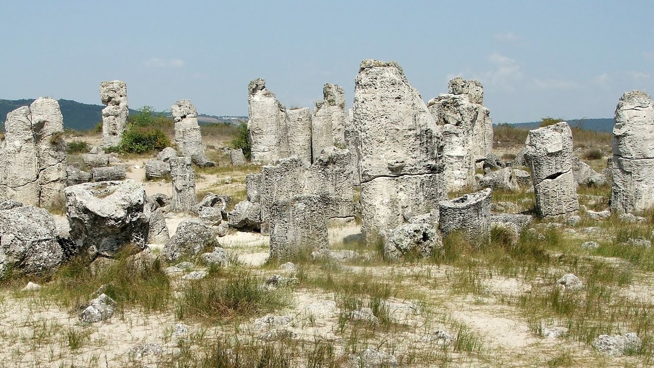
Stone Forest (Stones stuck in the ground, Pobiti Kamani) - Slanchevo 104.78 km away
The Stone Forest of Bulgaria is located 18 km west of Varna, at the foothills of the Eastern Balkan Mountains. Its Bulgarian name, Pobiti Kamani, translates to planted stones, and it is referred to in English as the Stone Desert or Stone Forest.
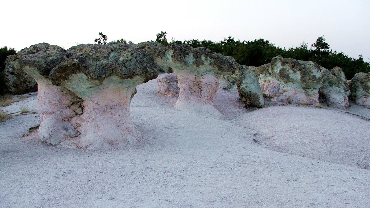
Kamenni Gabi (Stone Mushrooms) - Beli Plast 199.33 km away
The Stone Mushrooms (Kamenni Gabi) nature reserve in Bulgaria is situated east of the village of Beli Plast, along the road that connects Kardzhali to Haskovo. Spanning an area of 3 hectares, the reserve is home to several mushroom-shaped rock formations.

Buzludzha monument - Kazanluk 199.44 km away
Buzludzha is a historically significant mountain located in the Central Balkan Mountains of Bulgaria. At its summit, at an altitude of 1432 meters above sea level, there is an abandoned monument.
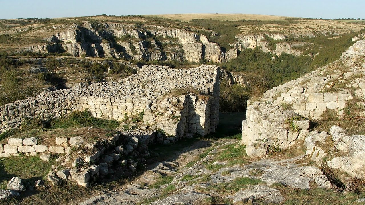
Cherven, a medieval fortified town - Bulgaria 204.58 km away
Located about 30 km south of the city of Ruse in Bulgaria, the Cherven medieval fortress can be found in the Rusenski Lom Nature Park. Originally a Byzantine fortification from the 6th century, it reached the height of its development in the 14th century.
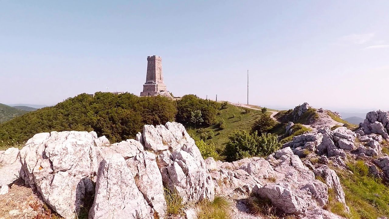
Shipka pass - Shipka 205.53 km away
The Shipka Pass is one of the most spectacular crossings of the Balkan Mountains, and is part of the Bulgarka Nature Park. It separates the provinces of Gabrovo and Stara Zagora, and provides a connection between the cities of Gabrovo and Kazanlak.
Other places
Devetashka cave Devetaki 256.44 km away
The Devetashka Cave is located in Bulgaria, near the village of Devetaki. After the entrance portal, which measures 30 m by 35 m, there is a vast open chamber that is 110 meters wide and 359 meters long.
The Devetashka Cave is located in Bulgaria, near the village of Devetaki. After the entrance portal, which measures 30 m by 35 m, there is a vast open chamber that is 110 meters wide and 359 meters long.
Chudni Mostove (Amazing Bridges) Zabardo 266.68 km away
The Amazing Bridges (Chudni Mostove, Wonderful Bridges) are natural stone bridges. They are located in the Rhodope Mountains, in the Smolyan Province of Bulgaria, within the valley of the Erkyupriya River, at an altitude of 1,450 meters above sea level.
The Amazing Bridges (Chudni Mostove, Wonderful Bridges) are natural stone bridges. They are located in the Rhodope Mountains, in the Smolyan Province of Bulgaria, within the valley of the Erkyupriya River, at an altitude of 1,450 meters above sea level.
Orlovo Oko (Eagle's Eye) Yagodina 290.92 km away
Orlovo Oko (Eagle's Eye) is a lookout viewpoint located in the Rhodope Mountains, near the peak of Saint Ilia and close to the village of Yagodina, Bulgaria. The steel structure, built at an altitude of 1,563 meters, rises 670 meters above the spectacular Buynovsko Gorge, along with the winding river and road that traverse it.
Orlovo Oko (Eagle's Eye) is a lookout viewpoint located in the Rhodope Mountains, near the peak of Saint Ilia and close to the village of Yagodina, Bulgaria. The steel structure, built at an altitude of 1,563 meters, rises 670 meters above the spectacular Buynovsko Gorge, along with the winding river and road that traverse it.
Babsko Praskalo waterfall Tazha 226.24 km away
In the Central Balkans National Park, there are many rivers that cascade down spectacular waterfalls, which the locals call praskalo. One of the smallest waterfalls in the area is Babsko Praskalo, which stands at only 54 meters high.
In the Central Balkans National Park, there are many rivers that cascade down spectacular waterfalls, which the locals call praskalo. One of the smallest waterfalls in the area is Babsko Praskalo, which stands at only 54 meters high.
Saeva Dupka cave Brestnitsa 303.37 km away
The Saeva Dupka Cave is located 2 km south of the village of Brestnitsa. In its five chambers and 400 meters of passageways, you can see the most beautiful cave formations in Bulgaria.
The Saeva Dupka Cave is located 2 km south of the village of Brestnitsa. In its five chambers and 400 meters of passageways, you can see the most beautiful cave formations in Bulgaria.
Planned destinations
Listi bay and wild beach Sinemorets 34.69 km away
The Listi Beach is located between Lipite Beach and Silistar Beach. Historically, pirates had their hideouts along these shores.
The Listi Beach is located between Lipite Beach and Silistar Beach. Historically, pirates had their hideouts along these shores.
Fox Ears Beach (Plazh Lisichi ushi) Sinemorets 35.24 km away
Stone Beach (Kamenniat plazh) Sinemorets 36.2 km away
[ Top ↑ ]
[ Top ↑ ]
Copyright © 2003-2025 Trekkingklub and friends. Reproduction of any text, picture or video from this website, either in printed or electronic form, is prohibited without prior written permission.
The given distances are to be understood as straight line distances, and are approximate. Website made in Miercurea Ciuc  .
.