Campu Cetatii - The Source of the Fairies - Fortress Hill - Alder Lake | Photos


Page no. 1, photos: 1-10, 18 photos in total. >>>

Copyright © 2010 - 2025 Trekkingklub.com.
Already published 8983 photos and 180 videos. Please register for full and ad-free access.
Photos of nearby places


[ Top ↑ ]
Videos of nearby places

Hot air balloon parade 2015 - Campu Cetatii 2.53 km away
This year, the Hot Air Balloon Parade was organized in Campu Cetatii for the tenth time. Unfortunately, the weather only allowed for flying on Saturday morning and evening.
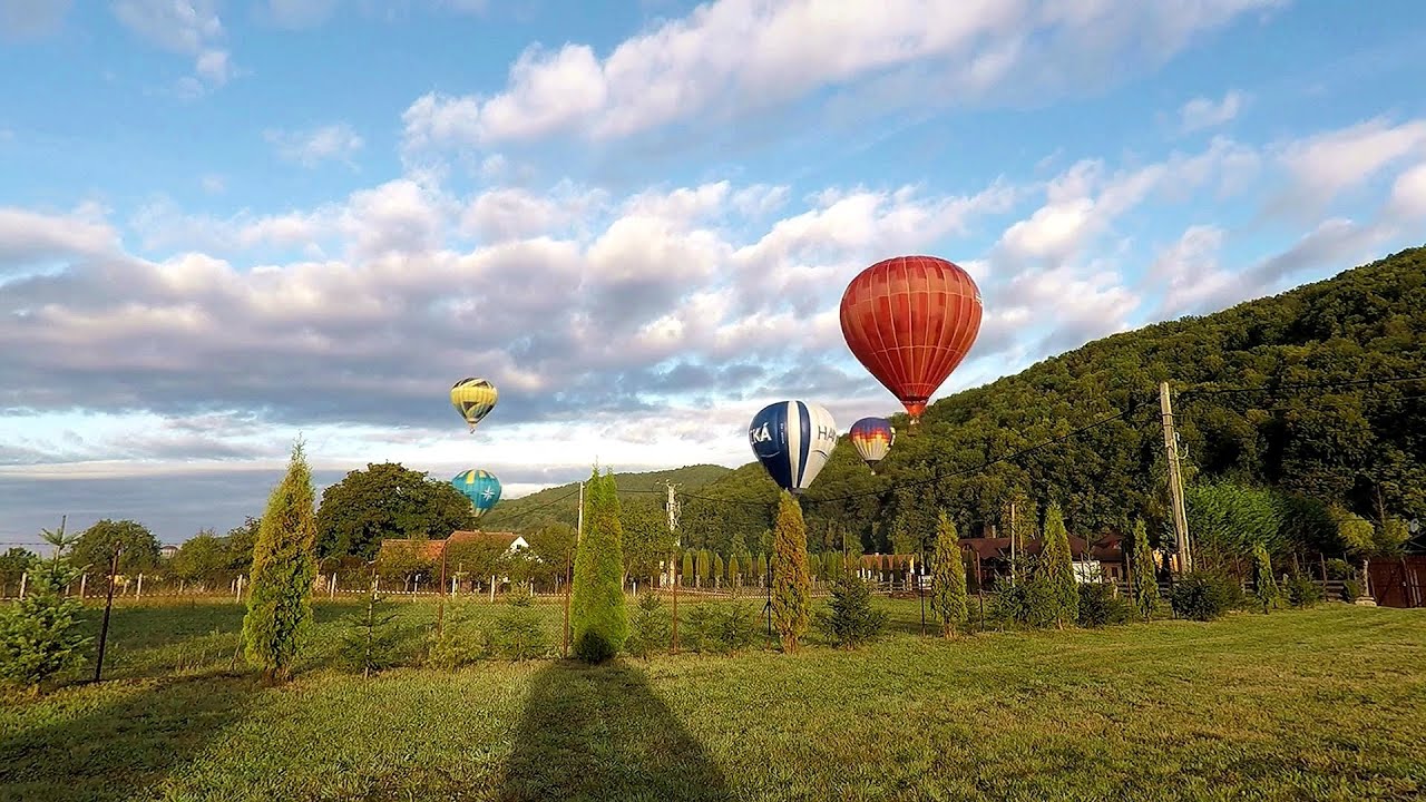
Hot Air Balloon Parade 2018 - Campu Cetatii 2.53 km away
This year, the hot air balloons flew low over Campu Cetatii. The weather did not really favor the parade.

The Heart of Jesus look-out - Lupeni 36.01 km away
Through the mud on Gordon Mountain, above Farkaslaka (Lupeni commune, Harghita county, Transilvania), on a cloudy afternoon, at the end of February. The destination is the Heart of Jesus lookout, nicknamed as Pléhkrisztus (The Tin Christ).

Pricske peak - Giurgeu Mountains 46.02 km away
If we want to reach Pricske (Prisca) peak, which rises above Gheorgheni and Lazarea, we start from the valley of the Güdüc (Ghidut) stream. Our path leads us past the ruins of a building known as the White House.

With snowshoes in the Tihu creek valley - Rastolita 46.74 km away
We met geotrekking treasure hunters from Gheorgheni, Miercurea Ciuc and Targu Mures in Rastolita. We entered the Calimani Mountains with an off-road vehicle, along the Rastolita and Tihu streams.
Other places
Roman Baths (Baile Romane) Cetea, Trascau Mountains 122.93 km away
Among the valleys of the Trascau Mountains, the Cetea Gorge best deserves the name of a crevice valley. Here, the waters of the Cetea Stream cut through the Mariuta limestone cliff, flowing through a narrow crevice that is only about 1-2 meters wide.
Among the valleys of the Trascau Mountains, the Cetea Gorge best deserves the name of a crevice valley. Here, the waters of the Cetea Stream cut through the Mariuta limestone cliff, flowing through a narrow crevice that is only about 1-2 meters wide.
Sugau Rock lookout point and iron path (B/C) 64.22 km away
Sugau Rock lookout point and iron path (B/C). Sugau Gorges - Munticelu Nature Reserve, Hasmas Mountains.
Sugau Rock lookout point and iron path (B/C). Sugau Gorges - Munticelu Nature Reserve, Hasmas Mountains.
Waterfalls of Velnita stone-quarry Targu Ocna 128.11 km away
Starting from the Velnita quarry, an adventurous nature enthusiast, accustomed to wild and rugged terrains, will discover a true waterfall paradise. At the upper part of the quarry, two streams converge.
Starting from the Velnita quarry, an adventurous nature enthusiast, accustomed to wild and rugged terrains, will discover a true waterfall paradise. At the upper part of the quarry, two streams converge.
Mill of the Devils (Moara Dracilor) Tasna Gorge (Cheile Tasnei) 272.78 km away
The Tasna Gorges are located in the Mehedinti Mountains, approximately 15 km from the resort of Baile Herculane. The gorges are part of the Domogled - Cerna Valley (Valea Cernei) National Park.
The Tasna Gorges are located in the Mehedinti Mountains, approximately 15 km from the resort of Baile Herculane. The gorges are part of the Domogled - Cerna Valley (Valea Cernei) National Park.
Astragalus iron path in winter Glod Stone, Munticelu 64.5 km away
The official website of the Sugau Gorge published information about a new via ferrata climbing route named Astragalus. Sugau Gorges - Munticelu is a nature conservation area part of Natura 2000 located in Neamt County, which borders Harghita County.
The official website of the Sugau Gorge published information about a new via ferrata climbing route named Astragalus. Sugau Gorges - Munticelu is a nature conservation area part of Natura 2000 located in Neamt County, which borders Harghita County.
[ Top ↑ ]
[ Top ↑ ]
Select language: - Magyar - Romana - Deutsch - Français - Italiano - Español - Copyright © 2003-2025 Trekkingklub and friends. Reproduction of any text, picture or video from this website, either in printed or electronic form, is prohibited without prior written permission. The given distances are to be understood as straight line distances, and are approximate. Website made in Miercurea Ciuc