Meresti cave - Varghis Gorges - photos

65046734350
65047444351
65047524352
65047534353
65047584354
65047634355
65047664356
65047684357
Page no. 1, photos: 1-8, 18 photos in total. >>>

[ Hu ] - [ Ro ] - Caving - Varghis Gorges
2nd July 2004. Copyright © 2004 - 2024 Trekkingklub.com.
Already published 8093 photos and 66 videos. Please register for full access.

Photos of nearby places

Varghis Gorges in winter
Varghis Gorges in winter (23rd February 2008 - 12 photos) 0.11 km away
A cave from Varghis Gorges
A cave from Varghis Gorges (23rd May 2004 - 12 photos) 0.14 km away
Caves no. 57 and 58 from Varghis Gorges
Caves no. 57 and 58 from Varghis Gorges (24th February 2008 - 15 photos) 0.21 km away
Wolf trail: Stone Barn - Wonder Stone - Stone Field - Mal Peak
Wolf trail: Stone Barn - Wonder Stone - Stone Field - Mal Peak (23rd February 2008 - 24 photos) 0.23 km away
Varghis Gorges
Varghis Gorges (1st May 2004 - 15 photos) 0.3 km away
In memoriam Dénes István - Godra karst area
In memoriam Dénes István - Godra karst area (7th September 2006 - 10 photos) 4.73 km away
Chirui Bath
Chirui Bath (1st April 2004 - 6 photos) 9.95 km away
[ Top ↑ ]

Videos of nearby places
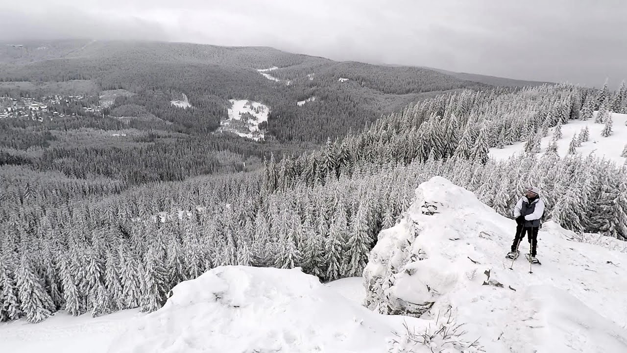
Nobody's lake - Miercurea Ciuc 22.4 km away
The passage of time (time lapse), dusk at Nobody's Lake. Miercurea Ciuc and the Sumuleu mountain can be seen in the background.
Iron path - Harghita-Madaras 26.52 km away
Amateur filming in Harghita-Madaras, holding the camera by hand in the car, and helmet-mounted on the via ferrata. I climbed an iron path for the first time in my life on the Nyerges cliffs (Stancile Seii), I didn't have the right equipment yet. That's where I fell in love with climbing.
Walking to the top of Sumuleul Mare - Sumuleu Ciuc 28.34 km away
This was my first attempt at shooting a video.
The Heart of Jesus look-out - Lupeni 29.49 km away
Through the mud on Gordon Mountain, above Farkaslaka (Lupeni commune, Harghita county, Transilvania), on a cloudy afternoon, at the end of February. The destination is the Heart of Jesus lookout, nicknamed as Pléhkrisztus (The Tin Christ).
Preacher's Rock - Bodoc Mountains 35.06 km away
In the Bodoc Mountains, west-southwest from the Henter peak, we find a rock formation shaped like a mushroom by erosion, called Preacher's Rock. This 2-meter high rock probably got its name from the pagan Hungarian priests, who preached here in the past.

Other videos

Hias Klettersteig Silberkarklamm, Ramsau am Dachstein 909.12 km away
The Hias Klettersteig in the Silberkarklamm gorge is the first of the three via ferrata routes, and perhaps the easiest to complete. Two cable bridges and a few trickier sections make it interesting, but it is truly impressive due to the view of the narrow gorge.
Giant fir trees Ghimes 57.27 km away
One of the lesser-known attractions of Ghimes is the two giant-sized common fir trees. They are 42 meters tall, and have diameters of 110 cm and 130 cm at chest height. Their estimated age is 200-250 years.
Seven Ladder Canyon and Waterfall Piatra Mare Mountain 72.86 km away
The Seven Ladder Gorge is the largest and most spectacular gorge in the Piatra Mare massif. The narrow canyon has a length of 160 meters, and over a drop of 58 meters includes 7 bigger and several smaller waterfalls. The gorge can be explored on metal stairs and platforms.
Stan Valley Canyon 119.4 km away
The Stan Valley is located near Lake Vidraru, southwest of it, in the Fruntii Mountains. Those who have visited the Seven Ladders Waterfall will appreciate this canyon, outfitted with infrastructure for tourist accessibility.
Snow-covered valley of Balea and the Transfagarasan in winter The descent 99.06 km away
[De] Die Transfogarascher Hochstraße und das Balea-Tal im Winter. Siebenbürgen, Rumänien.
Les Gorges de la Méouge France 1557.06 km away
Following today's climb, I experienced the soothing pleasure of immersing myself in the turquoise waters of the Méouge creek, in the pond beneath a waterfall. If you find yourself in Sisteron or Grenoble, do not miss the opportunity to explore the magnificent Méouge valley near Ribiers. And do not leave your swimwear behind.
Mürren-Gimmelwald Klettersteig Switzerland 1351.34 km away
The Mürren-Gimmelwald Klettersteig is a relatively new via ferrata route in Switzerland, located in the Lauterbrunnen Valley. It is moderately difficult, but incredibly scenic. Unusually, you don't climb upwards here, but rather descend.
Mammuthöhle Dachstein Salzkammergut, Austria 910.49 km away
The first station of the Dachstein Krippenstein cable car, which starts in Obertraun, in the southern part of Lake Hallstatt, is Schönbergalm. Here you can find the Ice Cave and the Mammoth Cave. The latter is not named after the now extinct relatives of elephants, but rather because of its enormous size.
Ski resort Poiana Brasov Postavarul Mountains 71.9 km away
Shining sun and an Austria-feeling on the impeccable slopes of the ski paradise Poiana Brasov above Brasov. Sunbathing, coffee and refreshing drinks on the terrace of Julius Römer chalet.
Crivadia Gorges 199.54 km away
The Crivadia Gorge is located next to the village of Crivadia, which belongs to Banita. Access is difficult, and the hike is made through the streambed, with water up to the waist at its narrowest point.
Rosina Klettersteig Silberkarklamm, Ramsau am Dachstein 909.17 km away
The Rosina Klettersteig is the most difficult via ferrata in the Silberkar gorge, has a D difficulty rating, and it is a vertical masterpiece. After a short suspension bridge above the stream, it leads up the rock wall next to the gorge waterfall, all the way vertically.
Echernwand Klettersteig Hallstatt, Austria 915.71 km away
I climbed the via ferrata on the Echernwand rock wall at dusk. This route is located above one of Austria's most beautiful lakes, and above Hallstatt. The iron climbing route was quite challenging at times, with the most exciting section being the Roll-dachl, an exposed rock formation, shaped like a nose.
Preacher's Rock Bodoc Mountains 35.06 km away
In the Bodoc Mountains, west-southwest from the Henter peak, we find a rock formation shaped like a mushroom by erosion, called Preacher's Rock. This 2-meter high rock probably got its name from the pagan Hungarian priests, who preached here in the past.
Castle panorama route, Zoltán Tálos memorial route, Besieger's route Csesznek 596.88 km away
Castle panorama route (D), Zoltán Tálos memorial route (E), Besieger's route (C), Kőmosó-ravine, Csesznek, Veszprém county, Hungary. The via ferratas in Csesznek are suitable for both getting acquainted with climbing, and assessing our capabilities.
5fingers, WeltNATURerbeblick, Welterbespirale, Dachstein-Hai Dachstein-Krippenstein 911.66 km away
The second station of the cable car departing from Obertraun is the Krippenstein peak (2100 m). Here you can find the famous 5fingers lookout, which offers a unique view of Hallstatt and Obertraun below, as well as the Hallstättersee lake.
[ Top ↑ ]
[ Top ↑ ]
Copyright © 2003-2024 Trekkingklub and friends. Reproduction of any text, picture or video from this website, either in printed or electronic form, is prohibited without prior written permission. Nearby settlements: Meresti 6.69 km away, Tourist attractions Meresti 6.69 km away. The given distances are to be understood as straight line distances, and are approximate. Website made with love Made with love in Miercurea Ciuc.