Tourist attractions near Augustin (Augustin, Brasov county, Romania)
Photos of nearby places

Cavities in Tipia of Ormenis - Persani Mountains (24 photos) 7 km away. Cavities in Tipia of Ormenis - Persani Mountains (Muntii Persani).

Thieves Cave - Persani Mountains (20 photos) 8.8 km away. The Thieves' Cave at Apata is located in the valley of the Tepeu creek, renowned for its outcrop of red clayey limestone, which is very rich in ammonites. A tributary of the stream is formed by the waters of a spring fed by the watercourse coming from the cave's gallery.

Shells Cave - Persani Mountains (33 photos) 28.7 km away. Shells Cave (Pestera Scoicilor) - Persani Mountains (Muntii Persani).


Veczer Rock (12 photos) 34.4 km away. The Veczer Rock is located 3 km south of the village of Ariusd, on the southern slope of the place named Veczer. The tall hill is encircled by the Olt River, with conglomerate rocks resembling giants stretching above the river.

Ruins of the Harom fortress - Jigodin Bath (10 photos) 35 km away. The Harom Fortress was built around the beginning of the 12th century and was part of the system of fortifications that protected Transylvania from the east. It is located south of Miercurea Ciuc, east of Harom Peak, which has an altitude of 1079 m, near the southwestern limits of Jigodin Bath (Baile Jigodin).


Harghita Bath - Harghita Mountains (15 photos) 38.1 km away. Harghita Bath (Harghita-Bai) - Harghita Mountains.

Rák lake - Porumbenii Mari (15 photos) 42.1 km away. The Rak lake is located 2 km north of the village Porumbenii Mari, at 600 m altitude. The circumference of the lake is 800 m, the length 250 m, width 150 m, maximum depth 7 m, and the surface is 28000 m2 (10 ha together with the joined area).


The Rock with a Hole - Corund (6 photos) 52.1 km away. The Likas Stone (The Rock with a Hole) is located near Corund, on a meadow next to the road and four graves. In the middle of the conglomerate rock block, there is a perfectly drilled, heart-shaped hole.

Seven Ladder Waterfall - Piatra Mare Mountains (12 photos) 53.7 km away. The Seven Ladders are located in the middle-western part of the Piatra Mare Mountains, at an average altitude of 980 m, not far away from Valea Timisului (Dambu Morii), on the Seven Ladders River, the left-side affluent of Sipoaia creek. These are the greatest and the most spectacular gorges of the whole Piatra Mare Mountains.

Piatra Mare peak and surroundings (24 photos) 55.4 km away. Piatra Mare hut - Piatra Mare peak - Stone Mushrooms - Stone Barn.

The sources of the river Trotus - Fagetel (10 photos) 56 km away. Fagetel, Piposz property, The sources of the river Trotus (Tatros).

Surroundings of Covasna town (24 photos) 57.1 km away. Fortress of Fairies, Narrow gauge railway Covasna-Comandau

Tower of King Rock - Piatra Craiului Mountains (15 photos) 59.2 km away. Border Ravine Valley (Padina Hotarului), Turm des Königstein (Turnul Pietrei Craiului).

Little King Rock - Piatra Craiului Mountains (14 photos) 59.4 km away. Little King Rock (Piatra Mica) - Piatra Craiului Mountains (King Rock).

The Cats Gorge - Curmatura Cabin (20 photos) 59.8 km away. The Cat's Gorge - Valley of the Gorge Stream - Curmatura Cabin - Rift Saddle.
[ Top ↑ ]
Videos of nearby places
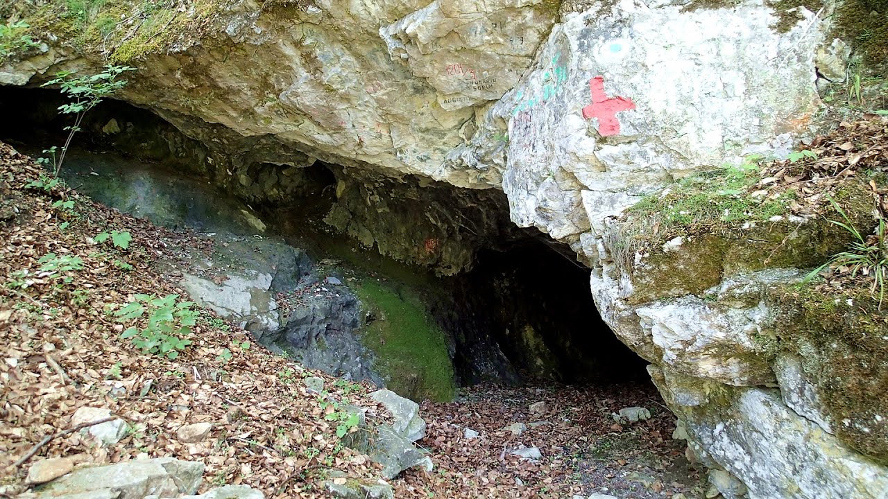
The Cave of Thieves - Apata 8.8 km away. The Cave of Thieves (Pestera Hotilor, Tolvajos), located in the Olt Gorge at Racos, is situated at the source of the Tepeu creek. From the karst spring that emerges from the cave, one of the branches of the creek originates.
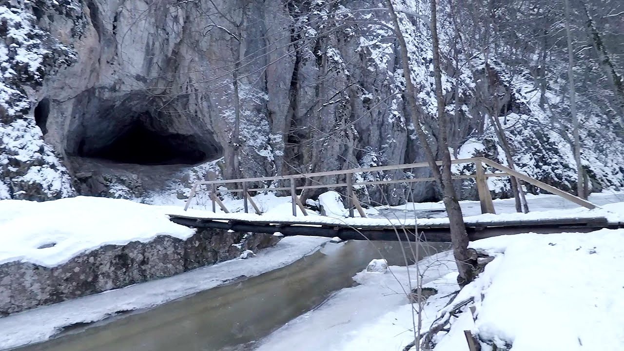
Varghis gorges in winter 19.2 km away. I went out to admire the ice stalagmites (standing icicles) in the Varghis Gorge. Anyone arriving here at the end of winter can observe meter-high ice stalagmites in the entrance area of Meresti Cave (now known as Orban Balazs Cave).

Preachers Rock - Bodoc Mountains 26.5 km away. In the Bodoc Mountains, west-southwest from the Henter peak, we find a rock formation shaped like a mushroom by erosion, called Preacher's Rock. This 2-meter high rock probably got its name from the pagan Hungarian priests, who preached here in the past.

Saint Anne lake - Ciomat-Puturosu 27.3 km away. Lake Saint Anna is the only well-preserved volcanic crater lake in Eastern Europe. Here are some images from an afternoon outing.

Nobodys lake - Miercurea Ciuc 37.7 km away. The passage of time (time lapse), dusk at Nobody's Lake. Miercurea Ciuc and the Sumuleu mountain can be seen in the background.
Other places
Abandoned copper mine Tsar Asen, Pazardzhik 421.4 km away. The turquoise waters of this mine lake are extremely beautiful but dangerously poisonous. Do not descend to the shore or touch the water!
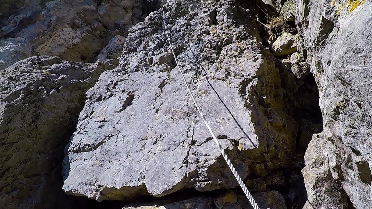
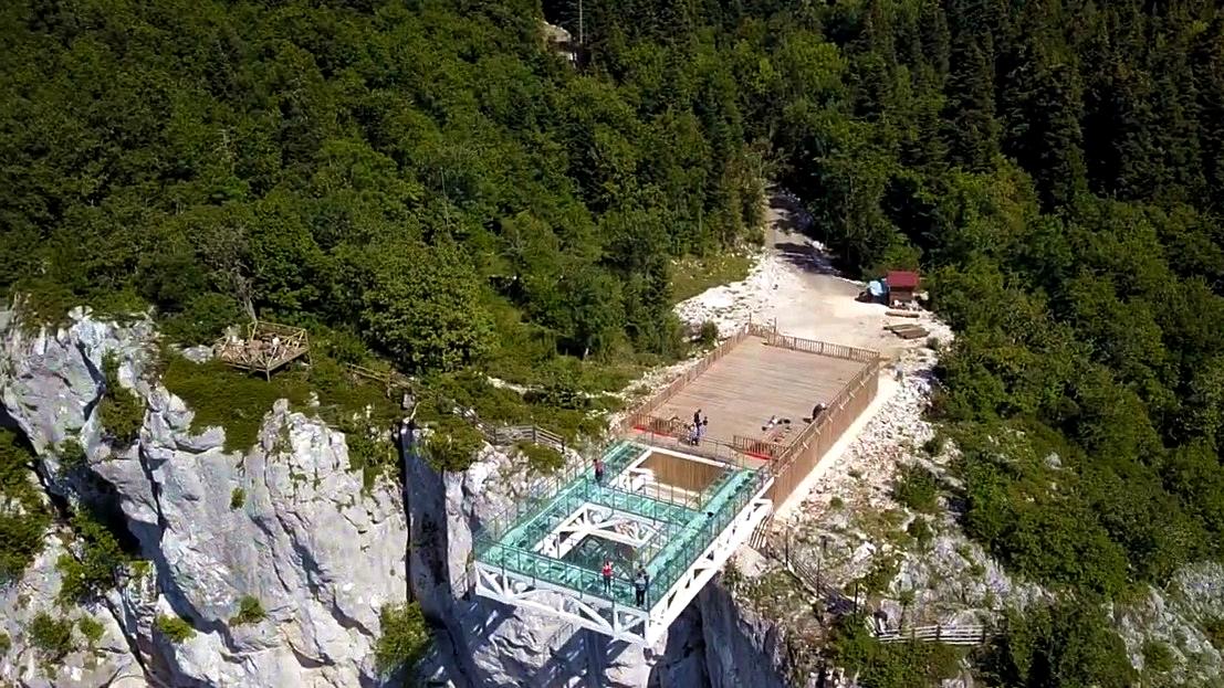
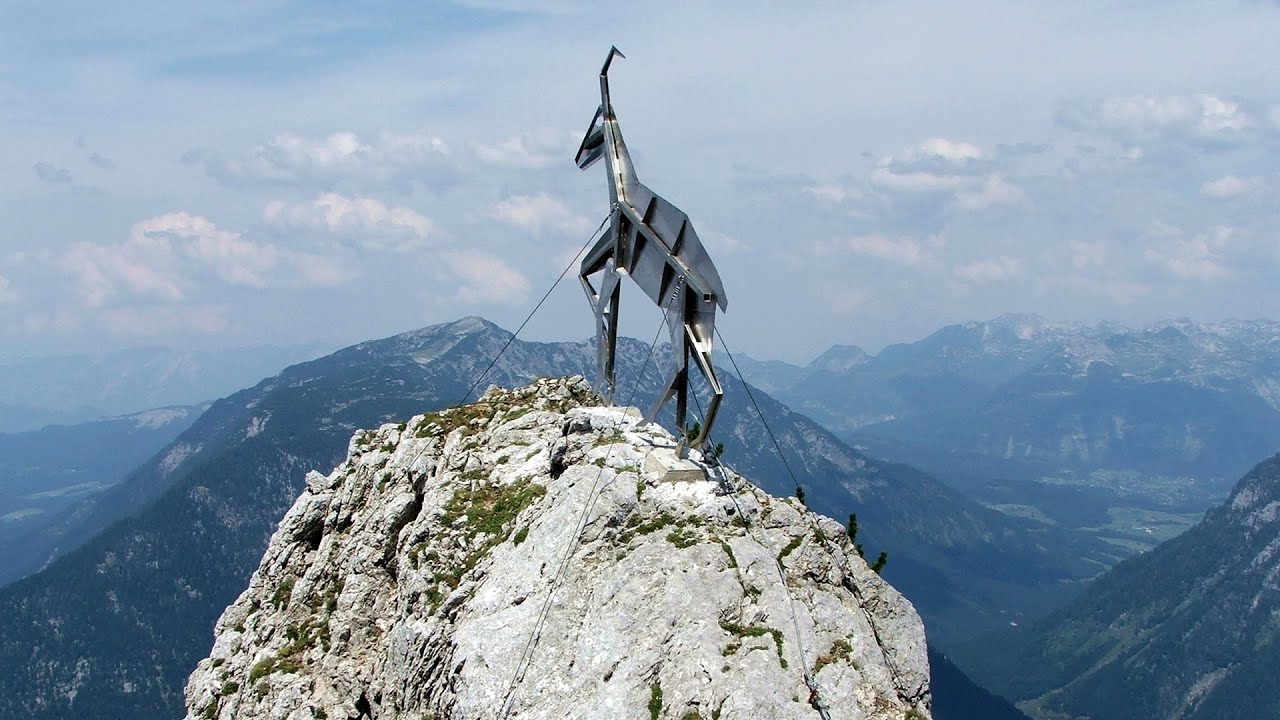
Rossloch Klettersteig Leopoldsteiner See The D/E difficulty Rossloch via ferrata is situated at the top of the 900-meter-high Seemauer cliff, overlooking the Leopoldsteiner See in the western part of the Hochschwab mountain range. It is designed for experienced via ferrata climbers, and complements the already impressive Emperor Franz Joseph via ferrata, as the two routes can be connected.
Falco Peregrinus 2 via ferrata Falcons Rock, Corbu 108.9 km away. Falco Peregrinus (Peregrine falcon) 2 via ferrata (D) - Falcon's Rock, Corbu.
The Bears Jump iron path Baia de Fier 169.1 km away. The Bear's Jump (Saritoarea Ursului) is a fantasy-named via ferrata that opened in May 2018 near Baia de Fier, alongside the Middle Belt (Spirala Medie). Both routes begin from the G zone of the rock face that conceals the Women's Cave (Pestera Muierilor).

Stan Valley Canyon 105.3 km away. The Stan Valley is located near Lake Vidraru, southwest of it, in the Fruntii Mountains. Those who have visited the Seven Ladders Waterfall will appreciate this canyon, outfitted with infrastructure for tourist accessibility.

Sheepdogs Govora sheepfold Retezat mountains 212 km away. On the second day of my weekend Retezat hike, I visited a sheepfold on the Lancita Ridge. To my great disappointment, they didn't make cheese or curd here.
Gornjak via ferrata and Kudelinovs fortress Zdrelo 372.1 km away. Difficulty level C/D, total length: 400 m, height difference: 330 m, year of construction: 2019, total length of the route to Kudelinov's fortress: 1100 m. Access to the via ferrata is free.
Via ferrata Dachstein Gams Krippenstein, Obertraun am Hallstättersee The Dachstein Gams is a new via ferrata route on Krippenstein. It has three parts: Himmeleck (A/B), Gams (C), and Nordwand (E).
[ Top ↑ ]
Copyright © 2003-2026 Trekkingklub and friends. Reproduction of any text, picture or video from this website, either in printed or electronic form, is prohibited without prior written permission. Website made with love  in Miercurea Ciuc.