Tourist attractions near Prelucele (Negreni, Cluj county, Romania)
Photos of nearby places

Oxen Waterfall - Padurea Craiului Mountains (12 photos) 16 km away. Oxen Waterfall (Cascada Boilor) - Padurea Craiului Mountains.


Napistileu cave - Padurea Craiului (10 photos) 20.8 km away. Napistileu (Ungurul Mic) cave - Padurea Craiului Mountains.

Cave of Winds - Padurea Craiului Mountains (24 photos) 20.8 km away. The Cave of Winds (Pestera Vantului) is located in the Padurea Craiului Mountains, not far from Frantura meadow, near Suncuius, on the left geographical side of the Crisul Repede River. The Cave of Winds was discovered in 1957 by Béla Bagaméri and is currently (as of 2003) the longest cave system known in Romania as well as in the Carpathian Basin.

The cave from the spring - Padurea Craiului Mountains (8 photos) 20.9 km away. Pestera de la Izvor (The cave from the spring) - Padurea Craiului Mountains.

Moanei Cave - Padurea Craiului Mountains (58 photos) 22.8 km away. The Moanei Cave (Pestera Moanei) is located on the upper course of the Misid River, on the right side of the Misid Gorge (Cheilor Misidului). The cave has two entrances, one fossil and sloped, while a subterranean stream flows through the active gallery.

Valley of Hell - Padurea Craiului Mountains (23 photos) 23.5 km away. Valley of Hell (Valea Iadului) - Padurea Craiului Mountains.

Fern Cave - Padurea Craiului Mountains (9 photos) 27.3 km away. Ferigi (Fern) Cave - Padurea Craiului Mountains.

Sohodol pit cave - Padurea Craiului Mountains (10 photos) 29.4 km away. Sohodol pit cave (Avenul Sohodol) - Padurea Craiului Mountains.

Kings Cave - Padurea Craiului Mountains (48 photos) 30 km away. Craiului (Kings) Cave - Padurea Craiului Mountains.


Dragons Garden - Galgau Almasului (20 photos) 45.9 km away. The natural reservation site Dragon's Garden (Gradina Zmeilor, Sárkányok kertje) from Galgaul Almasului is located in Salaj County, in the Western Carpathians. This natural playground is made up of interesting and unusual sandstone formations, an ensemble of 10-12 m high towers with strange figures cut in sandstone by the wind and water erosion.


Spherical concretions from Feleac (18 photos) 64.1 km away. The spherical concretions from Feleac are sedimentary rock materials that were cemented together to form a hard structure. The surrounding sediments slowly erode away, exposing the concretion.

Tureni Gorge iron path visiting route (24 photos) 77.8 km away. Tureni Gorge iron path visiting route (via ferrata) - Trascau Mountains.


Turda Gorge - Trascau Mountains (9 photos) 78.2 km away. Turda Gorge (Cheile Turzii) - Trascau Mountains.

Turda Gorge - Trascau Mountains (11 photos) 78.2 km away. Turda Gorge (Cheile Turzii) - Trascau Mountains.
[ Top ↑ ]
Videos of nearby places

Hodoaba Valley iron path - Suncuius 20.6 km away. The Hodoaba Valley iron path is Romania's shortest and easiest (official) via ferrata route. It is located near Suncuius, in the Padurea Craiului Mountains, on the left bank of the Crisul Repede River.


Acapulcos spur via ferrata 20.6 km away. Acapulco's spur (Pintenul lui Acapulco) via ferrata (B/C) - Montana Land, Suncuius.

Fairy Cliff via ferrata route - Vadu Crisului 23 km away. Fairy Cliff (Peretele Zanelor) via ferrata route - Vadu Crisului. In Vadu Crisului, in the Padurea Craiului Mountains, on the right bank of the Crisul Repede, you can find the newest, in chronological order (2015) the fifth Transylvanian, new type of via ferrata route.

Via Ferrata Fairy Castle - Vadu Crisului 23.1 km away. Via Ferrata Fairy Castle (Castelul Zanelor, Casa Zmeului, The House of the Dragon) - Vadu Crisului. South of Vadu Crisului, in the Padurea Craiului Mountains, lies the Vadu Crisului Gorge, a section of the Crisul Repede river that narrows between rocky walls.
Other places
Roman bridge Nenkovo Along the Borovitsa River, near the village of Nenkovo, there is a Roman Bridge. It connects the two banks of the Borovitsa River.
Iskar gorge Lyutibrod Temnata dupka cave Lakatnik 432.1 km away. The Iskar is the longest purely Bulgarian river, the oldest river in the Balkans, and a right tributary of the Danube. The river is 368 km long, with approximately 150 km consisting of a gorge.
Óbányai Valley Eastern Mecsek 348.6 km away. The Óbányai Valley is located in the Eastern Mecsek Landscape Protection Area, stretching between Óbánya and Kisújbánya. Its attractions include the Slanting waterfall or Fairy Stairs, and the Dripping Rock.
Sleeping Beauty cave Shpella e Radacit (Sleeping Beauty) cave.


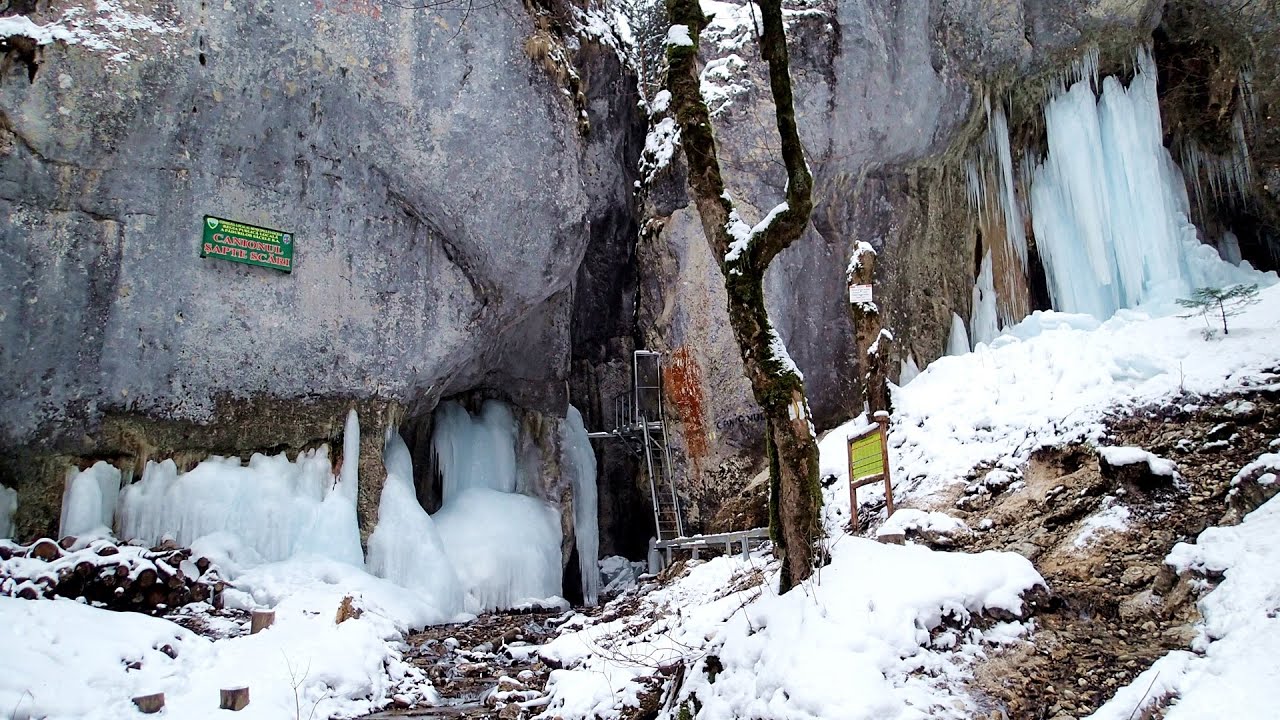
Seven Ladder Canyon in Winter Piatra Mare Mountain 266.3 km away. Seven Ladder Canyon and Waterfall in Winter - Piatra Mare Mountain
[ Top ↑ ]
Copyright © 2003-2026 Trekkingklub and friends. Reproduction of any text, picture or video from this website, either in printed or electronic form, is prohibited without prior written permission. Website made with love  in Miercurea Ciuc.