Billy-goat lake, Closed Gates - Retezat Mountains - video

Billy-goat lake, Closed Gates - Retezat Mountains - videoPlay
The most unique ridge trail of the Retezat Mountains is the Closed Gates.

Below, at an altitude of 2070 m above sea level, is the Billy-goat lake. Its area is 2.3 ha, with a maximum depth of 6 m. It can be recognized by the small green island in the southwestern part, which rises 1 meter above the water.

On the way, we disturbed a bear cub, saw some goats, and we even met shepherd dogs. It was a pleasant surprise to see the rhododendron still blooming. At the edge of the lake, a two-faced (pseudo) saint meditated.
[ Hu ] - [ Ro ] - Hiking - Retezat Mountains
11th July 2015. Filmed with SJCAM SJ5000 Plus. Copyright © 2015 - 2024 Geo Trekker Videos. Music: Please wake up by Meydan.
Already published 8077 photos and 65 videos. Please register for full access.

Photos of nearby places

Zeicu cave - Retezat Mountains
Zeicu cave - Retezat Mountains (9th June 2007 - 47 photos) 10.71 km away
Cave no. 4 from Scorota Gorges - Retezat Mountains
Cave no. 4 from Scorota Gorges - Retezat Mountains (8th June 2007 - 16 photos) 11.28 km away
Pit no. 5 from Scocul Mare gorge
Pit no. 5 from Scocul Mare gorge (8th June 2007 - 17 photos) 11.39 km away
Campusel forester's lodge - Retezat Mountains
Campusel forester's lodge - Retezat Mountains (6th June 2007 - 5 photos) 13.24 km away
Sura Mare cave - Sureanu Mountains
Sura Mare cave - Sureanu Mountains (25th September 2008 - 60 photos) 24.38 km away
Natural bridge next to the Banita Stone Quarry
Natural bridge next to the Banita Stone Quarry (13th September 2015 - 12 photos) 27.56 km away
Although the Banita Stone Bridge is not far from the road that passes through the village, it is located beyond the railway line, so its approach is a bit cumbersome. We can go around the railway line on Carierei Street, and then we have to walk a few meters from the stone quarry.
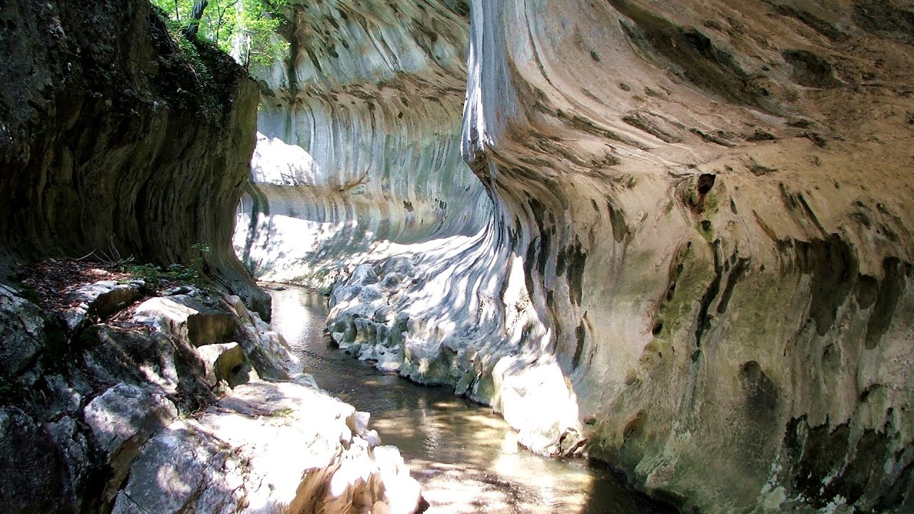
Ponorici-Cioclovina cu Apa cave - Sureanu Mountains
Ponorici-Cioclovina cu Apa cave - Sureanu Mountains (24th September 2008 - 29 photos) 27.8 km away
[ Top ↑ ]

Videos of nearby places

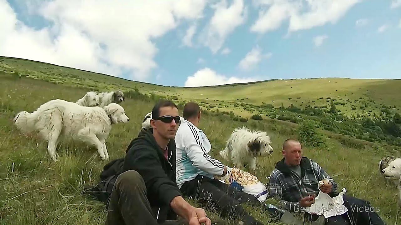
Sheepdogs - Govora sheepfold - Retezat mountains 5.32 km away
On the second day of my weekend Retezat hike, I visited a sheepfold on the Lancita Ridge. To my great disappointment, they didn't make cheese or curd here.
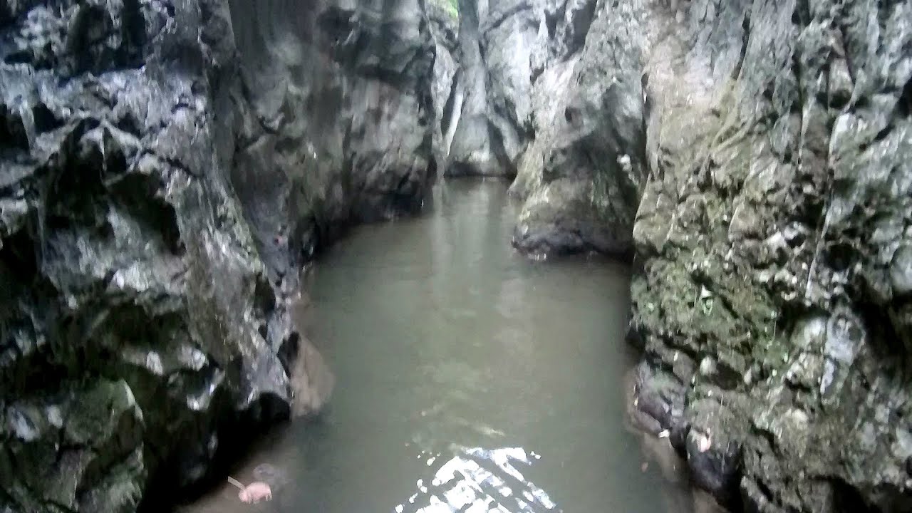
 The owners sell the more special types of sheep and rams in the autumn.
Crivadia Gorges 24.21 km away
The Crivadia Gorge is located next to the village of Crivadia, which belongs to Banita. Access is difficult, and the hike is made through the streambed, with water up to the waist at its narrowest point.
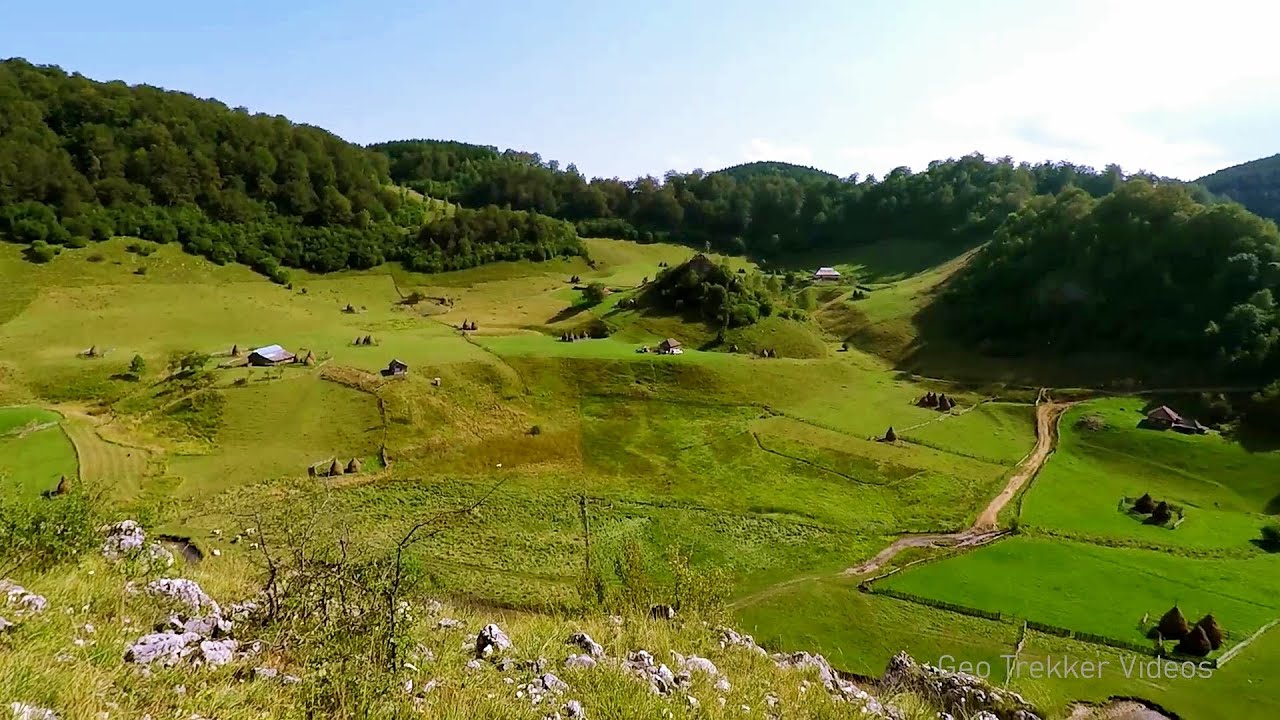
Banita Gorges and Banita rock bridge 31.35 km away
They say about this place that only very few people know about it, but that's not true. In fact, most nature lovers have heard of it, seen pictures taken here, even if not everyone has been able to come here. Since it has been talked about everywhere, and it has been advertised, I have also been planning to come here for years.
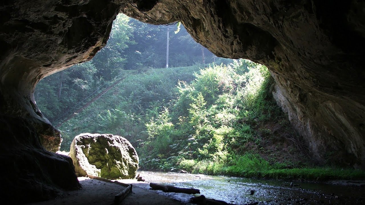
Bolii Cave - Banita 32 km away
The Bolii Cave is located 6 km north of Petrosani, on the road that connects Hateg with the Jiu Valley. Here, the railway line that connects the two parts of Hunedoara County passes through, featuring a total of 66 curves and 8 tunnels.
Corcoaia Gorges - Gorj county 32.44 km away
The Corcoaia Gorge is one of the most beautiful tourist attractions in the Cerna Valley. It can be reached by car, 43 km away from Baile Herculane, of which about 17 km is on a dusty gravel road. The spectacular part of the gorge is relatively short, about 300 m.

Other videos

Via Ferrata Centenario C.A.O Monte Grona Italia 1065.93 km away
In the magnificent rocky world of Monte Grona, the Centenario via ferrata leads upwards, which I had the opportunity to climb accompanied by lizards.
Wild Ferenc iron path Suhardul Mic 272.01 km away
While I climbed the new iron path mostly in the dark for the first time, this time I managed to explore it during the day. But I still missed the sunset by a few minutes.
Schulter Anstieg klettersteig Hoher Dachstein, Austria 750.51 km away
Two iron paths lead to the top of the Hoher Dachstein. The Randkluft is shorter, but can only be reached through a glacier with cracks. It is dangerous to reach the starting point, that's probably why it was closed now.
Crystal Cave at Farcu Mine 164.87 km away
In the Padurea Craiului Mountains, near Rosia, in the Farcu bauxite mine, in 1987, the miners accidentally discovered a cave. It was filled with crystal-shaped limestone formations.
Gelmerbahn Guttannen, Schweiz 1135.68 km away
The Gelmerbahn in Switzerland is the steepest open funicular in Europe. It transports tourists from an altitude of 1412 meters to over 1860 meters above sea level, as well as to the Gelmer lake located at 1849 meters.
L'Escale á Peille iron path Alpes-Maritimes, France 1239.31 km away
One of the challenging via ferratas in the Maritime Alps is the L'Escale a Peille. One of its elements is a steel cobweb, where you can feel like you're hanging in the air.
Meziad cave Padurea Craiului Mountains 158.02 km away
The Meziad Cave is located near the village of Meziad, 22 km north of Beius, in the Padurea Craiului Mountains. It is one of our first tourist caves, its exploration is associated with the name of Gyula Czárán, cave researcher and writer.
Hot air balloon parade 2015 Campu Cetatii 215.45 km away
This year, the Hot Air Balloon Parade was organized in Campu Cetatii for the tenth time. Unfortunately, the weather only allowed for flying on Saturday morning and evening.
Via ferrata du Diable France 1263.99 km away
The Devil's Iron Path (Via ferrata du Diable) is a multi-part via ferrata, located above a spectacular waterfall (Cascade du Nant), in a gorge, below the Victor-Emmanuel fort. For me, this climbing route presented the greatest challenge so far.
Iron path Harghita-Madaras 236.95 km away
Amateur filming in Harghita-Madaras, holding the camera by hand in the car, and helmet-mounted on the via ferrata. I climbed an iron path for the first time in my life on the Nyerges cliffs (Stancile Seii), I didn't have the right equipment yet. That's where I fell in love with climbing.
Rudariei watermills Eftimie Murgu 85.78 km away
I have visited the twenty-two wooden water mills with horizontal wheels, located in the valley of the Rudaria stream, mostly in the rain and under an umbrella. Some of them are still in use today. In 1874, there were still fifty such water mills operating in the village.
The Heart of Jesus look-out Lupeni 213.07 km away
Through the mud on Gordon Mountain, above Farkaslaka (Lupeni commune, Harghita county, Transilvania), on a cloudy afternoon, at the end of February. The destination is the Heart of Jesus lookout, nicknamed as Pléhkrisztus (The Tin Christ).
Via ferrata de la Grande Fistoire France 1330.1 km away
Because I lost the footage I made the first time (don't buy SD cards from Alibaba!), at the end of June I visited this great and exciting via ferrata again. It has a 59-meter long suspension bridge (one of the longest in the Alps), at 200 m height, and a 32-meter long, uncomfortably swinging Nepalese bridge.
Preacher's Rock Bodoc Mountains 241.35 km away
In the Bodoc Mountains, west-southwest from the Henter peak, we find a rock formation shaped like a mushroom by erosion, called Preacher's Rock. This 2-meter high rock probably got its name from the pagan Hungarian priests, who preached here in the past.
[ Top ↑ ]
[ Top ↑ ]
Copyright © 2003-2024 Trekkingklub and friends. Reproduction of any text, picture or video from this website, either in printed or electronic form, is prohibited without prior written permission. Nearby settlements: Pestera 11.28 km away, Tourist attractions Rau de Mori 14.41 km away. The given distances are to be understood as straight line distances, and are approximate. Website made with love Made with love in Miercurea Ciuc.