Wild beach of Lipite North - Sinemorets

Planned destination. Copyright © Trekkingklub
Already published 8749 photos and 139 videos. Please register for full access.
Photos of nearby places


Rock formation The Pharaoh (Sfinx) - Veleka Beach, Sinemorets (12 photos) 2.15 km away
The Veleka beach is located northwest of the village of Sinemorets, at the mouth of the Veleka River, which it bypasses from the west. At the southeastern end of the seaside beach, there is a cliff, which, when viewed from the west, resembles a human head profile, and from the east, resembles a pharaoh's mummy.

Silistar Beach - Rezovo (4 photos) 3.51 km away
Located 5 km south of Sinemorets, on the way to Rezovo, you'll find the turn-off to the last beach before the Turkey border. After approximately 1 km of dirt road winding through a forest, you'll arrive at a parking area.

The Rock Gate (Skalnata porta) and the Red Bay (Cherveniat zaliv) - Rezovo (8 photos) 3.72 km away
The Rock Gate (Skalnata porta) and the Red Bay (Cherveniat zaliv) are located at the southeastern end of Silistar Beach. Here, two massive rock formations rise from the water, forming a gate.

Smooth Cliffs (Smooth Rocks, Gladkite Skali) - Rezovo (12 photos) 7.94 km away
Uniquely polished and smooth, these rocks near Rezovo stand out among the rough, sharp-edged rock formations along Bulgaria's Black Sea coast.

Rezovo, Bulgaria's Southeasternmost Coastal Village (14 photos) 8.14 km away
Located in southeastern Bulgaria on the Bulgaria-Turkey border, Rezovo is a picturesque seaside village and resort at the southernmost tip of the Bulgarian Black Sea Coast. It is notable for its position overlooking the Turkish bank of the Rezovo River.

The rocky coast of the Black Sea - Rezovo (23 photos) 8.26 km away
The coast of Rezovo village, which includes the Smooth Rocks (Gladkite Skali) and the Old Pier (Stariat Kei), is one of the most stunning rocky coastlines along Bulgaria's Black Sea coast.

The Old Pier (Stariat_Kei) - Rezovo (16 photos) 8.3 km away
The Old Pier is a historic structure that has served as a point for fishing and transportation. Today, it is a destination for visitors seeking tranquility, beautiful natural surroundings, and picturesque sea views.
[ Top ↑ ]
Videos of nearby places
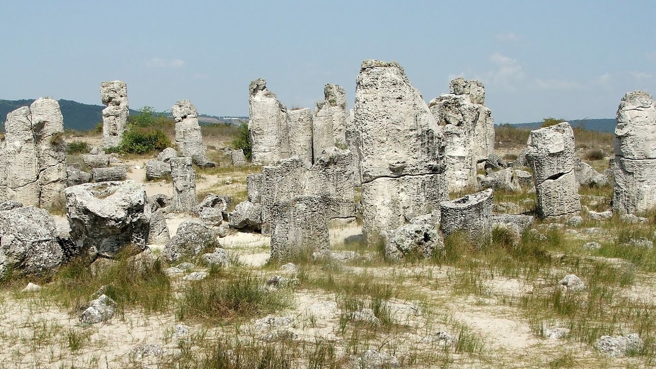
Pobiti Kamani (Stone Forest) - Slanchevo 133.05 km away
The Stone Forest of Bulgaria is located 18 km west of Varna, at the foothills of the Eastern Balkan Mountains. Its Bulgarian name, Pobiti Kamani, translates to planted stones, and it is referred to in English as the Stone Desert or Stone Forest.
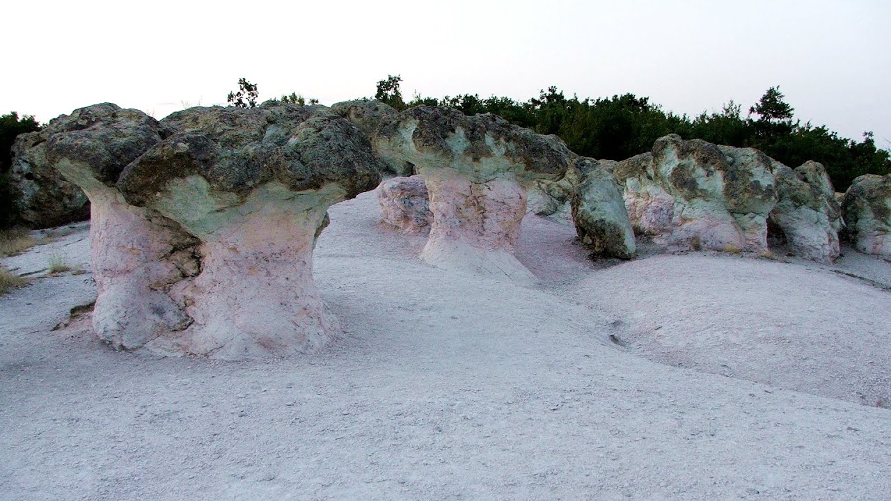
Kamenni Gabi (Stone Mushrooms) - Beli Plast 213.67 km away
The Stone Mushrooms (Kamenni Gabi) nature reserve in Bulgaria is situated east of the village of Beli Plast, along the road that connects Kardzhali to Haskovo. Spanning an area of 3 hectares, the reserve is home to several mushroom-shaped rock formations.
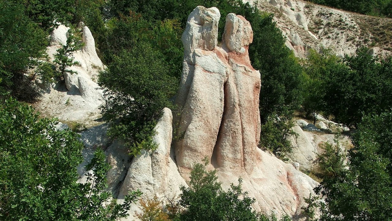
The Stone Wedding - Zimzelen, Kardzhali 219.01 km away
The Stone Wedding (Kamenna Svatba, Petrified Wedding, Kardzhali Pyramids) is located near the village of Zimzelen, close to the city of Kardzhali, in the eastern part of the Rhodope Mountains in Bulgaria. This spectacular natural formation was declared a natural monument in 1974.

Buzludzha monument - Kazanluk 226.4 km away
Buzludzha is a historically significant mountain located in the Central Balkan Mountains of Bulgaria. At its summit, at an altitude of 1432 meters above sea level, there is an abandoned monument.
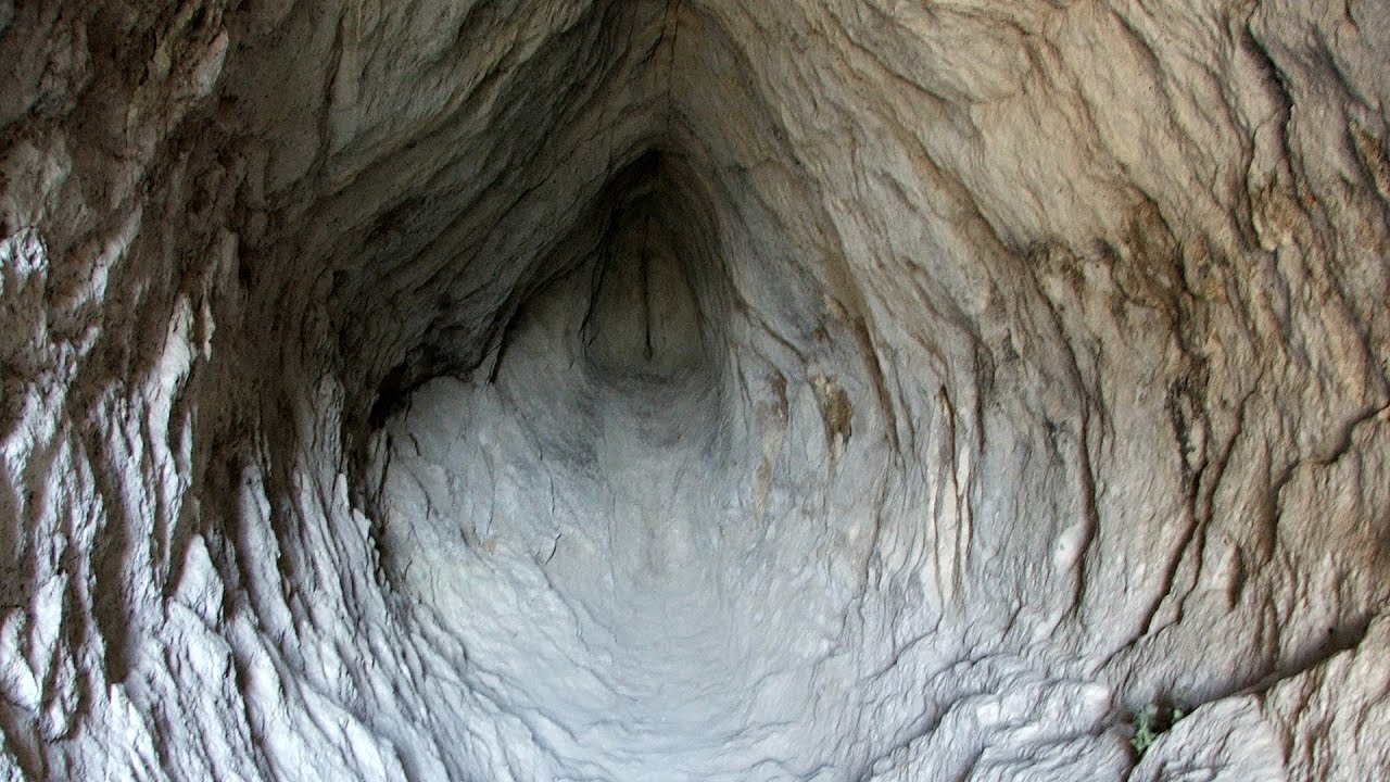
Vulva cave - Rhodope Mountains 230.24 km away
The Vulva Cave (Peshtera Utroba) is situated near the village of Nenkovo and the city of Kardzhali, in the Rhodope Mountains of Bulgaria. It derives its name from the shape of its entrance, which resembles a vulva.
Other places
Rossloch Klettersteig Leopoldsteiner See 1202.86 km away
The D/E difficulty Rossloch via ferrata is situated at the top of the 900-meter-high Seemauer cliff, overlooking the Leopoldsteiner See in the western part of the Hochschwab mountain range. It is designed for experienced via ferrata climbers, and complements the already impressive Emperor Franz Joseph via ferrata, as the two routes can be connected.
The D/E difficulty Rossloch via ferrata is situated at the top of the 900-meter-high Seemauer cliff, overlooking the Leopoldsteiner See in the western part of the Hochschwab mountain range. It is designed for experienced via ferrata climbers, and complements the already impressive Emperor Franz Joseph via ferrata, as the two routes can be connected.
Vulva cave Rhodope Mountains 230.24 km away
The Vulva Cave (Peshtera Utroba) is situated near the village of Nenkovo and the city of Kardzhali, in the Rhodope Mountains of Bulgaria. It derives its name from the shape of its entrance, which resembles a vulva.
The Vulva Cave (Peshtera Utroba) is situated near the village of Nenkovo and the city of Kardzhali, in the Rhodope Mountains of Bulgaria. It derives its name from the shape of its entrance, which resembles a vulva.
Doabra Stones Brezoi, Lotru Mountains 474.91 km away
The DN7A road branches off west from the Olt Valley, from the main road between Sibiu and Ramnicu Valcea, leading towards Voineasa and Lake Vidra. The first settlement is a small town, Brezoi, which is located at the confluence of the Lotru and Olt rivers.
The DN7A road branches off west from the Olt Valley, from the main road between Sibiu and Ramnicu Valcea, leading towards Voineasa and Lake Vidra. The first settlement is a small town, Brezoi, which is located at the confluence of the Lotru and Olt rivers.
Meziad cave Padurea Craiului Mountains 682.46 km away
The Meziad Cave is located near the village of Meziad, 22 km north of Beius, in the Padurea Craiului Mountains. It is one of our first tourist caves, its exploration is associated with the name of Gyula Czárán, cave researcher and writer.
The Meziad Cave is located near the village of Meziad, 22 km north of Beius, in the Padurea Craiului Mountains. It is one of our first tourist caves, its exploration is associated with the name of Gyula Czárán, cave researcher and writer.
Giant Ice Cave (Rieseneishöhle) Dachstein Salzkammergut, Obertraun am Hallstättersee 1277.88 km away
The second cave accessible to the public at the Schönbergalm above Obertraun on Lake Hallstatt is the Giant Ice Cave (Rieseneishöhle). For me, it was more spectacular than the Mammoth Cave.
The second cave accessible to the public at the Schönbergalm above Obertraun on Lake Hallstatt is the Giant Ice Cave (Rieseneishöhle). For me, it was more spectacular than the Mammoth Cave.
Planned destinations
Wild beach of Lipite South Sinemorets 0.27 km away
Where the sea meets the rocks Sinemorets 0.77 km away
Split Cliff (Razdelenata kanara) Sinemorets 1.35 km away
The Split Cliff, also known as Divided Rock, is an interesting rock formation located south of Sinemorets and north of Listi Beach. There is a trail along the plateau, starting from either Listi or Lipite Beach.
The Split Cliff, also known as Divided Rock, is an interesting rock formation located south of Sinemorets and north of Listi Beach. There is a trail along the plateau, starting from either Listi or Lipite Beach.
Listi bay and wild beach Sinemorets 1.79 km away
The Listi Beach is located between Lipite Beach and Silistar Beach. Historically, pirates had their hideouts along these shores.
The Listi Beach is located between Lipite Beach and Silistar Beach. Historically, pirates had their hideouts along these shores.
[ Top ↑ ]
[ Top ↑ ]
Copyright © 2003-2025 Trekkingklub and friends. Reproduction of any text, picture or video from this website, either in printed or electronic form, is prohibited without prior written permission. The given distances are to be understood as straight line distances, and are approximate. Website made in Miercurea Ciuc  .
.