The palm of God and the Heavens door - Fundatura Ponorului mountain village | Video


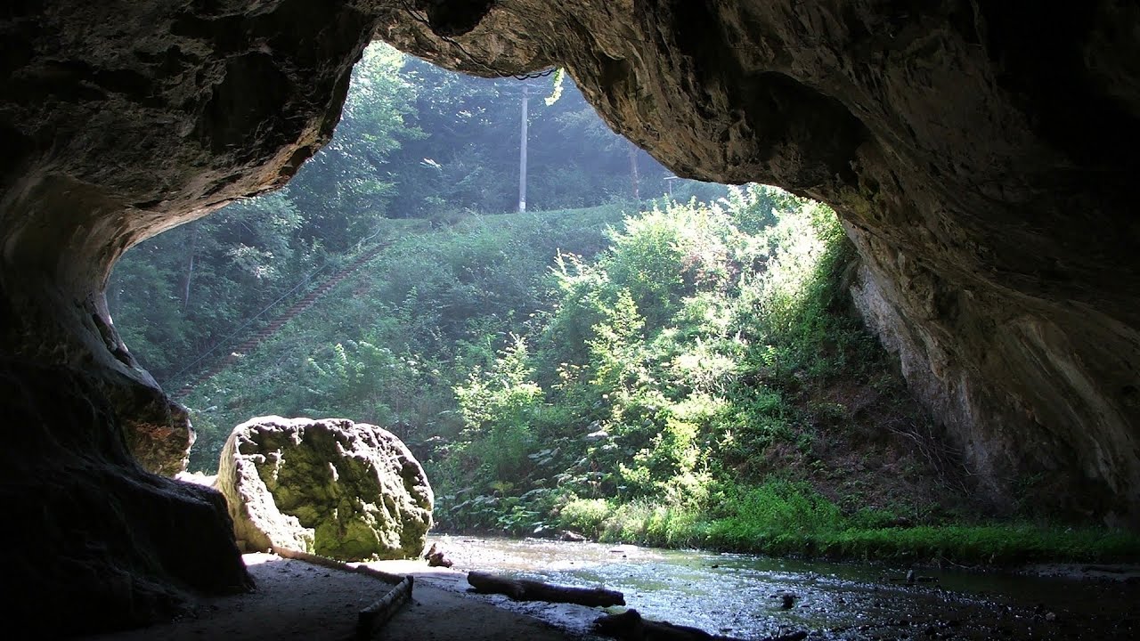
One of the most picturesque places in Romania, one of the most beautiful mountain villages, and a photographer's paradise. Fundatura Ponorului is located in the Ponor Stream Valley, part of the Gradistea Muncelului - Cioclovina National Park, in the Sureanu Mountains. Access is off the Hateg-Petrosani road, towards the villages of Ponor and Ohaba-Ponor. The road is paved up to the village of Federi.
Read more
Filmed with GoPro HERO5 Black. Music: Portrait of Time by Aakash Gandhi. Copyright © 2020 - 2026 Geo Trekker Videos. Please register for full and ad-free access.
Airport nearby: Caransebeş Airport (CSB - Caransebeş, Ro), 73 km away.
Photos of nearby places


Natural bridge next to the Banita Stone Quarry (12 photos) 13.6 km away. Although the Banita Stone Bridge is not far from the road that passes through the village, it is located beyond the railway line, so its approach is a bit cumbersome. We can go around the railway line on Carierei Street, and then we have to walk a few meters from the stone quarry.

Banita Gorge - Banita (16 photos) 15.6 km away. The approximately 250 m long gorge, similar to the Corcoaia Gorge, is truly spectacular. According to assumptions, it was formed by the collapse of a cave passage ceiling, and then the erosion formed spectacular karst formations in the limestone.

Boli Cave - Banita (20 photos) 15.8 km away. The main cave passage is approximately 460 m long, with an entrance portal that is 10 m high and 20 m wide at its base. In the 1960s, bridges were built over the underground stream flowing through the cave.


Parangul Mare peak (16 photos) 37.1 km away. Chamois saddle (Saua Caprelor), Carja mountain shelter (Refugiul Carja) - Carja peak (Varful Carja) - Stoienita peak (Varful Stoienita) - Gemanarea - Parangul Mare peak.


[ Top ↑ ]
Videos of nearby places

Crivadia Gorge 10.3 km away. The Crivadia Gorge is located next to the village of Crivadia, which belongs to Banita. Access is difficult, and the hike is made through the streambed, with water up to the waist at its narrowest point.

Banita Gorge and Banita rock bridge 15.6 km away. They say about this place that only very few people know about it, but that's not true. In fact, most nature lovers have heard of it, seen pictures taken here, even if not everyone has been able to come here.
Boli Cave - Banita 15.8 km away. The Boli Cave is located 6 km north of Petrosani, on the road that connects Hateg with the Jiu Valley. Here, the railway line that connects the two parts of Hunedoara County passes through, featuring a total of 66 curves and 8 tunnels.

Sheepdogs - Govora sheepfold - Retezat mountains 22.3 km away. On the second day of my weekend Retezat hike, I visited a sheepfold on the Lancita Ridge. To my great disappointment, they didn't make cheese or curd here.

Billy-goat lake, Closed Gates - Retezat Mountains 27.3 km away. The most unique ridge trail of the Retezat Mountains is the Closed Gates.Below, at an altitude of 2070 m above sea level, is the Billy-goat lake.
Other places
Hot Air Balloon Parade 2018 Campu Cetatii 188.2 km away. This year, the hot air balloons flew low over Campu Cetatii. The weather did not really favor the parade.
Tapolca lake cave Balaton-felvidéki National Park 464.7 km away. The Tapolca lake cave is situated in the Balaton-felvidéki National Park. A modern visitor center has been constructed at its entrance, featuring ten rooms that highlight the unique characteristics of karst regions.
Crystal Cave at Farcu Mine 152.1 km away. In the Padurea Craiului Mountains, near Rosia, in the Farcu bauxite mine, in 1987, the miners accidentally discovered a cave. It was filled with crystal-shaped limestone formations.
Lednica iron path Brestnitsa 289.8 km away. The Lednica via ferrata is located next to the Saeva Dupka Cave, near the village of Brestnitsa in Bulgaria. The trail leading to the via ferrata, which opened in 2007, starts from the cave parking lot next to a covered resting area.
Wild Ferenc memorial path Suhardul Mic 245.1 km away. In recent days, this news has been everywhere: the via ferrata route built on the southwest wall of Suhardul Mic (Little Suhard) has finally been completed and inaugurated. The new route has been named after Ferenc Wild, in memory of the former mountain rescuer, sports writer, and one of the founders of the mountain rescue association in Gheorgheni.
Ski resort Poiana Brasov Postavarul Mountains 185.6 km away. Shining sun and an Austria-feeling on the impeccable slopes of the ski paradise Poiana Brasov above Brasov. Sunbathing, coffee and refreshing drinks on the terrace of Julius Römer chalet.
Thracian stone sharapani Nochevo 439.9 km away. Sharapani is a traditional stone container used by ancient Thracians for processing grapes in wine production. Two well-preserved sharapani containers are located about 200 meters apart.
Iron path in winter Harghita Madaras 210.6 km away. This is already the sixth time I've climbed the via ferrata route set up on the rocky cliffs of Seii Peak near Harghita Madaras. Although the forecast suggests that the weather should be nice, I am greeted by a sky covered in clouds.
Rudariei watermills Eftimie Murgu 113 km away. I have visited the twenty-two wooden water mills with horizontal wheels, located in the valley of the Rudaria stream, mostly in the rain and under an umbrella. Some of them are still in use today.
Falco Peregrinus via ferrata Falcons Rock, Corbu 254 km away. Falco Peregrinus (Peregrine falcon) via ferrata (B/C) - Falcon's Rock, Corbu.
Deubels path Piatra Craiului Mountains 158.3 km away. Deubels path - Piatra Craiului Mountains (Kings Rock).
Suchurum waterfall Karlovo 347.7 km away. The 15-meter-high Suchurum Waterfall is located at the foot of the Stara Planina mountain range, 1 km north of the town of Karlovo in Bulgaria. It is situated below the Karlovo hydroelectric power plant, on the waters of the Stara Reka stream.
Sleeping Beauty cave 387.3 km away. Shpella e Radacit (Sleeping Beauty) cave.
Sumuleu-Ciuc in winter 225.9 km away. Sumuleu-Ciuc (Csíksomlyó) in winter.
Bicajel Gorge Hasmas Mountains 247.9 km away. Bicajel Gorge (Cheile Bicajelului) - Hasmas Mountains.
Other destinations
Gornjak via ferrata and Kudelinovs fortress Zdrelo 192 km away. Difficulty level C/D, total length: 400 m, height difference: 330 m, year of construction: 2019, total length of the route to Kudelinov's fortress: 1100 m. Access to the via ferrata is free.
[ Top ↑ ]
Copyright © 2003-2026 Trekkingklub and friends. Reproduction of any text, picture or video from this website, either in printed or electronic form, is prohibited without prior written permission.
The given distances are to be understood as straight line distances, and are approximate. Website made in Miercurea Ciuc  .
.