Penang war museum | Video
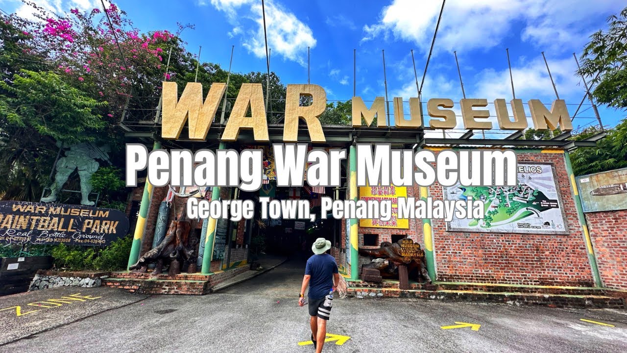
Located in Batu Maung, the Penang War Museum is a 1930s British Army fort. During the 1941 Japanese invasion, Penang was evacuated without a shot fired, and the fort was used by Japan in the war.
Read more
Login (register) for the full descriptions, and access to the photos and videos.
Airport nearby Penang International Airport (PEN - Penang, My), 2 km away from Penang war museum.
Photos of nearby places

Fortress Kariya and the Lighthouse on Cape Shabla (0 photos) Shabla's lighthouse marks the easternmost point of Bulgaria. With its 32-meter height, it is the oldest and tallest lighthouse on the Black Sea.

Stone Sea and Little Sea beach - Shabla (10 photos) Monument of fallen Soviet aviators (May 17, 1944), Stone Sea and Little Sea beach - Shabla.

The coast of the Black Sea north of Tyulonovo (36 photos) The Portal, the Salt Pools, the Wild Frog's Point, the Seal Cave, the Passage and the Whale.

Tyulenovo Cliffs and the Rock Arch (23 photos) The coast of Tyulenovo consists of a complex of sheer reefs, steep sea cliffs, and natural and artificial sea caves. There are picturesque beaches and rocky coasts, along with adjacent marine areas, both north and south of Tyulenovo.

Fishermens harbor - Tyulenovo (14 photos) Tyulenovo church, Monument to Lieutenant Valentin Terziev, Fishermen's harbor. Tyulenovo translates to Village of Seals in Bulgarian, although seals have not been observed in the area since the 1980s.

The coast of the Black Sea south of Tyulenovo (10 photos) The coast of the Black Sea south of Tyulenovo.

The cave with the metal ladder - Tyulenovo (27 photos) The cave with the metal ladder (Peshterata s metalnata stalba) - Tyulenovo.

Bird Observatory at Shabla Tuzla Lake (11 photos) Three coastal lakes - Shabla, Ezerets, and Shabla Tuzla - support a great variety of plants and animals. The lakes are especially important in winter, and they are protected to provide a refuge for their unique wildlife.

Ezerets beach - Shabla, Dobrich (10 photos) The beach near the village of Ezerets is semi-wild, relatively quiet and clean, without sunbeds or umbrellas. The sand is fine-grained, and the water is clear.


The Gate of the 40 Virgins (12 photos) The Gate of the 40 Virgins, The monument to Admiral Ushakov on Cape Kaliakra.

The rocky coast of the Black Sea - Rezovo (23 photos) The coast of Rezovo village, which includes the Smooth Rocks (Gladkite Skali) and the Old Pier (Stariat Kei), is one of the most stunning rocky coastlines along Bulgaria's Black Sea coast.

Smooth Cliffs - Rezovo (12 photos) Smooth Cliffs (Smooth Rocks, Gladkite Skali) - Rezovo. Uniquely polished and smooth, these rocks near Rezovo stand out among the rough, sharp-edged rock formations along Bulgaria's Black Sea coast.

The Old Pier - Rezovo (16 photos) The Old Pier (Stariat_Kei) is a historic structure that has served as a point for fishing and transportation. Today, it is a destination for visitors seeking tranquility, beautiful natural surroundings, and picturesque sea views.

Rezovo, Bulgarias Southeasternmost Coastal Village (14 photos) Located in southeastern Bulgaria on the Bulgaria-Turkey border, Rezovo is a picturesque seaside village and resort at the southernmost tip of the Bulgarian Black Sea Coast. It is notable for its position overlooking the Turkish bank of the Rezovo River.


Stone bathtub - Small Kastrich Beach (10 photos) Stone bathtub (Kamenna Vana) - Small Kastrich Beach (Plazh malak Kastrich).


The Rock Gate and the Red Bay - Rezovo (8 photos) The Rock Gate (Skalnata porta) and the Red Bay (Cherveniat zaliv) are located at the southeastern end of Silistar Beach. Here, two massive rock formations rise from the water, forming a gate.

Silistar Beach - Rezovo (4 photos) Located 5 km south of Sinemorets, on the way to Rezovo, you'll find the turn-off to the last beach before the Turkey border. After approximately 1 km of dirt road winding through a forest, you'll arrive at a parking area.

Listi bay and wild beach - Sinemorets (15 photos) The Listi bay (Zaliv Listi) and wild beach (Plazh Listi) is located between Lipite Beach and Silistar Beach. In the past, pirates hid on these shores.
[ Top ↑ ]
Videos of nearby places
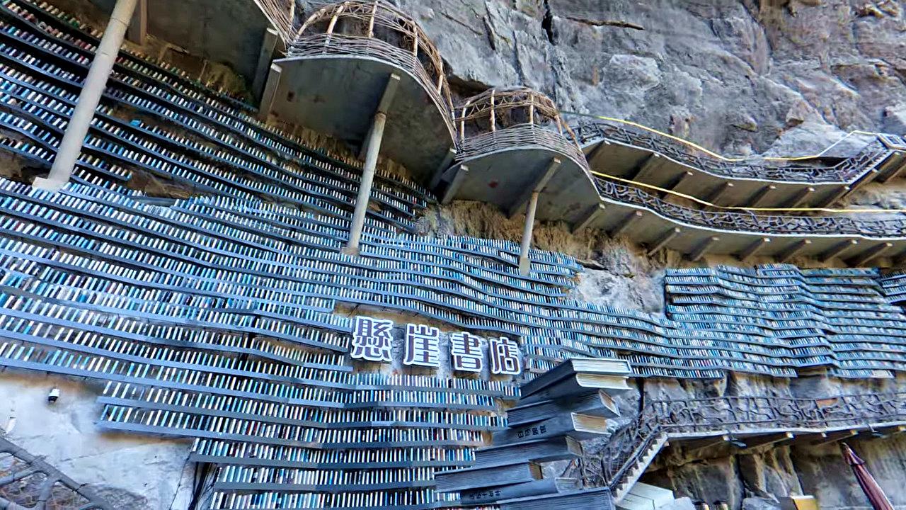
Cotton Sinkhole hanging library Cotton Sinkhole (Mianhua tian keng) hanging library - Luocheng Mulao Autonomous County, Hechi city, Guangxi Zhuang Autonomous Region. Inside of this large grotto, the Cotton Sinkhole, there is a unique library hanging on the side of the rock wall, with rock-hanging wooden walkways and balconies.

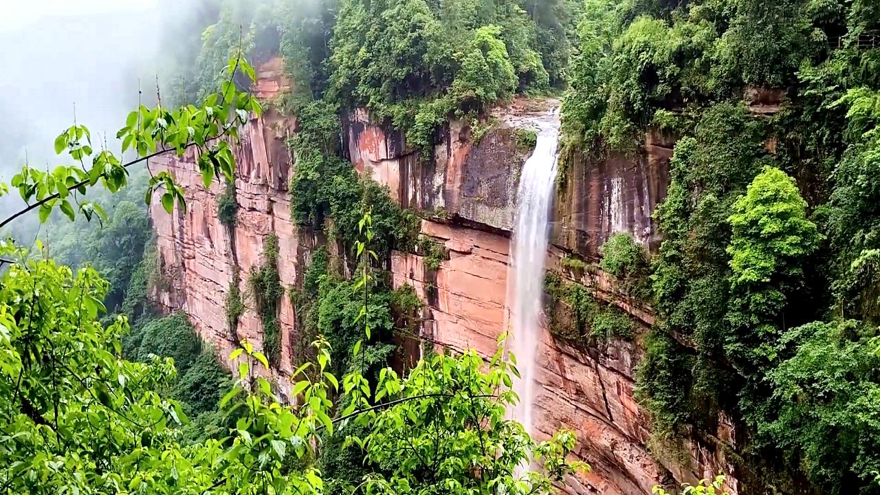
Balcony of Nostalgia Waterfall - Simian Mountain Balcony of Nostalgia (Wangxiangtai) Waterfall - Simian Mountain, Jiangjin District, Chongqing. The 150 m high and 40 m wide waterfall is the world's largest heart-shaped waterfall.
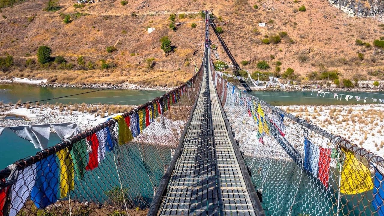
Punakha suspension bridge - Bhutan The Punakha Suspension Bridge, stretching 160 meters, is one of the longest and oldest suspension footbridges in Bhutan. Situated near the Pungthang Dechen Phodrang Dzong, it spans the Pho Chhu (Male River), one of Bhutan's major rivers.
[ Top ↑ ]
Copyright © 2003-2026 Trekkingklub and friends. Reproduction of any text, picture or video from the Penang war museum website, either in printed or electronic form, is prohibited without prior written permission.
The given distances are to be understood as straight line distances, and are approximate. Website made in Miercurea Ciuc  .
.