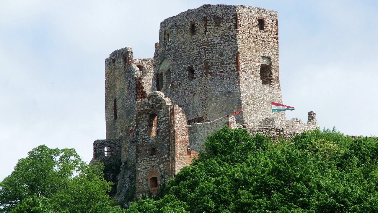
Siklós castle

The Siklós Castle is an important historical landmark in Hungary, its fortress walls were laid around 1260, with the first written record dating back to 1294. The fortification, built on a low elevation, features an inner tower, an irregular floor plan, and consists of both an outer and an inner fortress.
Read more
Planned destination. Copyright © Trekkingklub
Photos of nearby places

Slunjcica - Rastoke, Slunj - Croatia (12 photos) 226.25 km away
The Slunjcica river is situated in central Croatia, flowing through the Kordun region. The city of Slunj is named after this river.

Plitvice Lakes - Croatia (60 photos) 234.82 km away
The Plitvice Lakes National Park is the oldest and largest national park in Croatia. It is located in a mountainous region between Mala Kapela and Licka Pljesivica.

Manita pec cave - Croatia (21 photos) 279.71 km away
There are 115 caves so far known in the Paklenica National Park, Manita pec is the most famous one, and is open to the public for guided visits. The cave has beautiful chambers, and various cave formations such as stalagmites, stalactites, columns, and flowstones.

Paklenica National Park - Croatia (55 photos) 282.2 km away
In 1949, the area of Velika and Mala Paklenica was designated as a national park due to its natural features, forests, and geomorphologic structures. The main purpose was to protect the largest and best-preserved forest complex in Dalmatia, which was at risk from excessive exploitation.


[ Top ↑ ]
Videos of nearby places
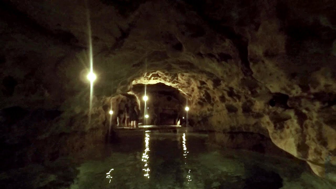
Tapolca lake cave - Balaton-felvidéki National Park 131.96 km away
The Tapolca lake cave is situated in the Balaton-felvidéki National Park. A modern visitor center has been constructed at its entrance, featuring ten rooms that highlight the unique characteristics of karst regions.
Castle panorama route, Zoltán Tálos memorial route, Besieger's route - Csesznek 169.75 km away
Castle panorama route (D), Zoltán Tálos memorial route (E), Besieger's route (C), Kőmosó-ravine, Csesznek, Veszprém county, Hungary. The via ferratas in Csesznek are suitable for both getting acquainted with climbing, and assessing our capabilities.
Other places
Kaiser Franz-Josef Klettersteig Leopoldsteiner See 324.94 km away
The Franz-Josef Klettersteig is located on the Seemauer cliff face, which rises 900 meters above Leopoldsteiner Lake, in the western part of the Hochschwab mountain range, just 4 km from the town of Eisenerz. This via ferrata is named after the Kaisersteig, a hunting trail established for the esteemed Emperor Franz Joseph I of Austria and Hungary at the end of the 19th century, traces of which can still be observed today.
The Franz-Josef Klettersteig is located on the Seemauer cliff face, which rises 900 meters above Leopoldsteiner Lake, in the western part of the Hochschwab mountain range, just 4 km from the town of Eisenerz. This via ferrata is named after the Kaisersteig, a hunting trail established for the esteemed Emperor Franz Joseph I of Austria and Hungary at the end of the 19th century, traces of which can still be observed today.
Mill of the Devils (Moara Dracilor) Tasna Gorge (Cheile Tasnei) 343.47 km away
The Tasna Gorges are located in the Mehedinti Mountains, approximately 15 km from the resort of Baile Herculane. The gorges are part of the Domogled - Cerna Valley (Valea Cernei) National Park.
The Tasna Gorges are located in the Mehedinti Mountains, approximately 15 km from the resort of Baile Herculane. The gorges are part of the Domogled - Cerna Valley (Valea Cernei) National Park.
Via Ferrata Fairy Castle (Castelul Zanelor, Casa Zmeului, The House of the Dragon) Vadu Crisului 346.45 km away
South of Vadu Crisului, in the Padurea Craiului Mountains, lies the Vadu Crisului Gorge, a section of the Crisul Repede river that narrows between rocky walls. In the Middle Ages, there was intense log transportation activity here, and the transport of salt and timber to Hungary passed through this area.
South of Vadu Crisului, in the Padurea Craiului Mountains, lies the Vadu Crisului Gorge, a section of the Crisul Repede river that narrows between rocky walls. In the Middle Ages, there was intense log transportation activity here, and the transport of salt and timber to Hungary passed through this area.
Leopoldsteiner lake Eisenerz, Steiermark 324.42 km away
Leopoldsteiner See is located in Styria, 4 km northwest of the town of Eisenerz. It lies at an elevation of 628 meters above sea level in the western part of the Hochschwab mountain range, at the foot of the Seemauer cliff.
Leopoldsteiner See is located in Styria, 4 km northwest of the town of Eisenerz. It lies at an elevation of 628 meters above sea level in the western part of the Hochschwab mountain range, at the foot of the Seemauer cliff.
Crystal Cave at Farcu Mine 334.57 km away
In the Padurea Craiului Mountains, near Rosia, in the Farcu bauxite mine, in 1987, the miners accidentally discovered a cave. It was filled with crystal-shaped limestone formations.
In the Padurea Craiului Mountains, near Rosia, in the Farcu bauxite mine, in 1987, the miners accidentally discovered a cave. It was filled with crystal-shaped limestone formations.
Planned destinations
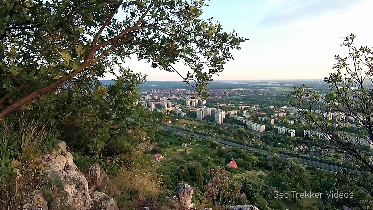
Lookout Kis-Tubes Western Mecsek 28.68 km away
The lookout platform at Kis-Tubes, located at an altitude of 577 meters, was built in 1959, and offers a magnificent panorama of Pécs at the foot of the hills. The concrete lookout, situated on the western side of the Kis-Tubes peak along the ridge connecting Misina to Tubes, was designed by Tibor Kiss.
The lookout platform at Kis-Tubes, located at an altitude of 577 meters, was built in 1959, and offers a magnificent panorama of Pécs at the foot of the hills. The concrete lookout, situated on the western side of the Kis-Tubes peak along the ridge connecting Misina to Tubes, was designed by Tibor Kiss.
Jacob Hill Lookout Western Mecsek 29.39 km away
Jacob Hill is a popular hiking destination in Western Mecsek, with an elevation of 592 m. At the top, there are the ruins of a Pauline monastery and a lookout tower.
Jacob Hill is a popular hiking destination in Western Mecsek, with an elevation of 592 m. At the top, there are the ruins of a Pauline monastery and a lookout tower.
Agnes Waterfall Western Mecsek 32.92 km away
The Agnes Waterfall is the largest waterfall in the Mecsek region, although the stream's water only cascades down from a height of one and a half to two meters, over a travertine ledge. Nearby attractions include the Meleg-mány Waterfall and the Mánfa Stone-Cave.
The Agnes Waterfall is the largest waterfall in the Mecsek region, although the stream's water only cascades down from a height of one and a half to two meters, over a travertine ledge. Nearby attractions include the Meleg-mány Waterfall and the Mánfa Stone-Cave.
Balázs Hill Lookout Western Mecsek 34.03 km away
The Balázs hill lookout, located at an altitude of 320 meters, offers a beautiful view of Lake Pécs and the wooded mountain ranges of Western Mecsek. The original lookout, built in 1975, was destroyed by fire, and it was rebuilt in 2001 using a metal structure, which was renovated in 2014.
The Balázs hill lookout, located at an altitude of 320 meters, offers a beautiful view of Lake Pécs and the wooded mountain ranges of Western Mecsek. The original lookout, built in 1975, was destroyed by fire, and it was rebuilt in 2001 using a metal structure, which was renovated in 2014.
[ Top ↑ ]
[ Top ↑ ]
Select language: - Magyar - Romana - Deutsch - Français - Italiano - Español - Български - 中文 - Copyright © 2003-2025 Trekkingklub and friends. Reproduction of any text, picture or video from this website, either in printed or electronic form, is prohibited without prior written permission. The given distances are to be understood as straight line distances, and are approximate. Website made in Miercurea Ciuc