Bicajel Waterfall - Bicajel Gorge | Photos


Page no. 1, photos: 1-6, 10 photos in total. >>>

Copyright © 2010 - 2026 Trekkingklub.com. Please register for full and ad-free access.
Airport nearby: Bacău George Enescu International Airport (BCM - Bacău, Ro), 88 km away.
Photos of nearby places


[ Top ↑ ]
Videos of nearby places
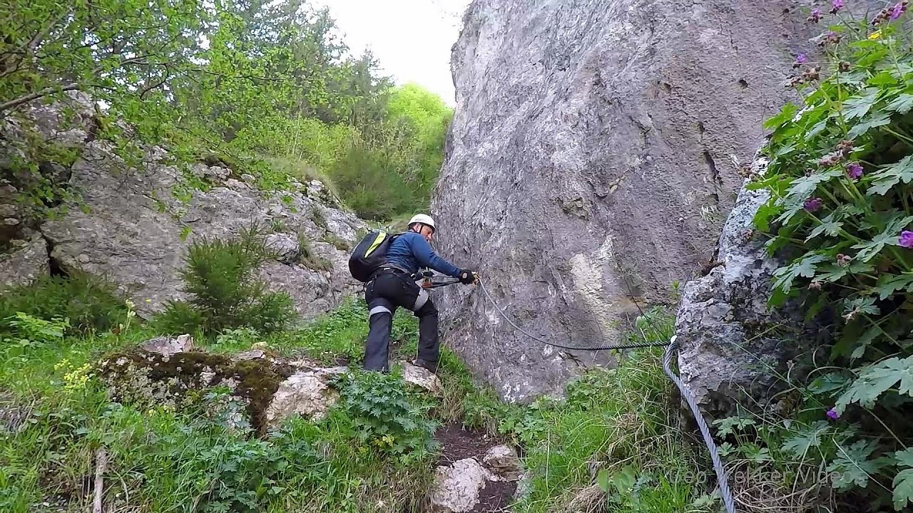
Bicajel Gorge - Hasmas Mountains 0.3 km away. Bicajel Gorge (Cheile Bicajelului) - Hasmas Mountains.
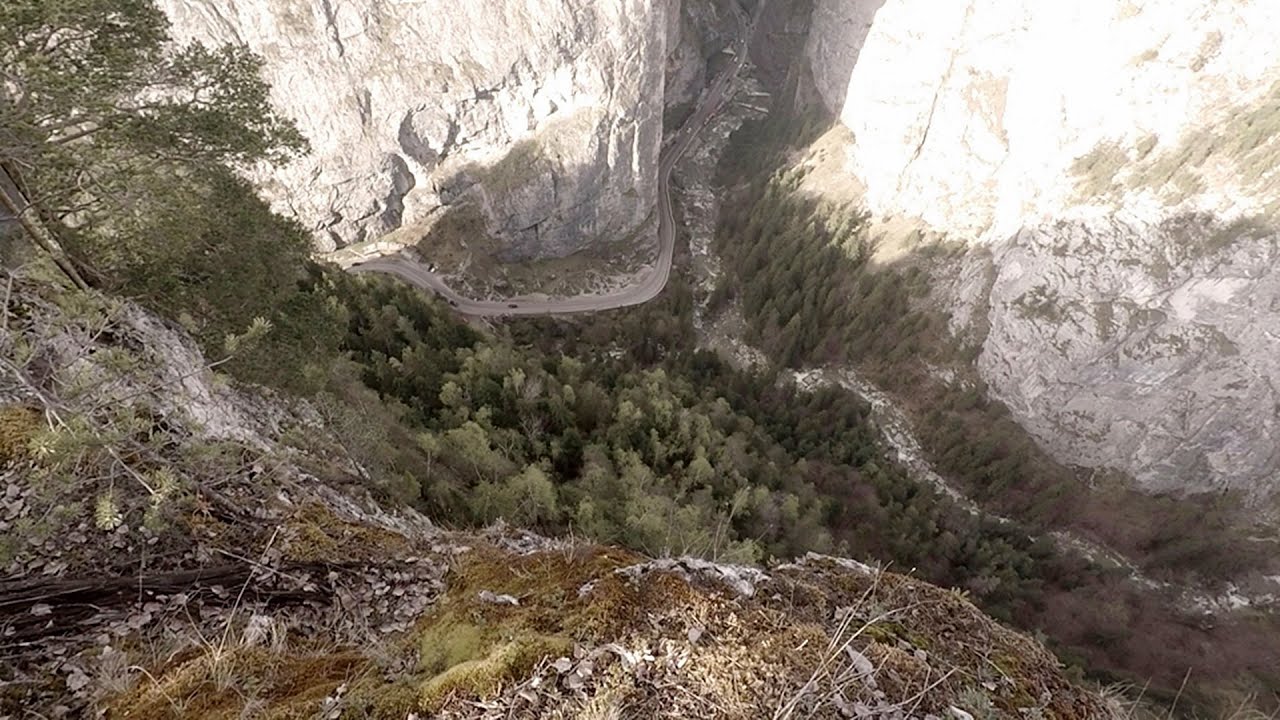
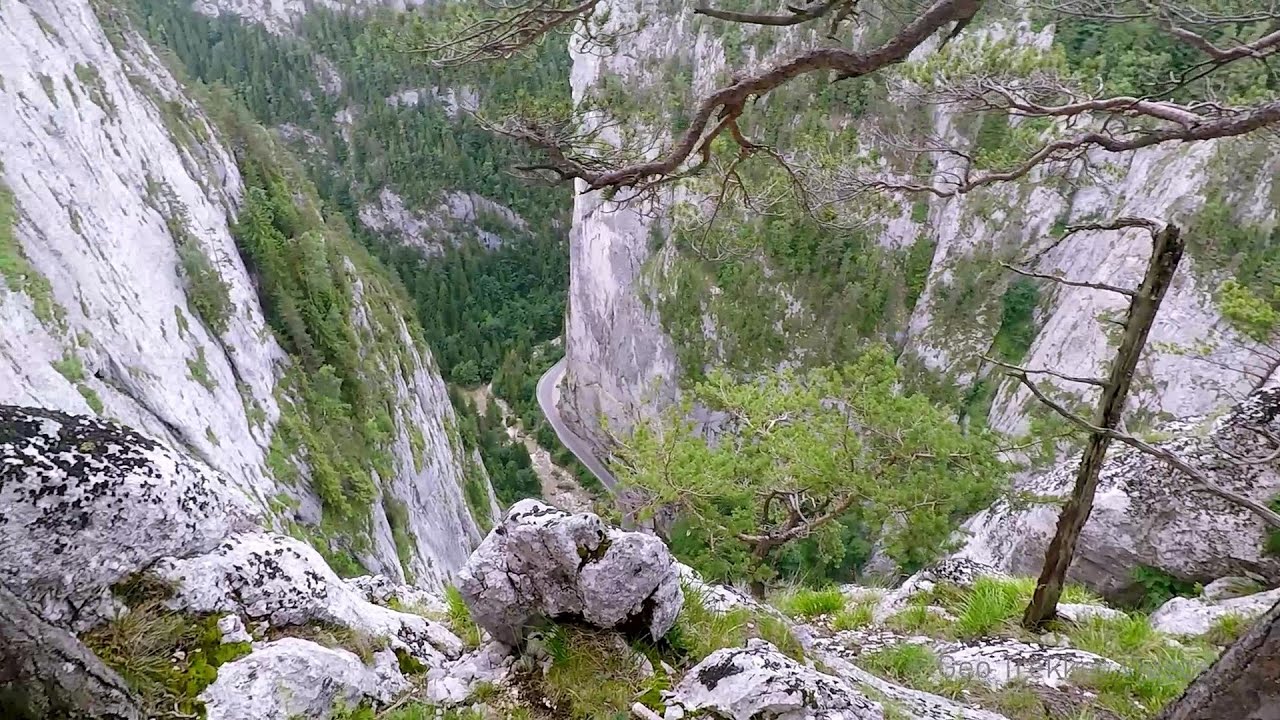
Poienii Rock, north-eastern lookout point - Bicaz Gorge 0.5 km away. From the viewpoint at the top of the northeastern wall of Poienii Rock in the Bicaz Gorges, we can look down 300 meters to the mouth of the Bicajel stream. The Bridge of the Hungarians is hidden among pine trees.
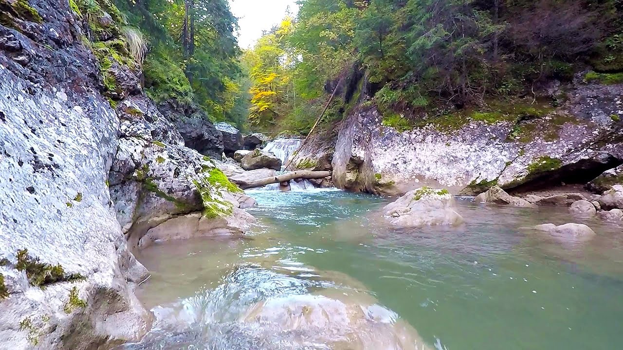
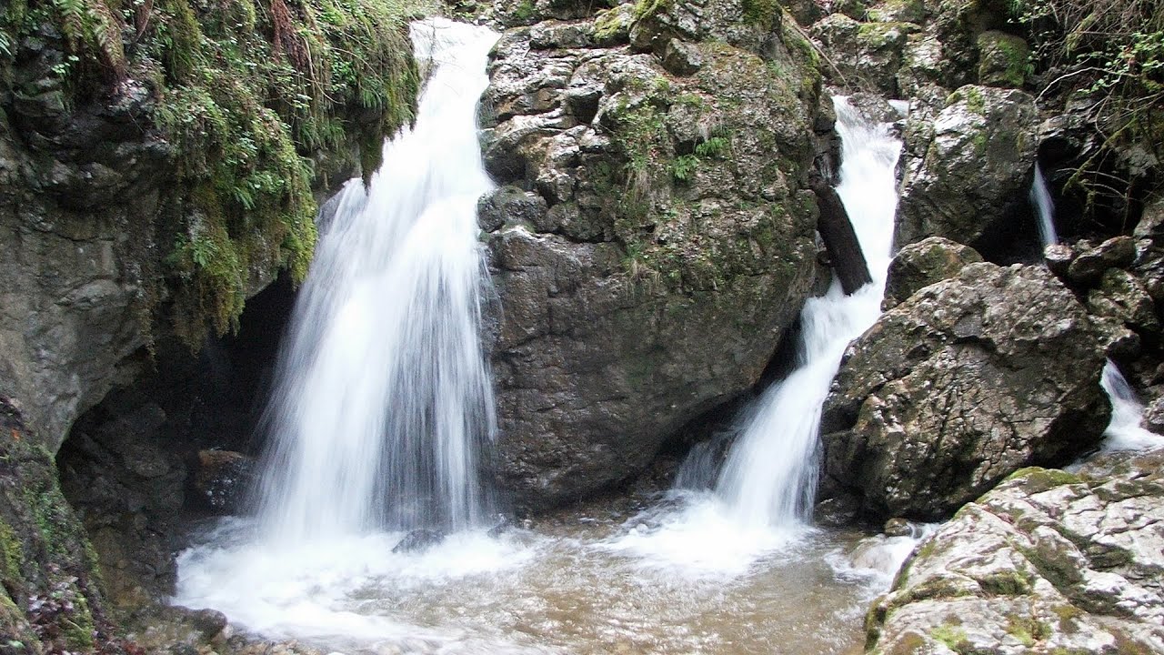
Bicajel Gorge, Bicajel Waterfall, Stone of the Gorge 0.8 km away. Bicajel Gorge (Cheile Bicajelului), Bicajel Waterfall (Cascada Bicajel), Stone of the Gorge (Surduc Stone, Piatra Surducului) - Hasmas Mountains.
Waterfalls of Lapos creek - Bicaz Gorge 1.4 km away. One of the lesser-known attractions of the Bicaz Gorges is the series of waterfalls along Lapos Creek. This creek flows between Cupas Stone and Bardos Stone before eventually merging with Bicaz Creek, forming spectacular waterfalls beneath the Altar Stone.
Sugau Stone lookout point and iron path, Sugau Gorge - Munticelu 2.7 km away. Sugau Stone lookout point and iron path (B/C), Sugau Gorge - Munticelu Nature Reserve.
Other places
Lednica iron path Brestnitsa 437.7 km away. The Lednica via ferrata is located next to the Saeva Dupka Cave, near the village of Brestnitsa in Bulgaria. The trail leading to the via ferrata, which opened in 2007, starts from the cave parking lot next to a covered resting area.
Boli Cave Banita 245.1 km away. The Boli Cave is located 6 km north of Petrosani, on the road that connects Hateg with the Jiu Valley. Here, the railway line that connects the two parts of Hunedoara County passes through, featuring a total of 66 curves and 8 tunnels.
Piticot iron path for children Suncuius 250 km away.
Transalpina Ski Resort Vidra lake 225.1 km away.
Rudariei watermills Eftimie Murgu 360.4 km away. I have visited the twenty-two wooden water mills with horizontal wheels, located in the valley of the Rudaria stream, mostly in the rain and under an umbrella. Some of them are still in use today.
Oltet Gorge Capatana Mountains 238.3 km away. Oltet Gorge (Cheile Oltetului) - Capatana Mountains. That day, we had planned to ski at the Ranca resort, situated alongside the Transalpina high altitude mountain road in the Parang Mountains.
Gornjak via ferrata and Kudelinovs fortress Zdrelo 437.6 km away. Difficulty level C/D, total length: 400 m, height difference: 330 m, year of construction: 2019, total length of the route to Kudelinov's fortress: 1100 m. Access to the via ferrata is free.
Snow-covered valley of Balea and the Transfagarasan in winter The ascent 160.5 km away. The Fagarasi Mountains can be easily approached from the north, mainly by using the Transfagarasan Road. This high altitude mountain road is only accessible during the summer months (throughout its entire length).
Kaya Bunar Hotnitsa 407.8 km away. The Kaya Bunar Waterfall (Hotnishki Vodopadi, Hotnitsa Waterfall) is located 20 km from the city of Veliko Tarnovo in Bulgaria. The waterfall is 30 meters high, and there are several smaller cascades above it.
Big Via ferrata Rasnoavei Gorge 142.2 km away. The most dangerous Eastern European iron path, and also one of the most beautiful via ferrata routes in Romania, is in the Rasnoavei Gorges, Postavaru Mountains.The route is 450 m long, with a level difference of 220 m.
Mine lake Megyer mountain, Sárospatak 362.8 km away. The via ferrata routes of the Megyer mountain mine lake. The geologists' path E 25 m, Szabó József-memorial path C 200 m, Amphitheater D 40 m, Devil's Cauldron E 70 m, Sweet aquatic life D 150 m, Velociraptor C 35 m.
Loreley and Pink Panther iron path Baia de Fier 240.5 km away. The Loreley via ferrata (graded B/C, with an elevation difference of approximately 100 m and a length of about 100 m) is located on the rock wall on the opposite side of the road. A branch from its upper section leads to the Pink Panther (Pantera Roz, graded A/B/C, approximately 200 meters long, with an elevation difference of about 50 meters).
Ramet Gorge Goagiu Creek 189.3 km away. Ramet Gorge (Cheile Rametului) - Goagiu Creek (Paraul Goagiu), Trascau Mountains. The Ramet Gorge is the wildest canyon in the Trascau Mountains.
Shipka pass Shipka 453 km away. The Shipka Pass is one of the most spectacular crossings of the Balkan Mountains, and is part of the Bulgarka Nature Park. It separates the provinces of Gabrovo and Stara Zagora, and provides a connection between the cities of Gabrovo and Kazanlak.
Billy-goat lake, Closed Gates Retezat Mountains 274.8 km away. The most unique ridge trail of the Retezat Mountains is the Closed Gates.Below, at an altitude of 2070 m above sea level, is the Billy-goat lake.
[ Top ↑ ]
Copyright © 2003-2026 Trekkingklub and friends. Reproduction of any text, picture or video from this website, either in printed or electronic form, is prohibited without prior written permission.
The given distances are to be understood as straight line distances, and are approximate. Website made in Miercurea Ciuc  .
.