The Rock with a Hole - Corund | Photos


Page no. 1, photos: 1-6, 6 photos in total.

The Likas Stone (The Rock with a Hole) is located near Corund, on a meadow next to the road and four graves. In the middle of the conglomerate rock block, there is a perfectly drilled, heart-shaped hole. From one side, the Likas Stone looks like a dinosaur, while from another side, it resembles a seal.
Copyright © 2007 - 2026 Trekkingklub.com. Please register for full and ad-free access.
Airport nearby: Transilvania International Airport (TGM - Recea, Ro), 61 km away.
Photos of nearby places


Small Pine Stone - Gurghiu Mountains (8 photos) 12.5 km away. Small Pine Stone (Kisfenyős Stone) - Gurghiu Mountains.


Shepherd Stone - Gurghiu Mountains (8 photos) 15.3 km away. Shepherd Stone (Pakulárkő, Piatra Pacurarului) - Gurghiu Mountains.


Rák lake - Porumbenii Mari (15 photos) 18.8 km away. The Rak lake is located 2 km north of the village Porumbenii Mari, at 600 m altitude. The circumference of the lake is 800 m, the length 250 m, width 150 m, maximum depth 7 m, and the surface is 28000 m2 (10 ha together with the joined area).

[ Top ↑ ]
Videos of nearby places

The Heart of Jesus look-out - Lupeni 7.3 km away. Through the mud on Gordon Mountain, above Farkaslaka (Lupeni commune, Harghita county, Transilvania), on a cloudy afternoon, at the end of February. The destination is the Heart of Jesus lookout, nicknamed as Pléhkrisztus (The Tin Christ).

Iron path - Harghita-Madaras 26.8 km away. Amateur filming in Harghita-Madaras, holding the camera by hand in the car, and helmet-mounted on the via ferrata. I climbed an iron path for the first time in my life on the Nyerges cliffs (Stancile Seii), I didn't have the right equipment yet.

Iron path in winter - Harghita Madaras 26.8 km away. This is already the sixth time I've climbed the via ferrata route set up on the rocky cliffs of Seii Peak near Harghita Madaras. Although the forecast suggests that the weather should be nice, I am greeted by a sky covered in clouds.
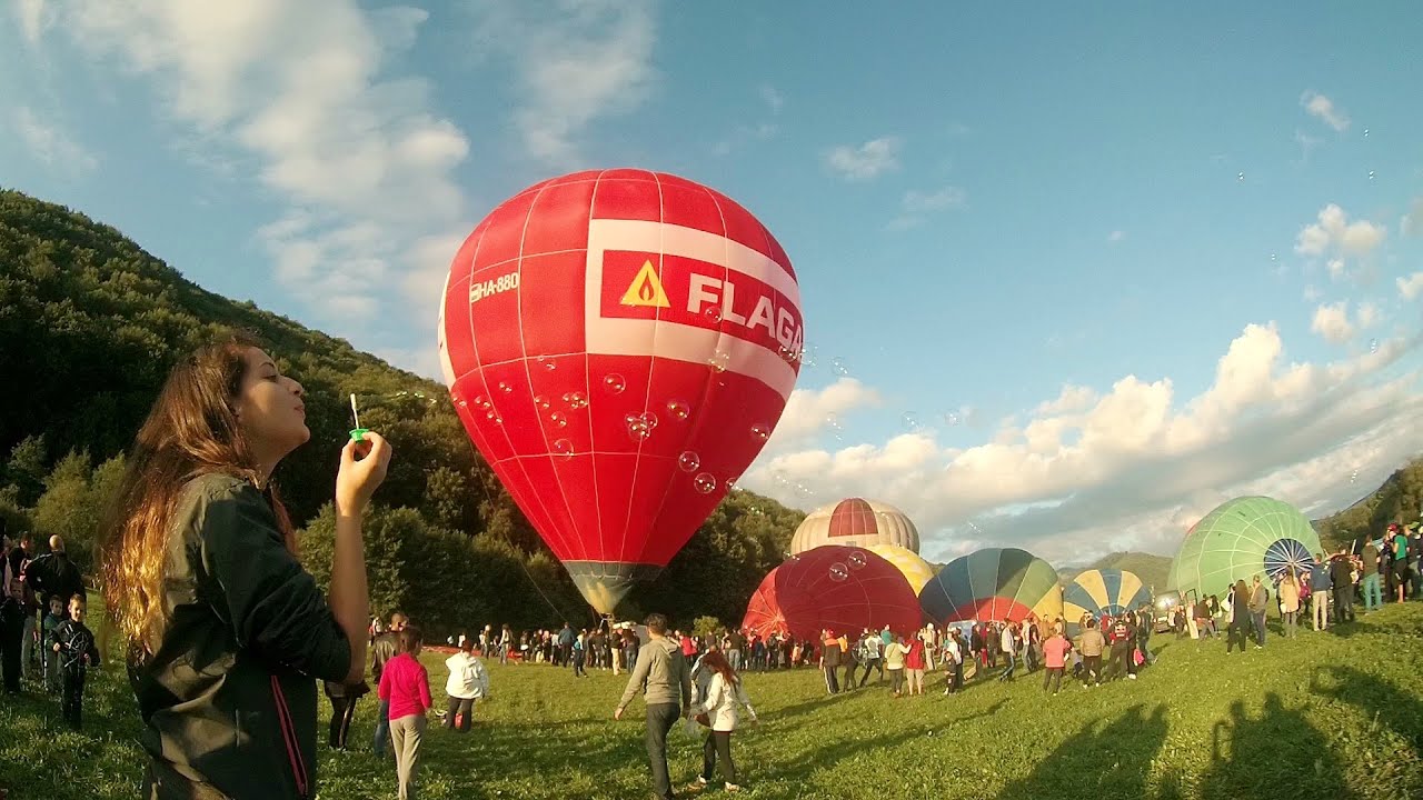
Hot air balloon parade 2015 - Campu Cetatii 28.9 km away. This year, the Hot Air Balloon Parade was organized in Campu Cetatii for the tenth time. Unfortunately, the weather only allowed for flying on Saturday morning and evening.
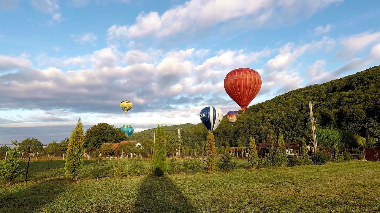
Hot Air Balloon Parade 2018 - Campu Cetatii 28.9 km away. This year, the hot air balloons flew low over Campu Cetatii. The weather did not really favor the parade.
Other places
Sheepdogs Govora sheepfold Retezat mountains 208.5 km away. On the second day of my weekend Retezat hike, I visited a sheepfold on the Lancita Ridge. To my great disappointment, they didn't make cheese or curd here.
Rudariei watermills Eftimie Murgu 299.3 km away. I have visited the twenty-two wooden water mills with horizontal wheels, located in the valley of the Rudaria stream, mostly in the rain and under an umbrella. Some of them are still in use today.
Womens Spiral, Cave Ridge, and The Great Crack iron paths Baia de Fier 180.1 km away. Perhaps the most interesting via ferrata among the routes in the Baia de Fier area is the Womens Spiral. After completing it, I can say that it is the second most thrilling via ferrata in Romania, following the Big Via Ferrata at Rasnov.
Boli Cave Banita 183.9 km away. The Boli Cave is located 6 km north of Petrosani, on the road that connects Hateg with the Jiu Valley. Here, the railway line that connects the two parts of Hunedoara County passes through, featuring a total of 66 curves and 8 tunnels.
Deubels path Piatra Craiului Mountains 102.9 km away. Deubels path - Piatra Craiului Mountains (Kings Rock).
Abandoned Sports Hall Varna 419.7 km away. An abandoned sports hall in Varna, with an unfinished dormitory and tennis courts across three levels.
Devils Mill Gorge Campulung Moldovenesc 117.6 km away. The Devil's Mill Gorge is relatively short, measuring only 60 to 70 meters in length. It was formed in yellowish-gray-white dolomite by the work of a stream that crosses the gorge, as a result of erosion and the dissolution characteristic of limestone.
Saeva Dupka cave Brestnitsa 387.2 km away. The Saeva Dupka Cave is located 2 km south of the village of Brestnitsa. In its five chambers and 400 meters of passageways, you can see the most beautiful cave formations in Bulgaria.
Bovska Skaklya waterfall Iskar gorge 408 km away. The Bovska Skaklya waterfall is located near the town of Svoge in Bulgaria. The waterfall formed on the Zaselska River has several reported heights online (120 m, 85 m).
Belogradchik fortress 372.3 km away. Belogradchik is located in the northwestern part of Bulgaria, in the Vidin Province, at the foot of the Balkan Mountains, near the Serbian border. Its name means little white town.
Abandoned copper mine Tsar Asen, Pazardzhik 460.6 km away. The turquoise waters of this mine lake are extremely beautiful but dangerously poisonous. Do not descend to the shore or touch the water!
Snow-covered valley of Balea and the Transfagarasan in winter The ascent 102.1 km away. The Fagarasi Mountains can be easily approached from the north, mainly by using the Transfagarasan Road. This high altitude mountain road is only accessible during the summer months (throughout its entire length).
Suchurum waterfall Karlovo 423.6 km away. The 15-meter-high Suchurum Waterfall is located at the foot of the Stara Planina mountain range, 1 km north of the town of Karlovo in Bulgaria. It is situated below the Karlovo hydroelectric power plant, on the waters of the Stara Reka stream.
Banita Gorge and Banita rock bridge 184.5 km away. They say about this place that only very few people know about it, but that's not true. In fact, most nature lovers have heard of it, seen pictures taken here, even if not everyone has been able to come here.
The Gorge of the Creek of the Gorge Buila-Vanturarita National Park 156.5 km away. The Gorges of the Creek of the Gorge (Cheii Gorge, Cheile Cheii) is located in the Buila-Vanturarita National Park within the Capatana Mountains. It is one of the most beautiful and picturesque gorges in Romania.
[ Top ↑ ]
Copyright © 2003-2026 Trekkingklub and friends. Reproduction of any text, picture or video from this website, either in printed or electronic form, is prohibited without prior written permission.
The given distances are to be understood as straight line distances, and are approximate. Website made in Miercurea Ciuc  .
.