Tourist attractions near Slanic-Moldova (Slanic-Moldova, Bacau county, Romania)
Photos of nearby places

The waterfalls of Velnita stone-quarry - Right side (16 photos) 9.9 km away. The waterfall from the quarry, Green waterfall, Water-jet waterfall, Run down waterfall.

The waterfalls of Velnita stone-quarry - Left side (18 photos) 10.1 km away. Fan waterfall, Side waterfall, Double-decked waterfall, Waterfall with stairs, Hammock waterfall, Terrrace waterfall, The waterfall behind the arch, Suspended rock cube, Brown waterfall, Ceiling waterfall.

Round rocks from Viisoara - Berzunti (12 photos) 16.7 km away. Round rocks are quite a common curiosity, apart from those in Costesti, Valcea county, there are numerous other locations with similar rock formations. The round rocks from Viisoara are located northwest of the village, at a distance of approximately 700 meters from DC152 road.

Beer waterfall - Gosmanu Ridge (12 photos) 28.9 km away. Beer waterfall (Cascada Berea) - Gosmanu Ridge, Tarcau Mountains.


Altar, Handprint Rock - Gosmanu Ridge (17 photos) 40.9 km away. Altar, Handprint Rock (Stanca La deget) - Gosmanu Ridge, Tarcau Mountains.


Rock with fir trees - Gosmanu-Tarcau Mountains (21 photos) 41.5 km away. Rock with fir trees (Stanca cu brazi, Haystack Rock, Stogul de Piatra) - Gosmanu-Tarcau Mountains.


Rock with a cauldron - Gosmanu Ridge (10 photos) 41.9 km away. Rock with a cauldron (Piatra cu ceaun) - Gosmanu Ridge, Tarcau Mountains.

The sources of the river Trotus - Fagetel (10 photos) 43 km away. Fagetel, Piposz property, The sources of the river Trotus (Tatros).

Surroundings of Covasna town (24 photos) 47.5 km away. Fortress of Fairies, Narrow gauge railway Covasna-Comandau

Ruins of the Harom fortress - Jigodin Bath (10 photos) 52.8 km away. The Harom Fortress was built around the beginning of the 12th century and was part of the system of fortifications that protected Transylvania from the east. It is located south of Miercurea Ciuc, east of Harom Peak, which has an altitude of 1079 m, near the southwestern limits of Jigodin Bath (Baile Jigodin).

Condra cross - Three rocks peak (24 photos) 57.3 km away. Condra cross - Trei Pietre (Three rocks) peak.

Harghita Bath - Harghita Mountains (15 photos) 65.7 km away. Harghita Bath (Harghita-Bai) - Harghita Mountains.


Brother Mountain - Hasmas Mountains (15 photos) 69.1 km away. Brother Mountain (Fratele, Ecem, Ecsém) - Hasmas Mountains.

Brother Mountain - Hasmas Mountains (11 photos) 70 km away. Brother Mountain (Ecsém-tető, Muntele Fratele, Muntele Ecem) - Hasmas Mountains.


Watchstone and the Lonely Stone in March (18 photos) 70.7 km away. Watchstone (Stanca La Panda) and the Lonely Stone (Piatra Singuratica) in March.

Lonely Stone - Hasmas Mountains (9 photos) 70.7 km away. Lonely Stone (Piatra Singuratica) - Hasmas Mountains.
[ Top ↑ ]
Videos of nearby places
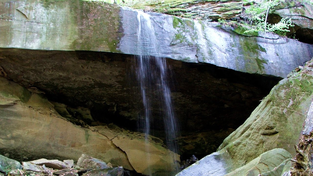
Waterfalls of Velnita stone-quarry - Targu Ocna 10 km away. Starting from the Velnita quarry, an adventurous nature enthusiast, accustomed to wild and rugged terrains, will discover a true waterfall paradise. At the upper part of the quarry, two streams converge.

Saint Anne lake - Ciomat-Puturosu 45.3 km away. Lake Saint Anna is the only well-preserved volcanic crater lake in Eastern Europe. Here are some images from an afternoon outing.

Preachers Rock - Bodoc Mountains 49.2 km away. In the Bodoc Mountains, west-southwest from the Henter peak, we find a rock formation shaped like a mushroom by erosion, called Preacher's Rock. This 2-meter high rock probably got its name from the pagan Hungarian priests, who preached here in the past.

Walking to the top of Sumuleul Mare - Sumuleu Ciuc 50.2 km away. This was my first attempt at shooting a video.

Other places

Stone Mushrooms Beli Plast The Stone Mushrooms (Kamenni Gabi) nature reserve in Bulgaria is situated east of the village of Beli Plast, along the road that connects Kardzhali to Haskovo. Spanning an area of 3 hectares, the reserve is home to several mushroom-shaped rock formations.
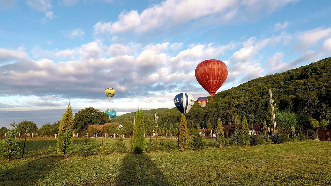
Hot Air Balloon Parade 2018 Campu Cetatii 122.1 km away. This year, the hot air balloons flew low over Campu Cetatii. The weather did not really favor the parade.
Fox Ears Beach Sinemorets 481.8 km away. Fox Ears Beach (Plazh Lisichi ushi) - Sinemorets.

Acapulcos spur via ferrata 309.4 km away. Acapulco's spur (Pintenul lui Acapulco) via ferrata (B/C) - Montana Land, Suncuius.

Fairy Cliff via ferrata route Vadu Crisului 312.6 km away. Fairy Cliff (Peretele Zanelor) via ferrata route - Vadu Crisului. In Vadu Crisului, in the Padurea Craiului Mountains, on the right bank of the Crisul Repede, you can find the newest, in chronological order (2015) the fifth Transylvanian, new type of via ferrata route.

Corcoaia Gorge Gorj county 316.6 km away. The Corcoaia Gorge is one of the most beautiful tourist attractions in the Cerna Valley. It can be reached by car, 43 km away from Baile Herculane, of which about 17 km is on a dusty gravel road.
Agnes Waterfall Western Mecsek The Agnes Waterfall is the largest waterfall in the Mecsek region, although the stream's water only cascades down from a height of one and a half to two meters, over a travertine ledge. Nearby attractions include the Meleg-mány Waterfall and the Mánfa Stone-Cave.
Lookout platform Kis-Tubes Western Mecsek The lookout platform at Kis-Tubes, located at an altitude of 577 meters, was built in 1959, and offers a magnificent panorama of Pécs at the foot of the hills. The concrete lookout, situated on the western side of the Kis-Tubes peak along the ridge connecting Misina to Tubes, was designed by Tibor Kiss.

[ Top ↑ ]
Copyright © 2003-2026 Trekkingklub and friends. Reproduction of any text, picture or video from this website, either in printed or electronic form, is prohibited without prior written permission. Website made with love  in Miercurea Ciuc.