Tourist attractions near Rusesti (Bulzestii de Sus, Hunedoara county, Romania)
Photos of nearby places


Goats Ledge - Trascau Mountains (10 photos) 52.9 km away. Goats Ledge (Brana Caprei, Kecskék párkánya) - Trascau Mountains .

Dark Blue Bruises of the Ponor - Trascau Mountains (16 photos) 53.1 km away. The Dark Blue Bruises of the Ponor (Vanatarile Ponorului) is a polje-type protected area. Polje is a Slovenian word meaning plain, and it refers to a surface karst form.

Dark Blue Bruises of the Ponor, Bedeleu (24 photos) 54 km away. Dark Blue Bruises of the Ponor (Vanatarile Ponorului), Bedeleu - Trascau Mountains.

Balcony Clearing - Trascau Mountains (6 photos) 54.2 km away. Balcony Clearing (Erkély-tisztás, Balconul Sipotelor) - Trascau Mountains.


Stone of Cetea, Horse Pit - Trascau (16 photos) 55.2 km away. Stone of Cetea, Horse Pit (The pit cave from the Stone of Cetea) - Trascau Mountains.

Goat Stone - Craiva, Trascau Mountains (18 photos) 56.1 km away. Goat Stone (Piatra Craivii, Piatra Craivei, Apulon) - Craiva, Trascau Mountains.

Valley of Hell - Padurea Craiului Mountains (23 photos) 57.4 km away. Valley of Hell (Valea Iadului) - Padurea Craiului Mountains.

Kings Cave - Padurea Craiului Mountains (48 photos) 61.7 km away. Craiului (Kings) Cave - Padurea Craiului Mountains.

Fern Cave - Padurea Craiului Mountains (9 photos) 62.4 km away. Ferigi (Fern) Cave - Padurea Craiului Mountains.

Szekler Stone North - Trascau Mountains (8 photos) 64.2 km away. Szekler Stone North (Piatra Secuilor Nord) - Trascau Mountains.

Szekler Stone - Trascau Mountains (42 photos) 64.2 km away. Szekler Stone (Székely-kő, Piatra Secuilor) - Trascau Mountains.

Sohodol pit cave - Padurea Craiului Mountains (10 photos) 66 km away. Sohodol pit cave (Avenul Sohodol) - Padurea Craiului Mountains.

Oxen Waterfall - Padurea Craiului Mountains (12 photos) 66.3 km away. Oxen Waterfall (Cascada Boilor) - Padurea Craiului Mountains.

Moanei Cave - Padurea Craiului Mountains (58 photos) 67.3 km away. The Moanei Cave (Pestera Moanei) is located on the upper course of the Misid River, on the right side of the Misid Gorge (Cheilor Misidului). The cave has two entrances, one fossil and sloped, while a subterranean stream flows through the active gallery.

Napistileu cave - Padurea Craiului (10 photos) 70.7 km away. Napistileu (Ungurul Mic) cave - Padurea Craiului Mountains.
[ Top ↑ ]
Videos of nearby places

Pisoaia waterfall - Vidra 9.4 km away. Pisoaia waterfall (Pisoaia Vidrii, Urine of the otter) - Nemesi, Vidra.

Black Rocks iron path - Bihor Mountains 24.7 km away. Black Rocks is located in the Bihor Mountains, near the Vartop Saddle, to the west of it. It is interesting that the locals (if I understood correctly) do not know this name, but use the name Piatra Buna (meaning Good Stone) for this spectacular rock.


Other places
Belintash Ridge of Dobrostan, Rhodope Mountains Belintash is a mysterious monolithic complex located approximately 50 km from Plovdiv, passing through the scenic Rhodope Mountains. It is situated southeast of the village of Vrata and west of the village of Sini Vruh.

Stone Forest Slanchevo The Stone Forest (Stones stuck in the ground, Pobiti Kamani) of Bulgaria is located 18 km west of Varna, at the foothills of the Eastern Balkan Mountains. Its Bulgarian name, Pobiti Kamani, translates to planted stones, and it is referred to in English as the Stone Desert or Stone Forest.

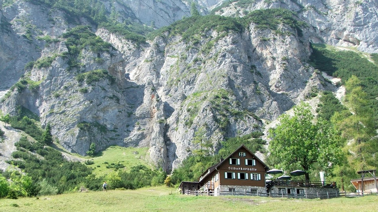
Hias via ferrata Silberkarklamm, Ramsau am Dachstein The Hias via ferrata in the Silberkar Gorge (Silberkarklamm) is the first of the three via ferrata routes, and perhaps the easiest to complete. Two cable bridges and a few trickier sections make it interesting, but it is truly impressive due to the view of the narrow gorge.
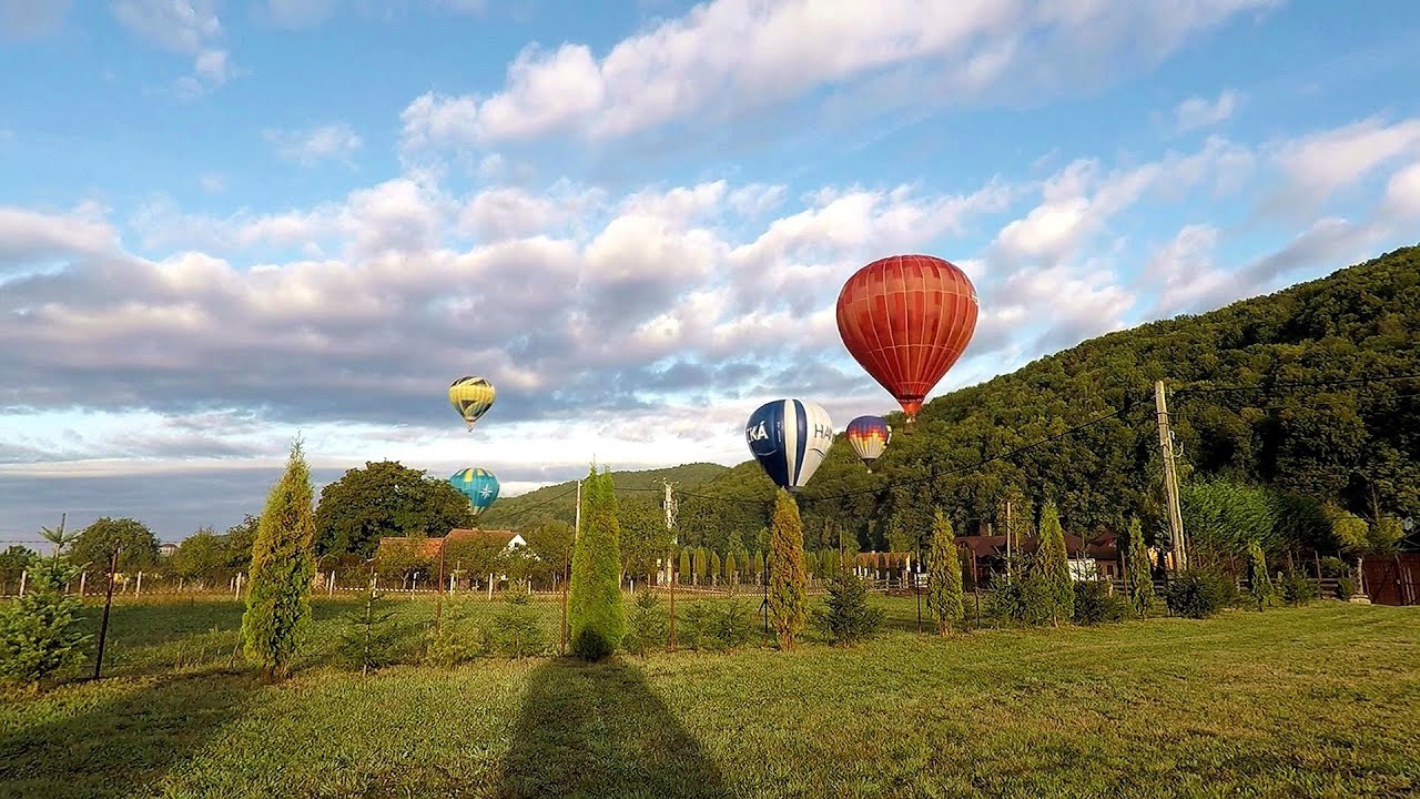
Hot Air Balloon Parade 2018 Campu Cetatii 175.2 km away. This year, the hot air balloons flew low over Campu Cetatii. The weather did not really favor the parade.
Doabra Stones Brezoi, Lotru Mountains 156.5 km away. The DN7A road branches off west from the Olt Valley, from the main road between Sibiu and Ramnicu Valcea, leading towards Voineasa and Lake Vidra. The first settlement is a small town, Brezoi, which is located at the confluence of the Lotru and Olt rivers.
Canyon of Waterfalls Smolyan The eco-trail known as the Canyon of Waterfalls is located in Bulgaria, within the Rhodope Mountains and the Soskovcheto Nature Reserve. It begins at the edge of the Sredoka suburb of the city of Smolyan.
Siega via ferrata Silberkar Gorge, Ramsau am Dachstein The Siega via ferrata, categorized as a C/D level of difficulty, is perhaps the least interesting of the three via ferrata routes in the Silberkar Gorge (Silberkarklamm). This doesn't mean that it's not good, just that the other two are even better.
Turcinovac via ferrata and cave Ovcar Banja 335.6 km away. Difficulty level B, total length: 60 m, height difference: 45 m, year of construction: 2010. Climbing the via ferrata is only permitted with the approval of the Extreme Sports Club Armadillo from Cacak, and there is a fee for it.
[ Top ↑ ]
Copyright © 2003-2026 Trekkingklub and friends. Reproduction of any text, picture or video from this website, either in printed or electronic form, is prohibited without prior written permission. Website made with love  in Miercurea Ciuc.