Tourist attractions near Danceu (Jiana, Mehedinti county, Romania)
Photos of nearby places


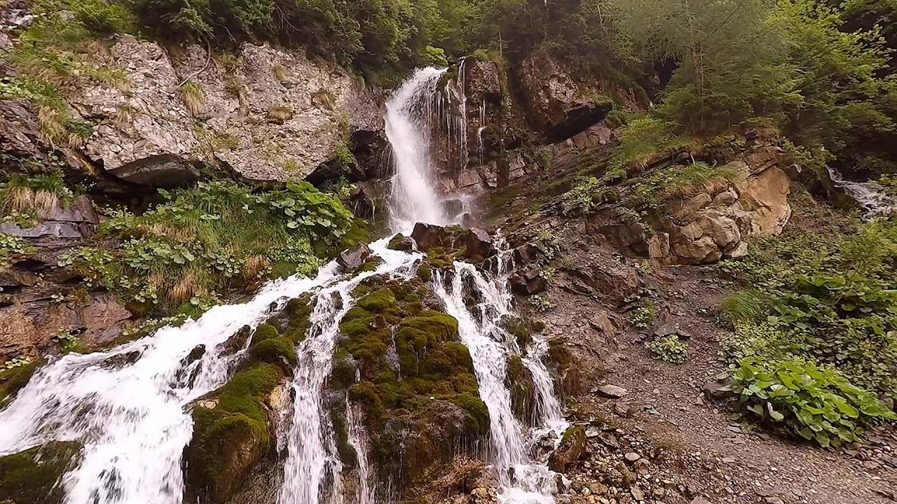
Beusnita waterfall (8 photos) 96.4 km away. Cascada Beusnita, located in the Caras-Severin county, is one of the most impressive waterfalls in the Anina Mountains. The water falling from a height of approximately 15 m, into a clearing in the middle of the forest, creates a uniquely picturesque landscape.

Womens Cave - Parang Mountains (11 photos) 123 km away. The Cave of Women (Pestera Muierii, Pestera Muierilor) is located at the southern foot of the Parang Mountains, in the area of Baia de Fier in Gorj County. There are several climbing routes established on the rocks above the cave and on the other side of the road.

Parangul Mare peak (16 photos) 126.2 km away. Chamois saddle (Saua Caprelor), Carja mountain shelter (Refugiul Carja) - Carja peak (Varful Carja) - Stoienita peak (Varful Stoienita) - Gemanarea - Parangul Mare peak.

Natural bridge next to the Banita Stone Quarry (12 photos) 127.7 km away. Although the Banita Stone Bridge is not far from the road that passes through the village, it is located beyond the railway line, so its approach is a bit cumbersome. We can go around the railway line on Carierei Street, and then we have to walk a few meters from the stone quarry.

Banita Gorge - Banita (16 photos) 129.4 km away. The approximately 250 m long gorge, similar to the Corcoaia Gorge, is truly spectacular. According to assumptions, it was formed by the collapse of a cave passage ceiling, and then the erosion formed spectacular karst formations in the limestone.

Boli Cave - Banita (20 photos) 129.9 km away. The main cave passage is approximately 460 m long, with an entrance portal that is 10 m high and 20 m wide at its base. In the 1960s, bridges were built over the underground stream flowing through the cave.

Ledge path of the chamois - Cheii Gorge (40 photos) 149.7 km away. Ledge path of the chamois (Brana Caprelor) - Cheii Gorge (Cheile Cheii).

Doabra Snail Shells - Brezoi (12 photos) 162.8 km away. Doabra Valley - Calinesti-Brezoi forest - Lotru Valley, Cozia National Park

Circular hiking tour in Cozia Mountain (48 photos) 166 km away. Arutela - Turnu monastery - Rosiei Rocks - Turneanu ridge - Cozia peak - Stone portal - Stanisoara monastery - Gardului waterfall.


Chamois saddle - Fagaras Mountains (12 photos) 203.4 km away. Chamois saddle (Saua Caprei) - Fagaras Mountains.

Goat Stone - Craiva, Trascau Mountains (18 photos) 213.8 km away. Goat Stone (Piatra Craivii, Piatra Craivei, Apulon) - Craiva, Trascau Mountains.

Stone of Cetea, Horse Pit - Trascau (16 photos) 219.7 km away. Stone of Cetea, Horse Pit (The pit cave from the Stone of Cetea) - Trascau Mountains.

Goats Ledge - Trascau Mountains (10 photos) 222.6 km away. Goats Ledge (Brana Caprei, Kecskék párkánya) - Trascau Mountains .

Dark Blue Bruises of the Ponor - Trascau Mountains (16 photos) 230.4 km away. The Dark Blue Bruises of the Ponor (Vanatarile Ponorului) is a polje-type protected area. Polje is a Slovenian word meaning plain, and it refers to a surface karst form.

Stanciu rock porch - Piatra Craiului Mountains (18 photos) 232.5 km away. Stancius rock porch (Ceardacul Stanciului) - Piatra Craiului Mountains (King Rock).

Cave of Stanciu - Piatra Craiului Mountains (10 photos) 232.5 km away. Cave of Stanciu (Pestera Stanciului) - Piatra Craiului Mountains (King Rock).

Dark Blue Bruises of the Ponor, Bedeleu (24 photos) 233.3 km away. Dark Blue Bruises of the Ponor (Vanatarile Ponorului), Bedeleu - Trascau Mountains.

Southern ridge - Piatra Craiului Mountains (42 photos) 233.4 km away. Southern ridge - Piatra Craiului Mountains (King Rock).

The shoulder of Piatra Craiului Mountains (36 photos) 233.5 km away. The shoulder of Piatra Craiului Mountains (King Rock's Shoulder).

Deubels path - Piatra Craiului Mountains (36 photos) 234.2 km away. Plaiul Foii - Deubel cavities (La Zaplaz) - Grind saddle. Deubel's path - Piatra Craiului Mountains (King Rock).
[ Top ↑ ]
Videos of nearby places

Mill of the Devils - Tasna Gorge 69 km away. Mill of the Devils (Moara Dracilor) - Tasna Gorge (Cheile Tasnei). The Tasna Gorges are located in the Mehedinti Mountains, approximately 15 km from the resort of Baile Herculane.

The Wooden Ladders - The villages of Scarisoara and Inelet, Cerna valley 73.7 km away. Scarisoara and Inelet are small, isolated villages located in the mountainous region of Banat. They are situated on the right bank of the Cerna River, approximately 19 km away from the Baile Herculane resort.

Blasted Rock hanging path - Cerna Valley 74.2 km away. The Blasted Rock (Piatra Puscata) hanging path is located on the geographical right bank of the Cerna River, near the confluence of the Iuta stream, approximately 20 km from Baile Herculane. In this area, the presence of limestone formations has caused the valley to become narrower.

Rudariei watermills - Eftimie Murgu 74.5 km away. I have visited the twenty-two wooden water mills with horizontal wheels, located in the valley of the Rudaria stream, mostly in the rain and under an umbrella. Some of them are still in use today.

Belogradchik fortress 82.4 km away. Belogradchik is located in the northwestern part of Bulgaria, in the Vidin Province, at the foot of the Balkan Mountains, near the Serbian border. Its name means little white town.
Other places
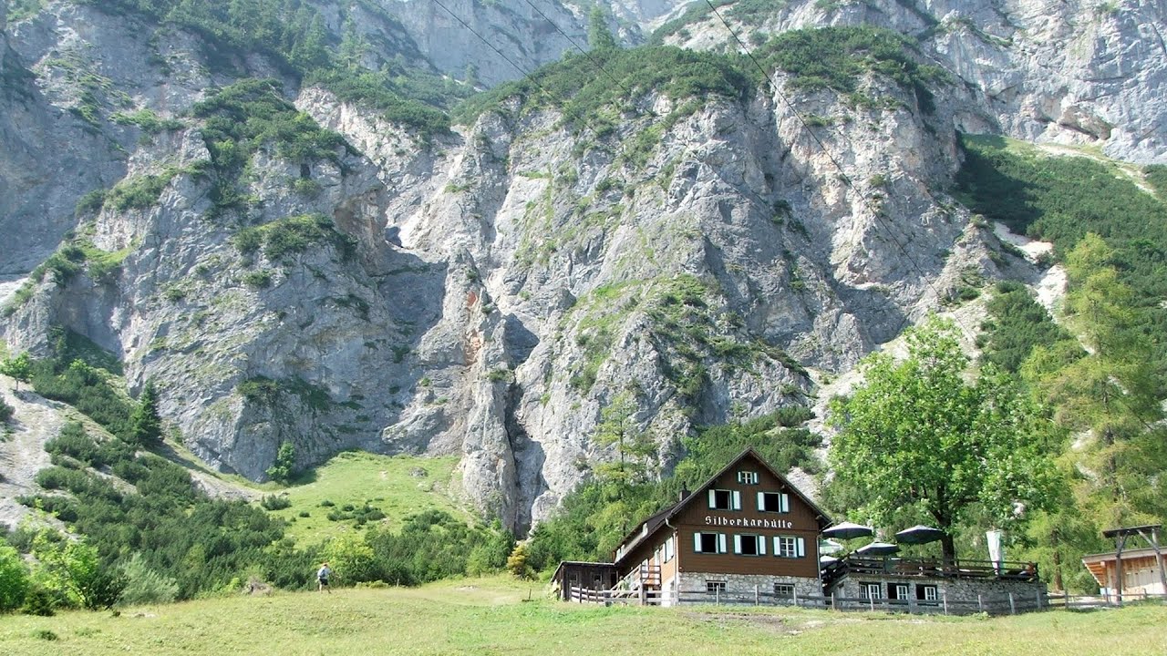
Siega via ferrata Silberkar Gorge, Ramsau am Dachstein The Siega via ferrata, categorized as a C/D level of difficulty, is perhaps the least interesting of the three via ferrata routes in the Silberkar Gorge (Silberkarklamm). This doesn't mean that it's not good, just that the other two are even better.

Waterfalls of Velnita stone-quarry Targu Ocna 367.5 km away. Starting from the Velnita quarry, an adventurous nature enthusiast, accustomed to wild and rugged terrains, will discover a true waterfall paradise. At the upper part of the quarry, two streams converge.
Waterfalls of Lapos creek Bicaz Gorge 363.2 km away. One of the lesser-known attractions of the Bicaz Gorges is the series of waterfalls along Lapos Creek. This creek flows between Cupas Stone and Bardos Stone before eventually merging with Bicaz Creek, forming spectacular waterfalls beneath the Altar Stone.
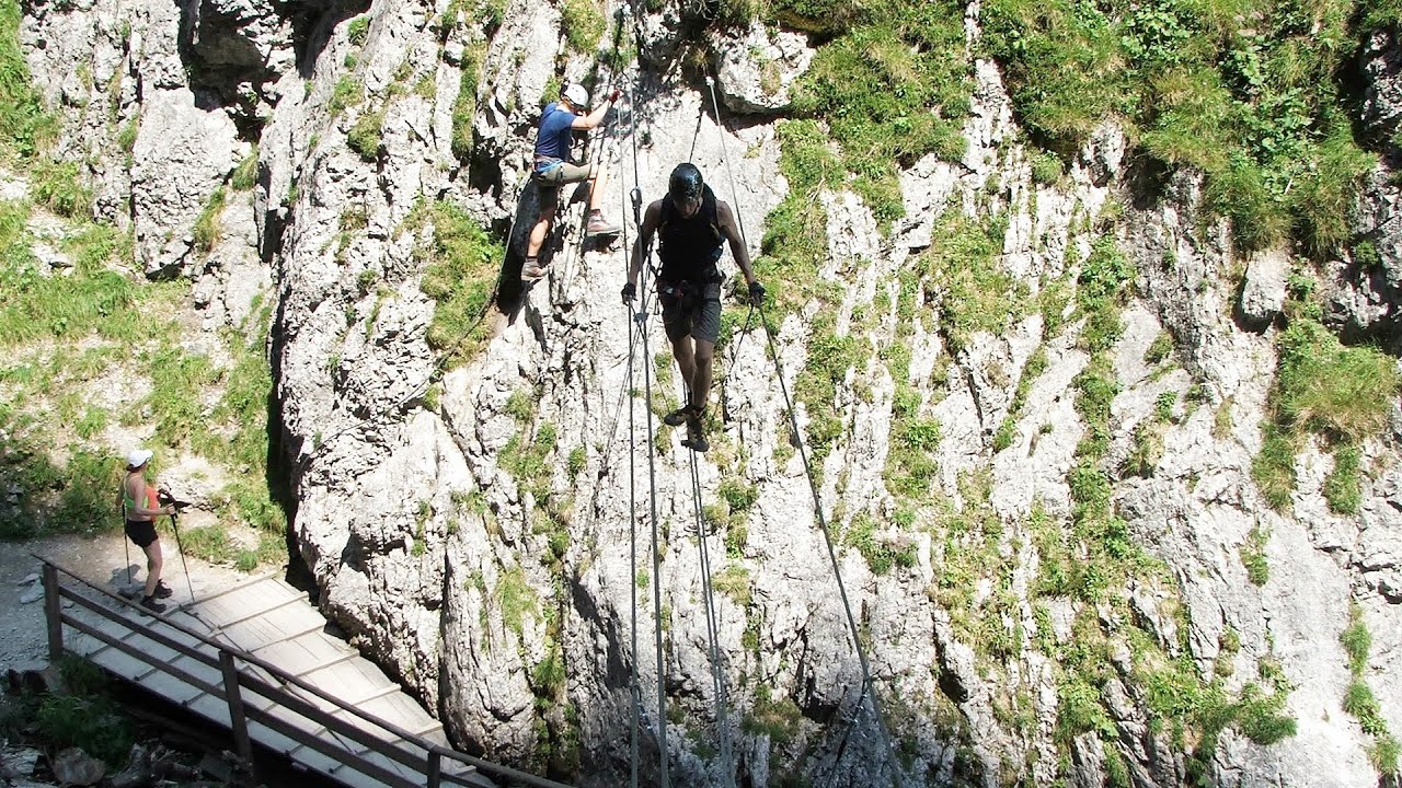
Rosina via ferrata Silberkar Gorge, Ramsau am Dachstein The Rosina via ferrata is the most difficult via ferrata in the Silberkar Gorge (Silberkarklamm), has a D difficulty rating, and it is a vertical masterpiece. After a short suspension bridge above the stream, it leads up the rock wall next to the gorge waterfall, all the way vertically.

Fairy Cliff via ferrata route Vadu Crisului 290.2 km away. Fairy Cliff (Peretele Zanelor) via ferrata route - Vadu Crisului. In Vadu Crisului, in the Padurea Craiului Mountains, on the right bank of the Crisul Repede, you can find the newest, in chronological order (2015) the fifth Transylvanian, new type of via ferrata route.

Shipka pass Shipka 276 km away. The Shipka Pass is one of the most spectacular crossings of the Balkan Mountains, and is part of the Bulgarka Nature Park. It separates the provinces of Gabrovo and Stara Zagora, and provides a connection between the cities of Gabrovo and Kazanlak.

Ski resort Poiana Brasov Postavarul Mountains 260.2 km away. Shining sun and an Austria-feeling on the impeccable slopes of the ski paradise Poiana Brasov above Brasov. Sunbathing, coffee and refreshing drinks on the terrace of Julius Römer chalet.
Foamy valley waterfall Bucegi Mountains 248.5 km away. Access to the Foamy valley waterfall (Cascada Valea Spumoasa) is made from the town of Busteni. The starting point is the lower station of the cable car that ascends to the Babele cabin.
Other destinations
Gornjak via ferrata and Kudelinovs fortress Zdrelo 95.6 km away. Difficulty level C/D, total length: 400 m, height difference: 330 m, year of construction: 2019, total length of the route to Kudelinov's fortress: 1100 m. Access to the via ferrata is free.
Lipovac via ferrata and monastery of Saint Stephen 113.8 km away. Difficulty level B, total length: 190 m, height difference: 90 m, year of construction: 2022. It is necessary to contact the PSK Brđanka club to obtain the key for the ladders at the entrance of the via ferrata.
Natural stone bridge Aglen 182.4 km away. Natural stone arch on the Vit river, near the village of Aglen. Crocodile shaped rock, Elephant rock.
[ Top ↑ ]
Copyright © 2003-2026 Trekkingklub and friends. Reproduction of any text, picture or video from this website, either in printed or electronic form, is prohibited without prior written permission. Website made with love  in Miercurea Ciuc.