Tourist attractions near Racova (Ilovat, Mehedinti county, Romania)
Photos of nearby places


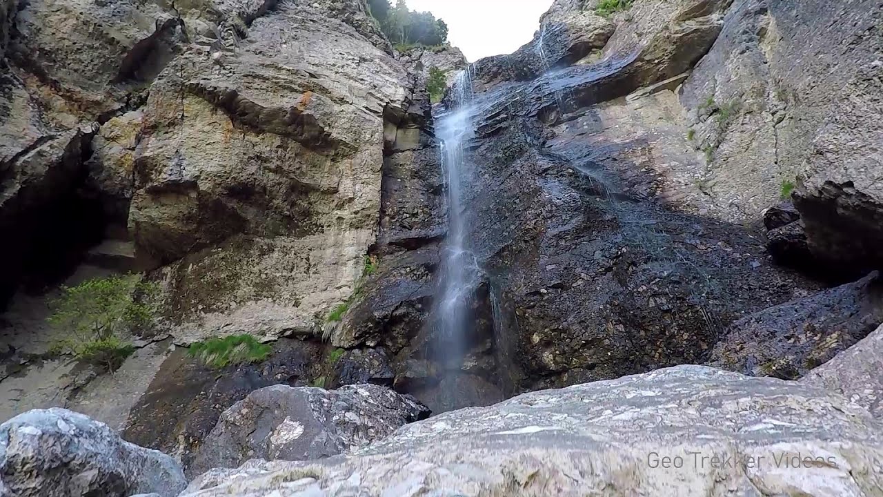
Beusnita waterfall (8 photos) 77.5 km away. Cascada Beusnita, located in the Caras-Severin county, is one of the most impressive waterfalls in the Anina Mountains. The water falling from a height of approximately 15 m, into a clearing in the middle of the forest, creates a uniquely picturesque landscape.

Natural bridge next to the Banita Stone Quarry (12 photos) 82 km away. Although the Banita Stone Bridge is not far from the road that passes through the village, it is located beyond the railway line, so its approach is a bit cumbersome. We can go around the railway line on Carierei Street, and then we have to walk a few meters from the stone quarry.

Banita Gorge - Banita (16 photos) 84.2 km away. The approximately 250 m long gorge, similar to the Corcoaia Gorge, is truly spectacular. According to assumptions, it was formed by the collapse of a cave passage ceiling, and then the erosion formed spectacular karst formations in the limestone.

Boli Cave - Banita (20 photos) 84.8 km away. The main cave passage is approximately 460 m long, with an entrance portal that is 10 m high and 20 m wide at its base. In the 1960s, bridges were built over the underground stream flowing through the cave.

Parangul Mare peak (16 photos) 85.6 km away. Chamois saddle (Saua Caprelor), Carja mountain shelter (Refugiul Carja) - Carja peak (Varful Carja) - Stoienita peak (Varful Stoienita) - Gemanarea - Parangul Mare peak.

Womens Cave - Parang Mountains (11 photos) 89.1 km away. The Cave of Women (Pestera Muierii, Pestera Muierilor) is located at the southern foot of the Parang Mountains, in the area of Baia de Fier in Gorj County. There are several climbing routes established on the rocks above the cave and on the other side of the road.

Ledge path of the chamois - Cheii Gorge (40 photos) 118.9 km away. Ledge path of the chamois (Brana Caprelor) - Cheii Gorge (Cheile Cheii).

Doabra Snail Shells - Brezoi (12 photos) 131.4 km away. Doabra Valley - Calinesti-Brezoi forest - Lotru Valley, Cozia National Park

Circular hiking tour in Cozia Mountain (48 photos) 136.3 km away. Arutela - Turnu monastery - Rosiei Rocks - Turneanu ridge - Cozia peak - Stone portal - Stanisoara monastery - Gardului waterfall.

Goat Stone - Craiva, Trascau Mountains (18 photos) 166.8 km away. Goat Stone (Piatra Craivii, Piatra Craivei, Apulon) - Craiva, Trascau Mountains.

Chamois saddle - Fagaras Mountains (12 photos) 170.9 km away. Chamois saddle (Saua Caprei) - Fagaras Mountains.

Stone of Cetea, Horse Pit - Trascau (16 photos) 172.6 km away. Stone of Cetea, Horse Pit (The pit cave from the Stone of Cetea) - Trascau Mountains.

Goats Ledge - Trascau Mountains (10 photos) 175.4 km away. Goats Ledge (Brana Caprei, Kecskék párkánya) - Trascau Mountains .

Dark Blue Bruises of the Ponor - Trascau Mountains (16 photos) 183 km away. The Dark Blue Bruises of the Ponor (Vanatarile Ponorului) is a polje-type protected area. Polje is a Slovenian word meaning plain, and it refers to a surface karst form.

Dark Blue Bruises of the Ponor, Bedeleu (24 photos) 185.9 km away. Dark Blue Bruises of the Ponor (Vanatarile Ponorului), Bedeleu - Trascau Mountains.


Balcony Clearing - Trascau Mountains (6 photos) 186.9 km away. Balcony Clearing (Erkély-tisztás, Balconul Sipotelor) - Trascau Mountains.

Aries valley - Trascau Mountains (10 photos) 187.9 km away. Aries (Golden) valley - Trascau Mountains.


Szekler Stone North - Trascau Mountains (8 photos) 194.2 km away. Szekler Stone North (Piatra Secuilor Nord) - Trascau Mountains.

Szekler Stone - Trascau Mountains (42 photos) 194.2 km away. Szekler Stone (Székely-kő, Piatra Secuilor) - Trascau Mountains.
[ Top ↑ ]
Videos of nearby places

Mill of the Devils - Tasna Gorge 27.6 km away. Mill of the Devils (Moara Dracilor) - Tasna Gorge (Cheile Tasnei). The Tasna Gorges are located in the Mehedinti Mountains, approximately 15 km from the resort of Baile Herculane.

The Wooden Ladders - The villages of Scarisoara and Inelet, Cerna valley 29.8 km away. Scarisoara and Inelet are small, isolated villages located in the mountainous region of Banat. They are situated on the right bank of the Cerna River, approximately 19 km away from the Baile Herculane resort.

Blasted Rock hanging path - Cerna Valley 29.9 km away. The Blasted Rock (Piatra Puscata) hanging path is located on the geographical right bank of the Cerna River, near the confluence of the Iuta stream, approximately 20 km from Baile Herculane. In this area, the presence of limestone formations has caused the valley to become narrower.

Corcoaia Gorge - Gorj county 37.8 km away. The Corcoaia Gorge is one of the most beautiful tourist attractions in the Cerna Valley. It can be reached by car, 43 km away from Baile Herculane, of which about 17 km is on a dusty gravel road.

Rudariei watermills - Eftimie Murgu 53.2 km away. I have visited the twenty-two wooden water mills with horizontal wheels, located in the valley of the Rudaria stream, mostly in the rain and under an umbrella. Some of them are still in use today.
Other places
Five Fingers, World NATURE Heritage Lookout, World Heritage Spiral, Dachstein Shark The second station of the cable car departing from Obertraun is the Krippenstein peak (2100 m). Here you can find the famous Five Fingers (5fingers) lookout, which offers a unique view of Hallstatt and Obertraun below, as well as the Hallstättersee lake.


Stone Forest Slanchevo 431.6 km away. The Stone Forest (Stones stuck in the ground, Pobiti Kamani) of Bulgaria is located 18 km west of Varna, at the foothills of the Eastern Balkan Mountains. Its Bulgarian name, Pobiti Kamani, translates to planted stones, and it is referred to in English as the Stone Desert or Stone Forest.
Eagles Eye Yagodina 373.1 km away. Orlovo Oko (Eagle's Eye) is a lookout viewpoint located in the Rhodope Mountains, near the peak of Saint Ilia and close to the village of Yagodina, Bulgaria. The steel structure, built at an altitude of 1,563 meters, rises 670 meters above the spectacular Buynovsko Gorge, along with the winding river and road that traverse it.
Wild Ferenc memorial path Suhardul Mic 323.3 km away. In recent days, this news has been everywhere: the via ferrata route built on the southwest wall of Suhardul Mic (Little Suhard) has finally been completed and inaugurated. The new route has been named after Ferenc Wild, in memory of the former mountain rescuer, sports writer, and one of the founders of the mountain rescue association in Gheorgheni.

Kossuth Rock Harghita Bath 286 km away. Kossuth Rock - Harghita Bath (Harghita-Bai), Harghita Mountains.
Arched stone bridge Rugova Canyon 314 km away. Arched stone bridge - Rugova Canyon (Gryka e Rugoves).

Dino Parc Rasnov 229.7 km away. On June 12, 2015, one of the largest dinosaur theme parks in the region opened in Rasnov, where we can see 45 life-sized dinosaurs. The facility is located directly next to the Rasnov Fortress, which is one of the best-preserved Transylvanian Saxon peasant fortresses.
Upstream of the Izvorul Dorului creek Vanturis waterfalls 221.4 km away. Upstream of the Izvorul Dorului (Source of longing) creek - Vanturis waterfalls, Bucegi Mountains.
Other destinations
Gornjak via ferrata and Kudelinovs fortress Zdrelo 114.3 km away. Difficulty level C/D, total length: 400 m, height difference: 330 m, year of construction: 2019, total length of the route to Kudelinov's fortress: 1100 m. Access to the via ferrata is free.
Lipovac via ferrata and monastery of Saint Stephen 156.1 km away. Difficulty level B, total length: 190 m, height difference: 90 m, year of construction: 2022. It is necessary to contact the PSK Brđanka club to obtain the key for the ladders at the entrance of the via ferrata.
[ Top ↑ ]
Copyright © 2003-2026 Trekkingklub and friends. Reproduction of any text, picture or video from this website, either in printed or electronic form, is prohibited without prior written permission. Website made with love  in Miercurea Ciuc.