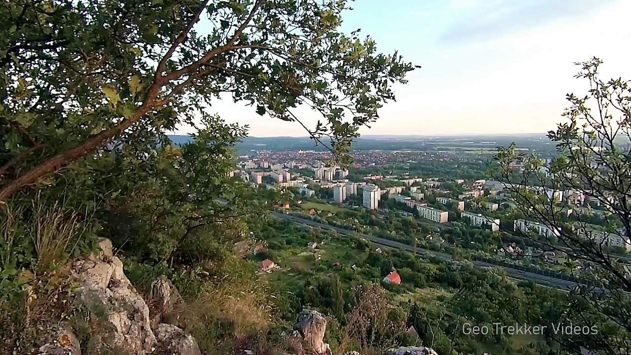
Jacob Hill Lookout - Western Mecsek
Jacob Hill is a popular hiking destination in Western Mecsek, with an elevation of 592 m. At the top, there are the ruins of a Pauline monastery and a lookout tower. Nearby attractions include the Éger Valley, Éger Peak, the Babás rock formations, the Jubilee Cross, Zsongor Stone, and the Wolf Spring.
Login (register) for the full descriptions, and access to the photos and videos.
Airport nearby: Pécs-Pogány Airport (PEV - Pécs, Hu), 14 km away.
Photos of nearby places

Slunjcica - Rastoke, Slunj - Croatia (12 photos) 226.5 km away. The Slunjcica river is situated in central Croatia, flowing through the Kordun region. The city of Slunj is named after this river.

Plitvice Lakes - Croatia (60 photos) 237.9 km away. The Plitvice Lakes National Park is the oldest and largest national park in Croatia. It is located in a mountainous region between Mala Kapela and Licka Pljesivica.

Mariazell climbing route, Felixs Celestial Ladder, Devils Bridge - Climbing Park Spielmäuer (60 photos) 278.1 km away. Climbing Park Spielmäuer - Mariazell climbing route, Felix's Celestial Ladder, Devil's Bridge (Kletterpark Spielmäuer - Mariazeller Steig, Felix Himmelsleiter, Teufelsbrücke) - Wegscheid, Austria.

The Devils Bridge - Wegscheid, Austria (18 photos) 278.9 km away. The Devil's Bridge, Teufelsbrücke in German, is located just ten kilometers from the city of Mariazell, near the Klettersteigpark Spielmäuer via ferrata park. From the top of the via ferrata park, it is worth taking a detour to the Devil's Bridge, which is located near the starting point of the descent path.

Manita pec cave - Croatia (21 photos) 287.9 km away. There are 115 caves so far known in the Paklenica National Park, Manita pec is the most famous one, and is open to the public for guided visits. The cave has beautiful chambers, and various cave formations such as stalagmites, stalactites, columns, and flowstones.

Paklenica National Park - Croatia (55 photos) 290.4 km away. In 1949, the area of Velika and Mala Paklenica was designated as a national park due to its natural features, forests, and geomorphologic structures. The main purpose was to protect the largest and best-preserved forest complex in Dalmatia, which was at risk from excessive exploitation.

Port of Jablanac - Croatia (18 photos) 296.7 km away. Situated in Lika-Senj county, Croatia, Jablanac is a village located beneath the Velebit mountain, overlooking the neighboring island of Rab in the Adriatic Sea. In close proximity to Jablanac are the Velebit mountain and the Northern Velebit National Park.

Old town Krk - Krk Island, Croatia (11 photos) 302 km away. Krk is a Croatian island located in the Adriatic Sea. It is the largest island in the country, and has a rich history dating back to ancient times.

Rab Island - Croatia (24 photos) 303 km away. Rab is a small island located in the Adriatic Sea, belonging to Croatia. It is known for its beautiful beaches, mild climate, and historic town of the same name.

Postojna Cave - Slovenia (12 photos) 306.6 km away. The Postojna Cave (Postojnska jama) is a renowned tourist attraction located in Slovenia. It is a network of underground galleries and halls, stretching over 24 kilometers, known for its geological formations, including stalagmites and stalactites.


[ Top ↑ ]
Videos of nearby places
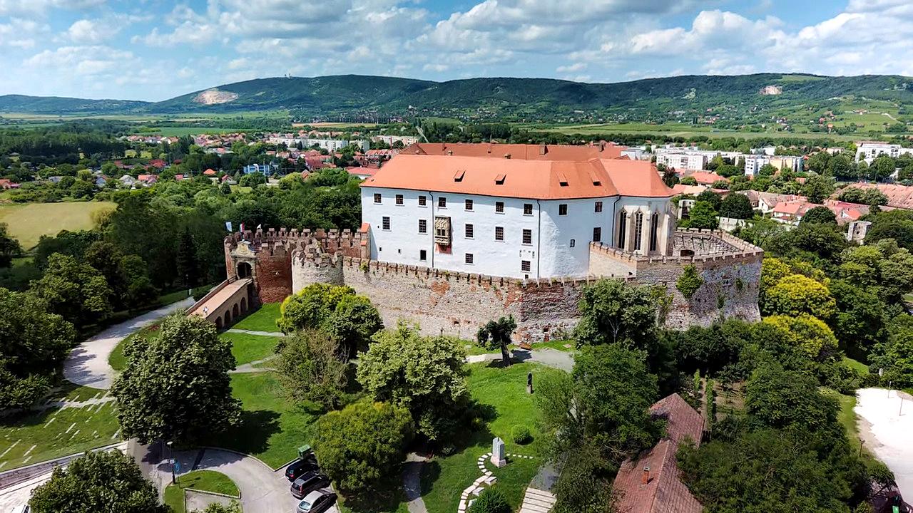
Siklós castle 29.4 km away. The Siklós Castle is an important historical landmark in Hungary. Its fortress walls were laid around 1260, with the first written record dating back to 1294.
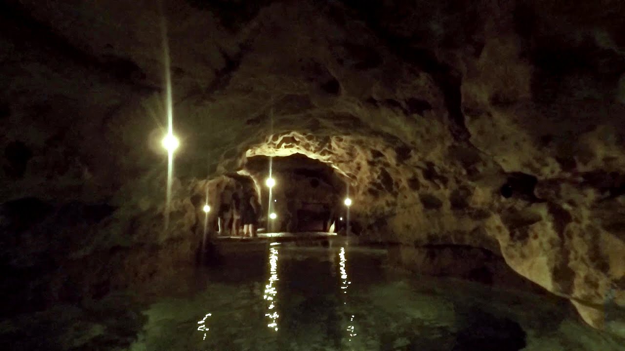
Tapolca lake cave - Balaton-felvidéki National Park 102.8 km away. The Tapolca lake cave is situated in the Balaton-felvidéki National Park. A modern visitor center has been constructed at its entrance, featuring ten rooms that highlight the unique characteristics of karst regions.
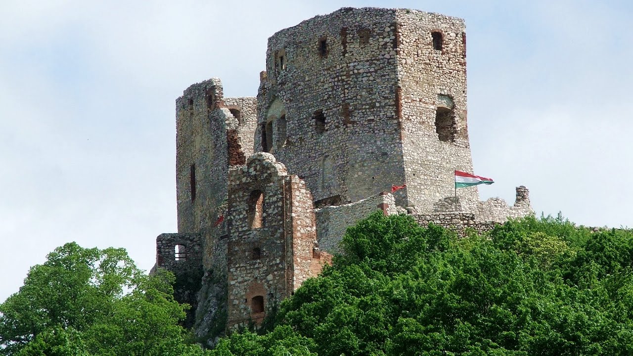
Castle panorama route, Zoltán Tálos memorial route, Besiegers route - Csesznek 141.2 km away. Castle panorama route (D), Zoltán Tálos memorial route (E), Besieger's route (C), Kőmosó-ravine, Csesznek, Veszprém county, Hungary. The via ferratas in Csesznek are suitable for both getting acquainted with climbing, and assessing our capabilities.
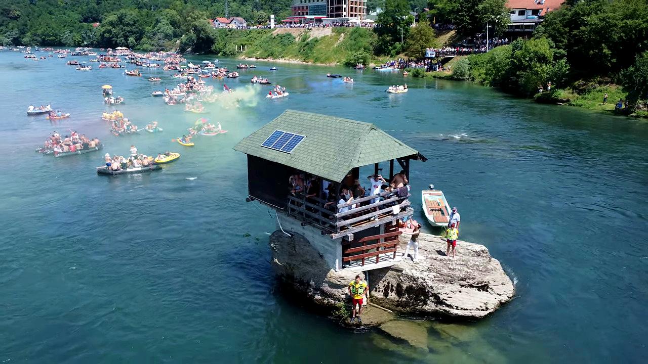
Drina river house - Bajina Bašta 259.9 km away. The house visible on the Drina River (Kućica na Drini) is a unique wooden structure built on a rock in the middle of the river, near Bajina Bašta, Serbia. The house is located on the border between Serbia and Bosnia-Herzegovina, close to the border line between the two countries.
Other places
Drina river house Bajina Bašta 259.9 km away. The house visible on the Drina River (Kućica na Drini) is a unique wooden structure built on a rock in the middle of the river, near Bajina Bašta, Serbia. The house is located on the border between Serbia and Bosnia-Herzegovina, close to the border line between the two countries.
Giant Ice Cave Dachstein Salzkammergut, Obertraun am Hallstättersee 372.8 km away. The second cave accessible to the public at the Schönbergalm above Obertraun on Lake Hallstatt is the Giant Ice Cave (Rieseneishöhle). For me, it was more spectacular than the Mammoth Cave.
Loreley and Pink Panther iron path Baia de Fier 447.6 km away. The Loreley via ferrata (graded B/C, with an elevation difference of approximately 100 m and a length of about 100 m) is located on the rock wall on the opposite side of the road. A branch from its upper section leads to the Pink Panther (Pantera Roz, graded A/B/C, approximately 200 meters long, with an elevation difference of about 50 meters).
Via ferrata Shpellat Peja 416.3 km away.
Banita Gorge and Banita rock bridge 407 km away. They say about this place that only very few people know about it, but that's not true. In fact, most nature lovers have heard of it, seen pictures taken here, even if not everyone has been able to come here.
Via Ferrata Pink Panther Baia de Fier 447.7 km away. In the area of Baia de Fier in Gorj County, several via ferrata routes have been set up on the rock above the Women's Cave (Muierii Cave) and on the other side of the road. At that time (2018), there were a total of seven.
Pisoaia waterfall Vidra 365.3 km away. Pisoaia waterfall (Pisoaia Vidrii, Urine of the otter) - Nemesi, Vidra.
Via Ferrata Fairy Castle Vadu Crisului 348.1 km away. Via Ferrata Fairy Castle (Castelul Zanelor, Casa Zmeului, The House of the Dragon) - Vadu Crisului. South of Vadu Crisului, in the Padurea Craiului Mountains, lies the Vadu Crisului Gorge, a section of the Crisul Repede river that narrows between rocky walls.
Clocota waterfall Geoagiu-Bai, Metaliferi Mountains 388.3 km away.
Crystal Cave at Farcu Mine 337.5 km away. In the Padurea Craiului Mountains, near Rosia, in the Farcu bauxite mine, in 1987, the miners accidentally discovered a cave. It was filled with crystal-shaped limestone formations.
The Gorge of the Creek of the Gorge Buila-Vanturarita National Park 473.7 km away. The Gorges of the Creek of the Gorge (Cheii Gorge, Cheile Cheii) is located in the Buila-Vanturarita National Park within the Capatana Mountains. It is one of the most beautiful and picturesque gorges in Romania.
Boli Cave Banita 407.5 km away. The Boli Cave is located 6 km north of Petrosani, on the road that connects Hateg with the Jiu Valley. Here, the railway line that connects the two parts of Hunedoara County passes through, featuring a total of 66 curves and 8 tunnels.
Rosina via ferrata Silberkar Gorge, Ramsau am Dachstein 368.8 km away. The Rosina via ferrata is the most difficult via ferrata in the Silberkar Gorge (Silberkarklamm), has a D difficulty rating, and it is a vertical masterpiece. After a short suspension bridge above the stream, it leads up the rock wall next to the gorge waterfall, all the way vertically.
Hilis cave Turda Gorge via ferrata 428 km away. While the first time I climbed this via ferrata (Sky Fly) in the morning, now I climbed it in the light of the setting sun. The red-dressed rocks created a special atmosphere, and I could admire the sunset from the top of the climbing route.
Via ferrata Mat Peja 416.7 km away.
Other destinations
Lookout platform Kis-Tubes Western Mecsek 5 km away. The lookout platform at Kis-Tubes, located at an altitude of 577 meters, was built in 1959, and offers a magnificent panorama of Pécs at the foot of the hills. The concrete lookout, situated on the western side of the Kis-Tubes peak along the ridge connecting Misina to Tubes, was designed by Tibor Kiss.
Balázs Hill Lookout Western Mecsek 5.1 km away. The Balázs hill lookout, located at an altitude of 320 meters, offers a beautiful view of Lake Pécs and the wooded mountain ranges of Western Mecsek. The original lookout, built in 1975, was destroyed by fire, and it was rebuilt in 2001 using a metal structure, which was renovated in 2014.
Agnes Waterfall Western Mecsek 7.8 km away. The Agnes Waterfall is the largest waterfall in the Mecsek region, although the stream's water only cascades down from a height of one and a half to two meters, over a travertine ledge. Nearby attractions include the Meleg-mány Waterfall and the Mánfa Stone-Cave.
Óbányai Valley Eastern Mecsek 22.7 km away. The Óbányai Valley is located in the Eastern Mecsek Landscape Protection Area, stretching between Óbánya and Kisújbánya. Its attractions include the Slanting waterfall or Fairy Stairs, and the Dripping Rock.
[ Top ↑ ]
Copyright © 2003-2026 Trekkingklub and friends. Reproduction of any text, picture or video from this website, either in printed or electronic form, is prohibited without prior written permission.
The given distances are to be understood as straight line distances, and are approximate. Website made in Miercurea Ciuc  .
.