Seagulls beach and the Marina Port Sozopol harbour - photos


Page no. 1, photos: 1-2, 2 photos in total.

Marina Port Sozopol offers everything an experienced sailor could wish for. The port has 243 berths for boats up to 25 meters long, equipped with electricity and drinking water.
Copyright © 2025 Trekkingklub.com.
Already published 8925 photos and 174 videos. Please register for full access.
Photos of nearby places

Art Complex Anel Sozopol - Budjaka Peninsula (6 photos) 3.56 km away
Art Complex Anel is located on Bulgaria's Black Sea coast near Sozopol, on the Budjaka Peninsula. It is the world's only hotel-art-museum complex, featuring a natural lagoon and stunning architecture.

Castle of Ravadinovo (In love with the wind) (79 photos) 3.74 km away
The Castle of Ravadinovo, situated near Sozopol in Bulgaria, is a enchanting structure that delights visitors with its fairytale-like appearance and distinctive charm. Also known as In Love with the Wind, this castle is the visionary project of architect Georgi Kostadinov Tumpalov, who dedicated himself to its design and construction from 1996 onward, transforming his dream into reality through perseverance and community support.

Cape Agalina - Sozopol (24 photos) 5.33 km away
Agalina Cape is located on Bulgaria's southern Black Sea coast, south of Sozopol, Smokinya Beach, and Kavacite Beach. Its name, Agalina, comes from the Greek word agalia, which means embrace.

Drivers (Alepu) beach between Duni and Arkutino (6 photos) 7.29 km away
Drivers or Chauffeurs Beach, also known as Alepu Beach or Dunes, is one of the most renowned and scenic wild beaches along the South Black Sea coast. Located between Duni Resort to the north and Cape Humata to the south, the beach stretches nearly 3 kilometers in length and reaches a width of up to 70 meters.

Thracian Fortress Ranuli (Valchan's fortress) and the Lion's Head Rock (40 photos) 12.13 km away
On Copper Ridge (Meden Rid), overlooking the Ropotamo River, the Thracian miner tribe Skirmiani constructed a fortress. During the first and second millennia BC, they arranged large megalithic stones to build walls and structures.


Dragon House dolmen (Zmeyova Kashta) (5 photos) 13.24 km away
The dolmen Zmeyova Kashta (Dragon's House) is located very close to the asphalt road, near the Begliktash parking area, at the beginning of the trail to the Thracian fortress Ranuli. It is a small rectangular structure made of large stone blocks.

[ Top ↑ ]
Videos of nearby places
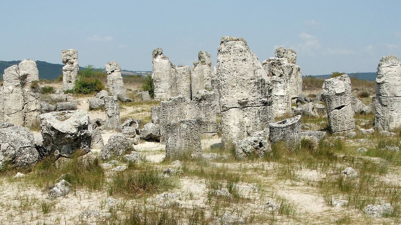
Pobiti Kamani (Stone Forest) - Slanchevo 89.96 km away
The Stone Forest of Bulgaria is located 18 km west of Varna, at the foothills of the Eastern Balkan Mountains. Its Bulgarian name, Pobiti Kamani, translates to planted stones, and it is referred to in English as the Stone Desert or Stone Forest.
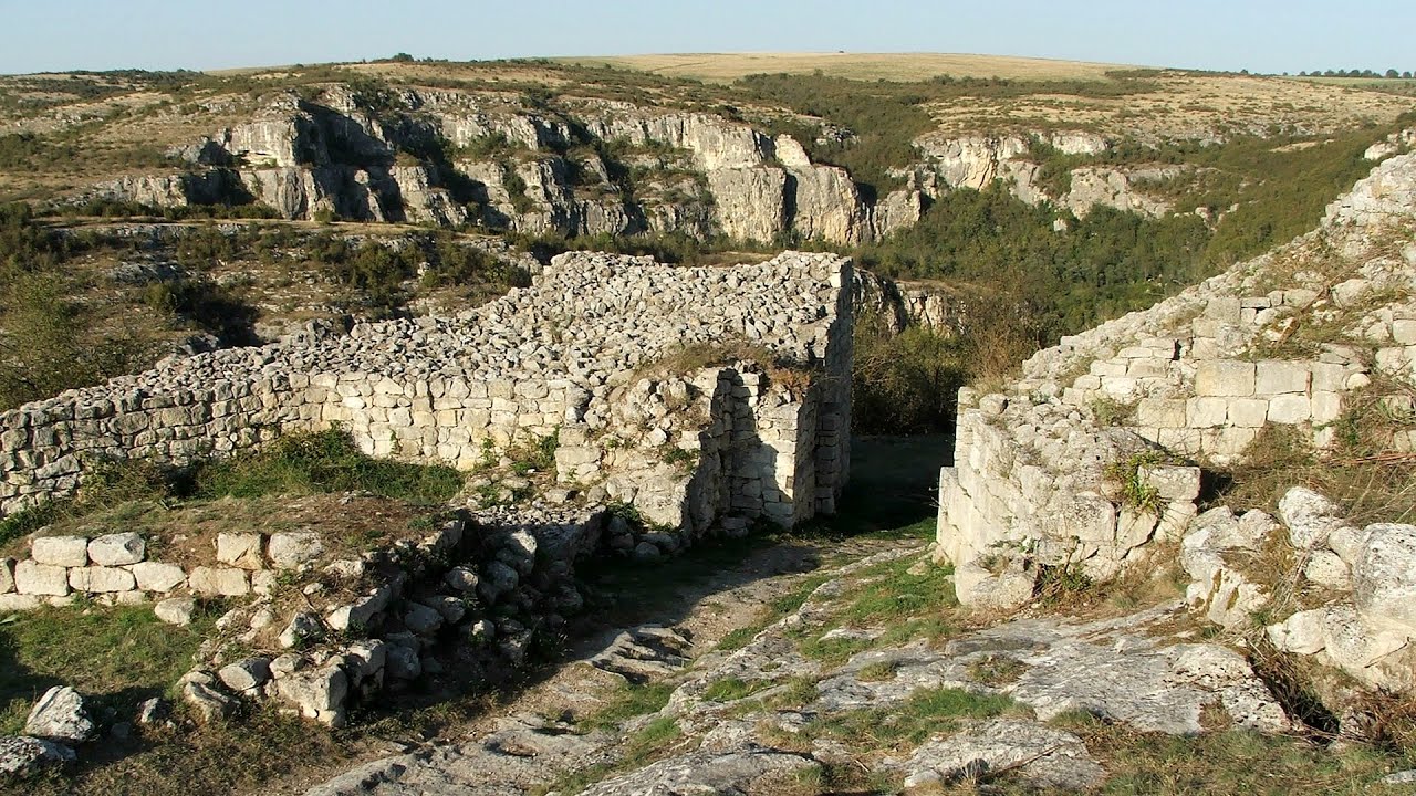
Cherven, a medieval fortified town - Bulgaria 190.49 km away
Located about 30 km south of the city of Ruse in Bulgaria, the Cherven medieval fortress can be found in the Rusenski Lom Nature Park. Originally a Byzantine fortification from the 6th century, it reached the height of its development in the 14th century.

Buzludzha monument - Kazanluk 191.21 km away
Buzludzha is a historically significant mountain located in the Central Balkan Mountains of Bulgaria. At its summit, at an altitude of 1432 meters above sea level, there is an abandoned monument.
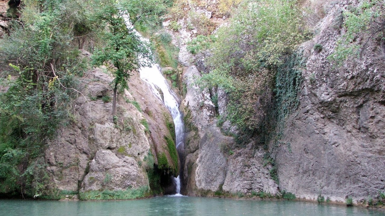
Kaya Bunar (Hotnishki Vodopadi, Hotnitsa Waterfall) - Hotnitsa 195 km away
The Kaya Bunar Waterfall (Hotnishki Vodopadi) is located 20 km from the city of Veliko Tarnovo in Bulgaria. The waterfall is 30 meters high, and there are several smaller cascades above it.
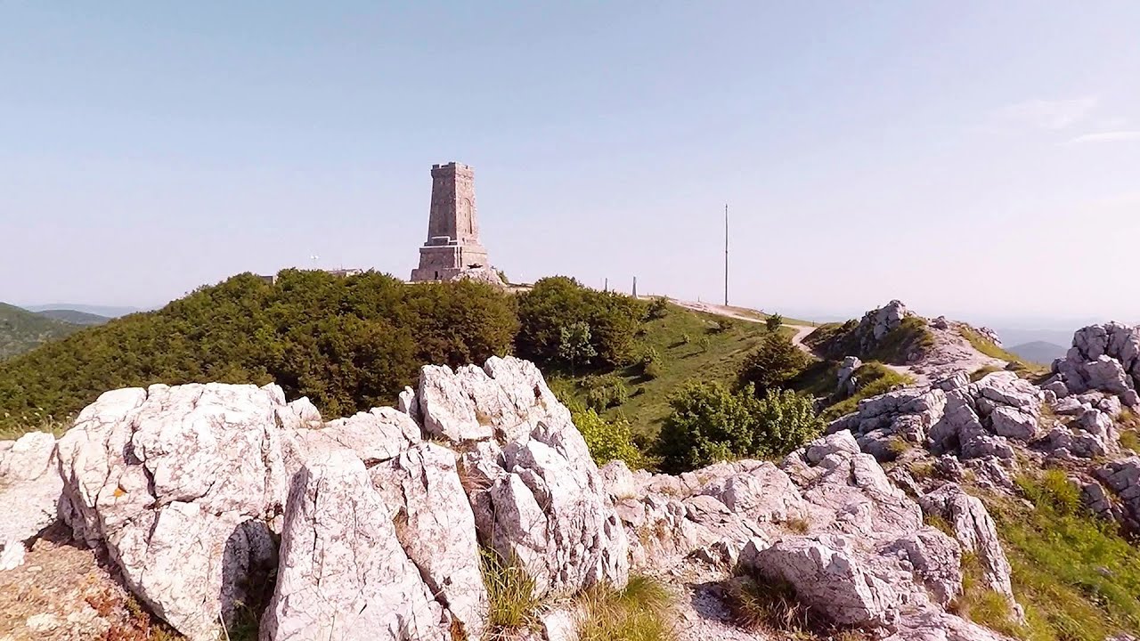
Shipka pass - Shipka 197.29 km away
The Shipka Pass is one of the most spectacular crossings of the Balkan Mountains, and is part of the Bulgarka Nature Park. It separates the provinces of Gabrovo and Stara Zagora, and provides a connection between the cities of Gabrovo and Kazanlak.
Other places
Dyavolski Most (Devil's Bridge) Ardino 230.54 km away
The Devil's Bridge (Dyavolski Most, in Turkish Sheytan Kyupriya) is located in the gorge of the Arda River, just north of the town of Ardino in Bulgaria. It was constructed in the early 16th century, between 1515 and 1518, by an architect named Dimitar, on the remains of an earlier Roman bridge.
The Devil's Bridge (Dyavolski Most, in Turkish Sheytan Kyupriya) is located in the gorge of the Arda River, just north of the town of Ardino in Bulgaria. It was constructed in the early 16th century, between 1515 and 1518, by an architect named Dimitar, on the remains of an earlier Roman bridge.
Skaklya waterfall Vratsa 348.17 km away
The largest seasonal waterfall in Bulgaria plunges down from a height of 141 meters. It is located in the Vratsa Mountain National Park, just one and a half kilometers away from the city of Vratsa.
The largest seasonal waterfall in Bulgaria plunges down from a height of 141 meters. It is located in the Vratsa Mountain National Park, just one and a half kilometers away from the city of Vratsa.
Krushuna waterfalls Krushuna 235.16 km away
The Krushuna Waterfalls are a series of karst cascades formed in travertine. They are located near the village of Krushuna, not far from the town of Lovech, and are Bulgaria's largest waterfall of this type.
The Krushuna Waterfalls are a series of karst cascades formed in travertine. They are located near the village of Krushuna, not far from the town of Lovech, and are Bulgaria's largest waterfall of this type.
Vulva cave Rhodope Mountains 216.64 km away
The Vulva Cave (Peshtera Utroba) is situated near the village of Nenkovo and the city of Kardzhali, in the Rhodope Mountains of Bulgaria. It derives its name from the shape of its entrance, which resembles a vulva.
The Vulva Cave (Peshtera Utroba) is situated near the village of Nenkovo and the city of Kardzhali, in the Rhodope Mountains of Bulgaria. It derives its name from the shape of its entrance, which resembles a vulva.
Chudni Mostove (Amazing Bridges) Zabardo 264.87 km away
The Amazing Bridges (Chudni Mostove, Wonderful Bridges) are natural stone bridges. They are located in the Rhodope Mountains, in the Smolyan Province of Bulgaria, within the valley of the Erkyupriya River, at an altitude of 1,450 meters above sea level.
The Amazing Bridges (Chudni Mostove, Wonderful Bridges) are natural stone bridges. They are located in the Rhodope Mountains, in the Smolyan Province of Bulgaria, within the valley of the Erkyupriya River, at an altitude of 1,450 meters above sea level.
Planned destinations
Listi bay and wild beach Sinemorets 49.71 km away
The Listi Beach is located between Lipite Beach and Silistar Beach. Historically, pirates had their hideouts along these shores.
The Listi Beach is located between Lipite Beach and Silistar Beach. Historically, pirates had their hideouts along these shores.
[ Top ↑ ]
[ Top ↑ ]
Copyright © 2003-2025 Trekkingklub and friends. Reproduction of any text, picture or video from this website, either in printed or electronic form, is prohibited without prior written permission.
The given distances are to be understood as straight line distances, and are approximate. Website made in Miercurea Ciuc  .
.