Lady's Rocks - Rarau Mountains - photos


Page no. 1, photos: 1-8, 8 photos in total.

Copyright © 2017 - 2025 Trekkingklub.com.
Already published 8719 photos and 139 videos. Please register for full access.
Photos of nearby places


The Valleys of the Streams of the Cups (Cupelor, Kupás) and Rogozu (Szacskai) - Borsec (6 photos) 49.6 km away
September 7, 2003; September 14, 2003; November 10, 2007.
[ Top ↑ ]
Videos of nearby places
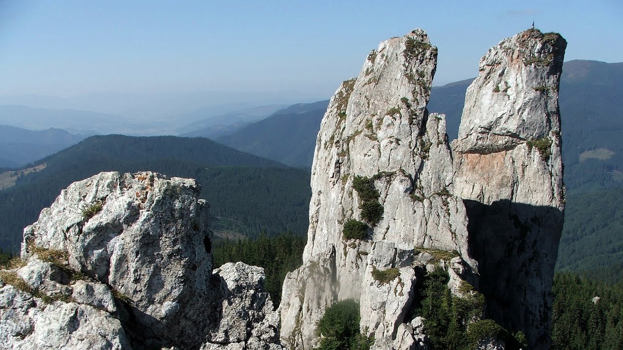
Lady's Stones - Rarau Mountains 0 km away
The Lady's Stones represent the heart, the mind, and the soul. The first two only help to understand the world when one possesses knowledge (they can be climbed with rock climbing gear), as emotions and thoughts (the two rock towers) obscure reality (the view).
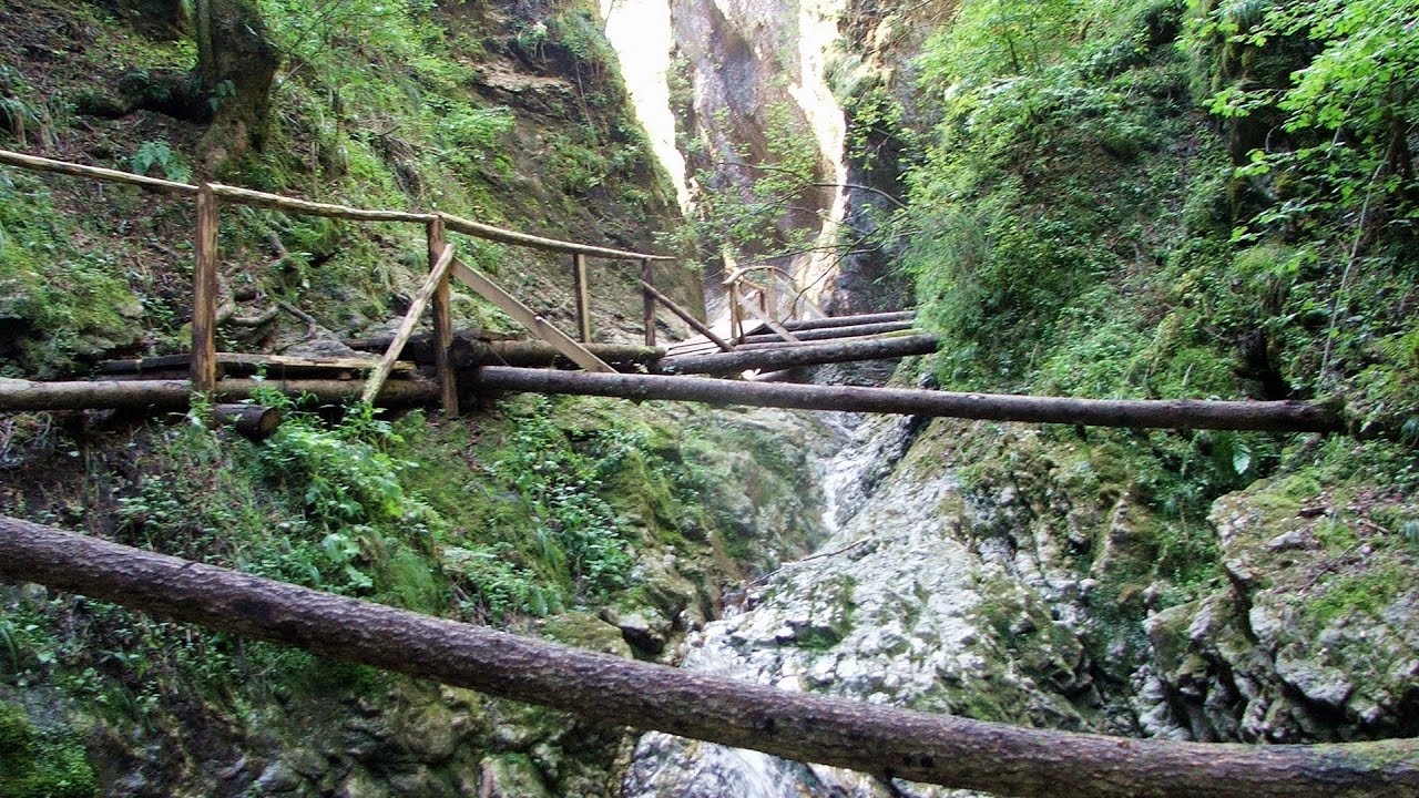
Devil's Mill Gorge - Campulung Moldovenesc 4.83 km away
The Devil's Mill Gorge is relatively short, measuring only 60 to 70 meters in length. It was formed in yellowish-gray-white dolomite by the work of a stream that crosses the gorge, as a result of erosion and the dissolution characteristic of limestone.

With snowshoes in the Tihu creek valley - Rastolita 51.76 km away
We met geotrekking treasure hunters from Gheorgheni, Miercurea Ciuc and Targu Mures in Rastolita. We entered the Calimani Mountains with an off-road vehicle, along the Rastolita and Tihu streams.

Via ferrata Bear Cave adventure and climbing zone - Borsec 53.53 km away
The Bear Cave in Borsec is a vast natural formation, scattered with rocks and deep crevices. Access to the cave's cavities is through a series of narrow formations resembling canyons, surrounded by giant fir trees and rocks with interesting shapes.

Astragalus iron path in winter - Glod Stone, Munticelu 72.35 km away
The official website of the Sugau Gorges published information about a new via ferrata climbing route named Astragalus. Sugau Gorges - Munticelu is a nature conservation area part of Natura 2000 located in Neamt County, which borders Harghita County.
Other places
Lednica iron path Brestnitsa 501 km away
The Lednica via ferrata is located next to the Saeva Dupka Cave, near the village of Brestnitsa in Bulgaria. The trail leading to the via ferrata, which opened in 2007, starts from the cave parking lot next to a covered resting area.
The Lednica via ferrata is located next to the Saeva Dupka Cave, near the village of Brestnitsa in Bulgaria. The trail leading to the via ferrata, which opened in 2007, starts from the cave parking lot next to a covered resting area.
Play Wall via ferrata park Mariazeller via ferrata, Felix's Ladder to the Heaven, Devil's Bridge 768.27 km away
Located only ten kilometers from the town of Mariazell, you'll find the via ferrata park known as the Play Wall (Klettersteigpark Spielmäuer). Here, we find three via ferratas: Olivers Mariazeller Steig (B/C), Felix Himmelleiter (D), and Tristans Kirchbogensteig (C).
Located only ten kilometers from the town of Mariazell, you'll find the via ferrata park known as the Play Wall (Klettersteigpark Spielmäuer). Here, we find three via ferratas: Olivers Mariazeller Steig (B/C), Felix Himmelleiter (D), and Tristans Kirchbogensteig (C).
Vulva cave Rhodope Mountains 638.95 km away
The Vulva Cave (Peshtera Utroba) is situated near the village of Nenkovo and the city of Kardzhali, in the Rhodope Mountains of Bulgaria. It derives its name from the shape of its entrance, which resembles a vulva.
The Vulva Cave (Peshtera Utroba) is situated near the village of Nenkovo and the city of Kardzhali, in the Rhodope Mountains of Bulgaria. It derives its name from the shape of its entrance, which resembles a vulva.
Sheepdogs Govora sheepfold Retezat mountains 301.53 km away
On the second day of my weekend Retezat hike, I visited a sheepfold on the Lancita Ridge. To my great disappointment, they didn't make cheese or curd here.
On the second day of my weekend Retezat hike, I visited a sheepfold on the Lancita Ridge. To my great disappointment, they didn't make cheese or curd here.
Borov Kamak waterfall Zgorigrad, Vratsa 503.91 km away
The Vratsa eco-trail starts from the village of Zgorigrad, located 6 km from the city of Vratsa in Bulgaria, and ends at the Parshevitza hut. It is also known as the Zgorigradska or Borov Kamak eco-trail.
The Vratsa eco-trail starts from the village of Zgorigrad, located 6 km from the city of Vratsa in Bulgaria, and ends at the Parshevitza hut. It is also known as the Zgorigradska or Borov Kamak eco-trail.
[ Top ↑ ]
[ Top ↑ ]
Copyright © 2003-2025 Trekkingklub and friends. Reproduction of any text, picture or video from this website, either in printed or electronic form, is prohibited without prior written permission. Nearby settlements: Chiril 5.6 km away, Tourist attractions Campulung Moldovenesc 9.21 km away. The given distances are to be understood as straight line distances, and are approximate. Website made in Miercurea Ciuc  .
.