Corbu Beach | Photos


Page no. 1, photos: 1-6, 54 photos in total. >>>

Copyright © 2007 - 2026 Trekkingklub.com. Please register for full and ad-free access.
Airport nearby: Mihail Kogălniceanu International Airport (CND - Mihail Kogălniceanu, Ro), 18 km away.
Photos of nearby places

Ezerets beach - Shabla, Dobrich (10 photos) 87.7 km away. The beach near the village of Ezerets is semi-wild, relatively quiet and clean, without sunbeds or umbrellas. The sand is fine-grained, and the water is clear.


Bird Observatory at Shabla Tuzla Lake (11 photos) 91.1 km away. Three coastal lakes - Shabla, Ezerets, and Shabla Tuzla - support a great variety of plants and animals. The lakes are especially important in winter, and they are protected to provide a refuge for their unique wildlife.

Fortress Kariya and the Lighthouse on Cape Shabla (13 photos) 93 km away. Shabla's lighthouse marks the easternmost point of Bulgaria. With its 32-meter height, it is the oldest and tallest lighthouse on the Black Sea.

Stone Sea and Little Sea beach - Shabla (10 photos) 95.3 km away. Monument of fallen Soviet aviators (May 17, 1944), Stone Sea and Little Sea beach - Shabla.

The coast of the Black Sea north of Tyulonovo (36 photos) 97.3 km away. The Portal, the Salt Pools, the Wild Frog's Point, the Seal Cave, the Passage and the Whale.

Fishermens harbor - Tyulenovo (14 photos) 98.3 km away. Tyulenovo church, Monument to Lieutenant Valentin Terziev, Fishermen's harbor. Tyulenovo translates to Village of Seals in Bulgarian, although seals have not been observed in the area since the 1980s.

Tyulenovo Cliffs and the Rock Arch (23 photos) 98.5 km away. The coast of Tyulenovo consists of a complex of sheer reefs, steep sea cliffs, and natural and artificial sea caves. There are picturesque beaches and rocky coasts, along with adjacent marine areas, both north and south of Tyulenovo.

The coast of the Black Sea south of Tyulenovo (10 photos) 99.1 km away. The coast of the Black Sea south of Tyulenovo.

The cave with the metal ladder - Tyulenovo (27 photos) 99.9 km away. The cave with the metal ladder (Peshterata s metalnata stalba) - Tyulenovo.

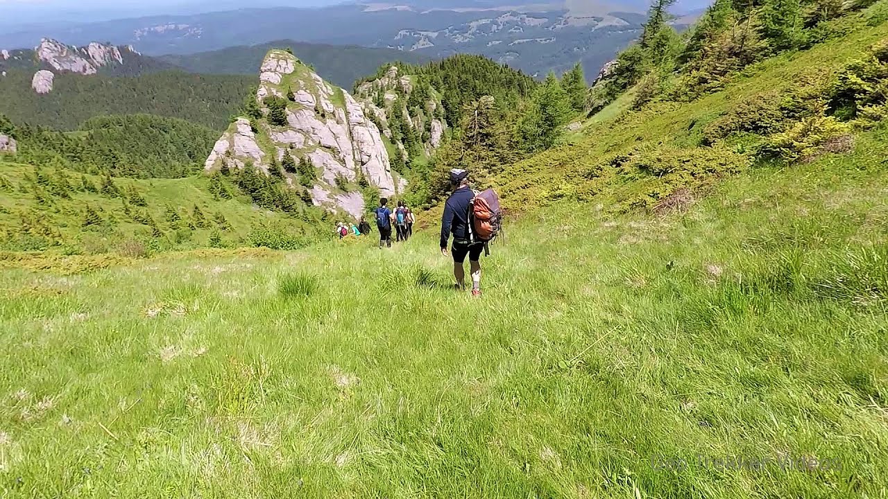
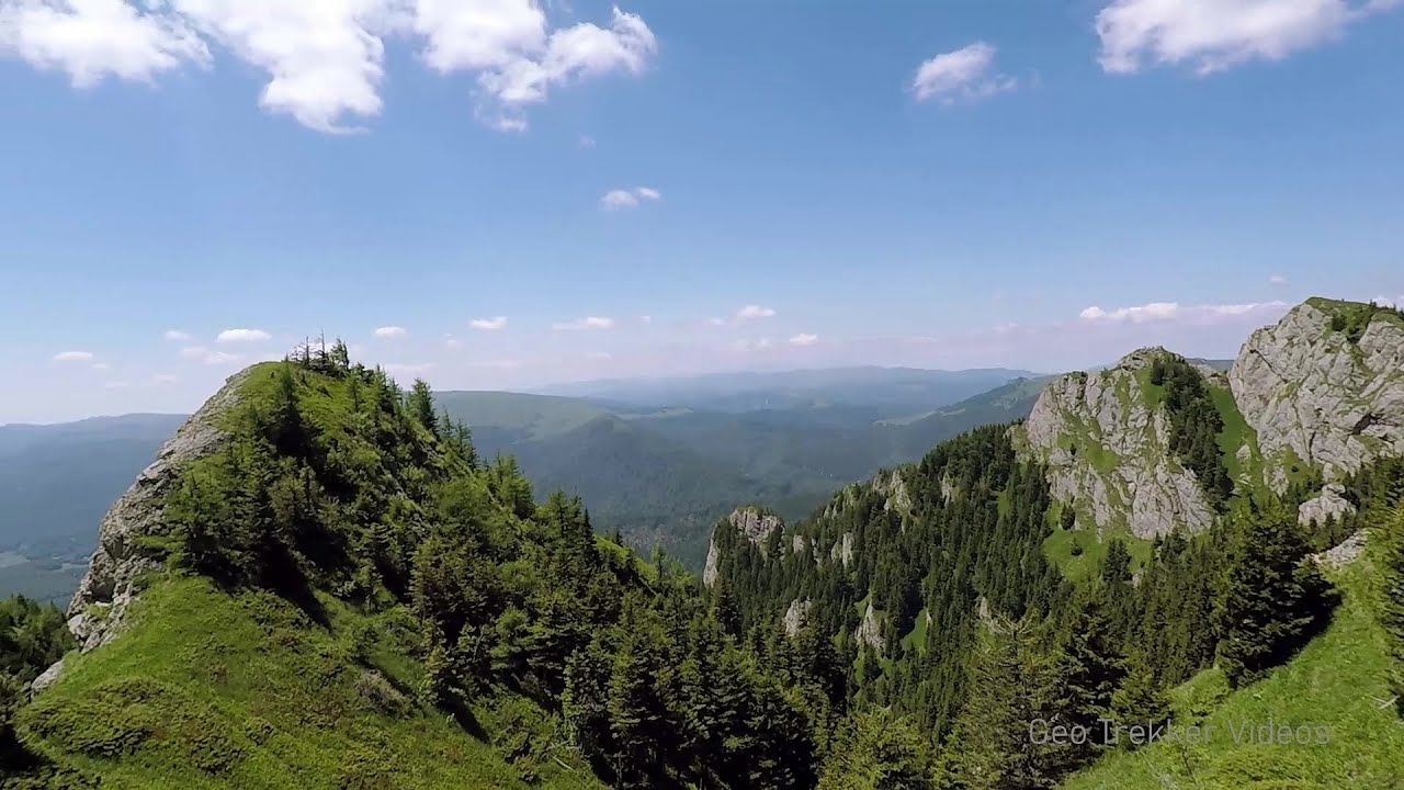
Pricopanului ridge - Macin Mountains (61 photos) 106.6 km away. Pricopanului ridge is the secondary, but imposing ridge of Macin Mountains, characterized by huge granite formations, lofty rocks and wide sceneries all around. The landscape, as well as the relief is of mountain type, and even if the height of the ridge is apparently small, the ascending effort is slighty sustained.

The Gate of the 40 Virgins (12 photos) 113.3 km away. The Gate of the 40 Virgins, The monument to Admiral Ushakov on Cape Kaliakra.
[ Top ↑ ]
Videos of nearby places

Stone Forest - Slanchevo 150.7 km away. The Stone Forest (Stones stuck in the ground, Pobiti Kamani) of Bulgaria is located 18 km west of Varna, at the foothills of the Eastern Balkan Mountains. Its Bulgarian name, Pobiti Kamani, translates to planted stones, and it is referred to in English as the Stone Desert or Stone Forest.

Cherven, a medieval fortified town - Bulgaria 230.5 km away. Located about 30 km south of the city of Ruse in Bulgaria, the Cherven medieval fortress can be found in the Rusenski Lom Nature Park. Originally a Byzantine fortification from the 6th century, it reached the height of its development in the 14th century.
Searching for rhododendrons - Ciucas Boulevard 249.2 km away. Red Mountain (Muntele Rosu), Gropsoarele-Zaganu ridge - Ciucas Mountains
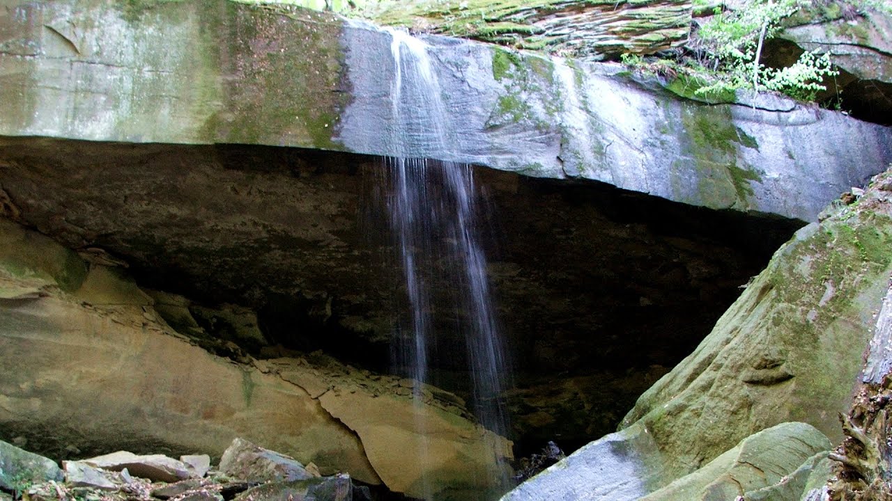
Waterfalls of Velnita stone-quarry - Targu Ocna 266.5 km away. Starting from the Velnita quarry, an adventurous nature enthusiast, accustomed to wild and rugged terrains, will discover a true waterfall paradise. At the upper part of the quarry, two streams converge.
Other places
Wild Ferenc iron path Suhardul Mic 352.3 km away. While I climbed the new iron path mostly in the dark for the first time, this time I managed to explore it during the day. But I still missed the sunset by a few minutes.
The Bears Jump iron path Baia de Fier 401.3 km away. The Bear's Jump (Saritoarea Ursului) is a fantasy-named via ferrata that opened in May 2018 near Baia de Fier, alongside the Middle Belt (Spirala Medie). Both routes begin from the G zone of the rock face that conceals the Women's Cave (Pestera Muierilor).
Lonely Stone Hasmas Mountains 341.2 km away. On June 1, 2003, with a small group of friends, I left Balan, walking along the valley of the Sep (Beautiful) stream towards the Lonely Stone (Piatra Singuratica). Those who were with me at the time fell behind, and then other people joined for the hike.
Kaya Bunar Hotnitsa 290.6 km away. The Kaya Bunar Waterfall (Hotnishki Vodopadi, Hotnitsa Waterfall) is located 20 km from the city of Veliko Tarnovo in Bulgaria. The waterfall is 30 meters high, and there are several smaller cascades above it.
Belogradchik fortress 489.6 km away. Belogradchik is located in the northwestern part of Bulgaria, in the Vidin Province, at the foot of the Balkan Mountains, near the Serbian border. Its name means little white town.
Haystack Rock Siculeni, Harghita Mountains 329.2 km away.
Snow-covered valley of Balea and the Transfagarasan in winter The ascent 351.7 km away. The Fagarasi Mountains can be easily approached from the north, mainly by using the Transfagarasan Road. This high altitude mountain road is only accessible during the summer months (throughout its entire length).
Via Ferrata Pink Panther Baia de Fier 401.2 km away. In the area of Baia de Fier in Gorj County, several via ferrata routes have been set up on the rock above the Women's Cave (Muierii Cave) and on the other side of the road. At that time (2018), there were a total of seven.
Transalpina Ski Resort Vidra lake 410.8 km away.
Ladys Stones Rarau Mountains 419.5 km away. The Lady's Stones represent the heart, the mind, and the soul. The first two only help to understand the world when one possesses knowledge (they can be climbed with rock climbing gear), as emotions and thoughts (the two rock towers) obscure reality (the view).
Big Via ferrata Rasnoavei Gorge 282.9 km away. The most dangerous Eastern European iron path, and also one of the most beautiful via ferrata routes in Romania, is in the Rasnoavei Gorges, Postavaru Mountains.The route is 450 m long, with a level difference of 220 m.
Huda lui Papara cave Salciua de Jos 466.5 km away. Huda lui Papara cave (Paparas Hole) - Salciua de Jos, Trascau Mountains.
Valla Canyon Observation Deck Küre Mountains National Park 461.1 km away. Situated within Küre Mountains National Park, the Valla canyon is one of the deepest in Turkey, with a depth of 800 meters. The 12 kilometer long canyon was formed by the Devrekani Stream, which cuts through the Küre Mountains.
Roman Baths Cetea, Trascau Mountains 453.8 km away. Roman Baths (Baile Romane) - Cetea, Trascau Mountains. Among the valleys of the Trascau Mountains, the Cetea Gorge best deserves the name of a crevice valley.
Devetashka cave Devetaki 332 km away. The Devetashka Cave is located in Bulgaria, near the village of Devetaki. After the entrance portal, which measures 30 m by 35 m, there is a vast open chamber that is 110 meters wide and 359 meters long.
Other destinations
Abandoned Sports Hall Varna 142 km away. An abandoned sports hall in Varna, with an unfinished dormitory and tennis courts across three levels.
[ Top ↑ ]
Copyright © 2003-2026 Trekkingklub and friends. Reproduction of any text, picture or video from this website, either in printed or electronic form, is prohibited without prior written permission.
The given distances are to be understood as straight line distances, and are approximate. Website made in Miercurea Ciuc  .
.