Varghis Gorge in winter | Photos


Page no. 1, photos: 1-6, 12 photos in total. >>>

Copyright © 2008 - 2026 Trekkingklub.com. Please register for full and ad-free access.
Airport nearby: Ghimbav International Airport (GHV - Brașov (Ghimbav), Ro), 57 km away.
Photos of nearby places


Harghita Bath - Harghita Mountains (15 photos) 19.6 km away. Harghita Bath (Harghita-Bai) - Harghita Mountains.
[ Top ↑ ]
Videos of nearby places
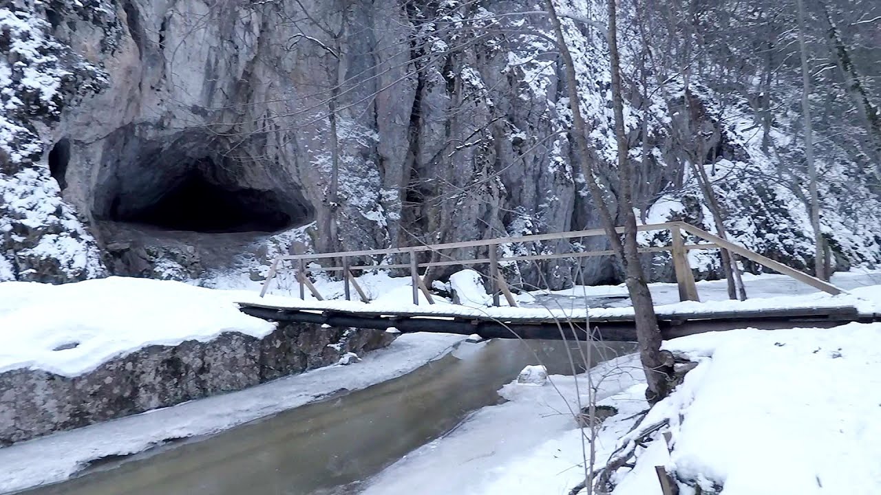
Varghis gorges in winter 0.1 km away. I went out to admire the ice stalagmites (standing icicles) in the Varghis Gorge. Anyone arriving here at the end of winter can observe meter-high ice stalagmites in the entrance area of Meresti Cave (now known as Orban Balazs Cave).

Kossuth Rock - Harghita Bath 20.4 km away. Kossuth Rock - Harghita Bath (Harghita-Bai), Harghita Mountains.

TV-radio amplifying station - Harghita Ciceu 20.6 km away. The hiking trail marked with a blue stripe starts at the Uz Bence shelter and runs from Harghita-Bai to Harghita Madaras. Our destination today is the Harghita Ciceu plateau.

Nobodys lake - Miercurea Ciuc 22.3 km away. The passage of time (time lapse), dusk at Nobody's Lake. Miercurea Ciuc and the Sumuleu mountain can be seen in the background.

Other places
Belintash Ridge of Dobrostan, Rhodope Mountains 488.3 km away. Belintash is a mysterious monolithic complex located approximately 50 km from Plovdiv, passing through the scenic Rhodope Mountains. It is situated southeast of the village of Vrata and west of the village of Sini Vruh.
Huda lui Papara cave Salciua de Jos 161 km away. Huda lui Papara cave (Paparas Hole) - Salciua de Jos, Trascau Mountains.
Blasted Rock hanging path Cerna Valley 267.9 km away. The Blasted Rock (Piatra Puscata) hanging path is located on the geographical right bank of the Cerna River, near the confluence of the Iuta stream, approximately 20 km from Baile Herculane. In this area, the presence of limestone formations has caused the valley to become narrower.
Clocota waterfall Geoagiu-Bai, Metaliferi Mountains 186 km away.
Transalpina Ski Resort Vidra lake 168.2 km away.
Krushuna waterfalls Krushuna 333.3 km away. The Krushuna Waterfalls are a series of karst cascades formed in travertine. They are located near the village of Krushuna, not far from the town of Lovech, and are Bulgaria's largest waterfall of this type.
Prohodna cave Karlukovo 357.9 km away. The Prohodna cave nicknamed The Eyes of God is located in Bulgaria, in the Iskar Gorge, on one of the largest karst areas in Bulgaria, 2 km from the town of Karlukovo. It is essentially a 262-meter-long natural stone bridge, with a large (45 m high) and a small (35 m high) entrance.
Kaya Bunar Hotnitsa 341.8 km away. The Kaya Bunar Waterfall (Hotnishki Vodopadi, Hotnitsa Waterfall) is located 20 km from the city of Veliko Tarnovo in Bulgaria. The waterfall is 30 meters high, and there are several smaller cascades above it.
Parmak Kaya Nochevo, Panichkovo 484.8 km away. Between the villages of Nochevo and Panichkovo in Chernoochene Municipality, Kardzhali Province, lies Parmak Kaya (Finger Rock). The site features ancient carvings and rock formations within an old pine forest.
Mine lake Megyer mountain, Sárospatak 382.3 km away. The via ferrata routes of the Megyer mountain mine lake. The geologists' path E 25 m, Szabó József-memorial path C 200 m, Amphitheater D 40 m, Devil's Cauldron E 70 m, Sweet aquatic life D 150 m, Velociraptor C 35 m.
The Wooden Ladders The villages of Scarisoara and Inelet, Cerna valley 268.7 km away. Scarisoara and Inelet are small, isolated villages located in the mountainous region of Banat. They are situated on the right bank of the Cerna River, approximately 19 km away from the Baile Herculane resort.
Laura iron path Baia de Fier 180 km away. Laura iron path (E) - Baia de Fier.
Turcinovac via ferrata and cave Ovcar Banja 492.3 km away. Difficulty level B, total length: 60 m, height difference: 45 m, year of construction: 2010. Climbing the via ferrata is only permitted with the approval of the Extreme Sports Club Armadillo from Cacak, and there is a fee for it.
Little Spiral via ferrata Baia de Fier 179.9 km away.
Stan Valley Canyon 119.5 km away. The Stan Valley is located near Lake Vidraru, southwest of it, in the Fruntii Mountains. Those who have visited the Seven Ladders Waterfall will appreciate this canyon, outfitted with infrastructure for tourist accessibility.
[ Top ↑ ]
Copyright © 2003-2026 Trekkingklub and friends. Reproduction of any text, picture or video from this website, either in printed or electronic form, is prohibited without prior written permission.
The given distances are to be understood as straight line distances, and are approximate. Website made in Miercurea Ciuc  .
.