Meresti cave - Varghis Gorge | Photos


Page no. 1, photos: 1-6, 18 photos in total. >>>

Copyright © 2004 - 2026 Trekkingklub.com. Please register for full and ad-free access.
Airport nearby: Ghimbav International Airport (GHV - Brașov (Ghimbav), Ro), 57 km away.
Photos of nearby places


Harghita Bath - Harghita Mountains (15 photos) 19.8 km away. Harghita Bath (Harghita-Bai) - Harghita Mountains.
[ Top ↑ ]
Videos of nearby places
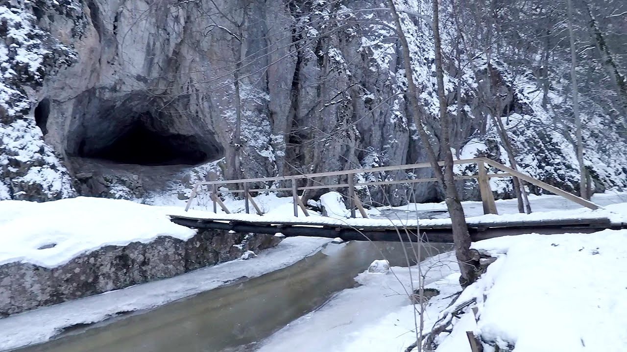
Varghis gorges in winter 0 km away. I went out to admire the ice stalagmites (standing icicles) in the Varghis Gorge. Anyone arriving here at the end of winter can observe meter-high ice stalagmites in the entrance area of Meresti Cave (now known as Orban Balazs Cave).

Kossuth Rock - Harghita Bath 20.5 km away. Kossuth Rock - Harghita Bath (Harghita-Bai), Harghita Mountains.

TV-radio amplifying station - Harghita Ciceu 20.7 km away. The hiking trail marked with a blue stripe starts at the Uz Bence shelter and runs from Harghita-Bai to Harghita Madaras. Our destination today is the Harghita Ciceu plateau.

Nobodys lake - Miercurea Ciuc 22.4 km away. The passage of time (time lapse), dusk at Nobody's Lake. Miercurea Ciuc and the Sumuleu mountain can be seen in the background.

Other places
Virus and Antivirus iron paths Baia de Fier 179.9 km away. With Virus (B/C) and Antivirus (C), the number of via ferrata routes at Baia de Fier has increased to thirteen. In fact, it is a Y-shaped route that starts near the entrance of the Laura via ferrata, and the exits are located just a few meters from the Laura exit.
Prohodna cave Karlukovo 357.8 km away. The Prohodna cave nicknamed The Eyes of God is located in Bulgaria, in the Iskar Gorge, on one of the largest karst areas in Bulgaria, 2 km from the town of Karlukovo. It is essentially a 262-meter-long natural stone bridge, with a large (45 m high) and a small (35 m high) entrance.
The two niches with the visor Nochevo 483.3 km away. Dvete nishi s kozirkata (The two niches with the visor) - Nochevo.
Turcinovac via ferrata and cave Ovcar Banja 492.2 km away. Difficulty level B, total length: 60 m, height difference: 45 m, year of construction: 2010. Climbing the via ferrata is only permitted with the approval of the Extreme Sports Club Armadillo from Cacak, and there is a fee for it.
Ramet Gorge Goagiu Creek 159.7 km away. Ramet Gorge (Cheile Rametului) - Goagiu Creek (Paraul Goagiu), Trascau Mountains. The Ramet Gorge is the wildest canyon in the Trascau Mountains.
Buzludzha monument Kazanluk 387.4 km away. Buzludzha is a historically significant mountain located in the Central Balkan Mountains of Bulgaria. At its summit, at an altitude of 1432 meters above sea level, there is an abandoned monument.
Byala Reka eco-trail Kalofer 398.6 km away. The Byala Reka eco-trail is situated at the foot of the Stara Planina mountain range, 8 km from the town of Kalofer. A 1,830-meter-long hiking trail has been established along the White Creek within the Central Balkan National Park.
Laura iron path Baia de Fier 179.9 km away. Laura iron path (E) - Baia de Fier.
Hodoaba Valley iron path Suncuius 242.4 km away. The Hodoaba Valley iron path is Romania's shortest and easiest (official) via ferrata route. It is located near Suncuius, in the Padurea Craiului Mountains, on the left bank of the Crisul Repede River.
Shipka pass Shipka 386.3 km away. The Shipka Pass is one of the most spectacular crossings of the Balkan Mountains, and is part of the Bulgarka Nature Park. It separates the provinces of Gabrovo and Stara Zagora, and provides a connection between the cities of Gabrovo and Kazanlak.
Roman Baths Cetea, Trascau Mountains 153.2 km away. Roman Baths (Baile Romane) - Cetea, Trascau Mountains. Among the valleys of the Trascau Mountains, the Cetea Gorge best deserves the name of a crevice valley.
Belogradchik fortress 366.3 km away. Belogradchik is located in the northwestern part of Bulgaria, in the Vidin Province, at the foot of the Balkan Mountains, near the Serbian border. Its name means little white town.
The Wooden Ladders The villages of Scarisoara and Inelet, Cerna valley 268.7 km away. Scarisoara and Inelet are small, isolated villages located in the mountainous region of Banat. They are situated on the right bank of the Cerna River, approximately 19 km away from the Baile Herculane resort.
Iskar gorge Lyutibrod Temnata dupka cave Lakatnik 387.6 km away. The Iskar is the longest purely Bulgarian river, the oldest river in the Balkans, and a right tributary of the Danube. The river is 368 km long, with approximately 150 km consisting of a gorge.
Little Spiral via ferrata Baia de Fier 179.8 km away.
[ Top ↑ ]
Copyright © 2003-2026 Trekkingklub and friends. Reproduction of any text, picture or video from this website, either in printed or electronic form, is prohibited without prior written permission.
The given distances are to be understood as straight line distances, and are approximate. Website made in Miercurea Ciuc  .
.