Tower of King Rock - Piatra Craiului Mountains | Photos


Page no. 1, photos: 1-6, 15 photos in total. >>>

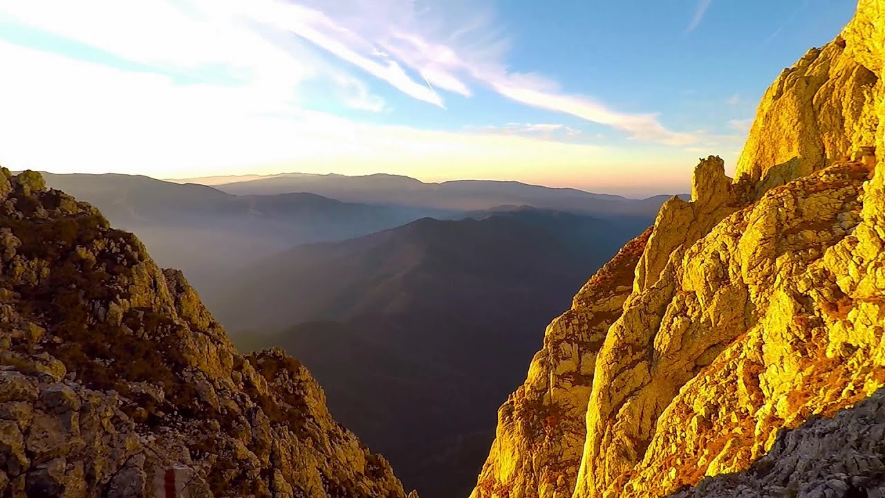
Border Ravine Valley (Padina Hotarului), Turm des Königstein (Turnul Pietrei Craiului).
Copyright © 2005 - 2026 Trekkingklub.com. Please register for full and ad-free access.
Airport nearby: Ghimbav International Airport (GHV - Brașov (Ghimbav), Ro), 27 km away.
Photos of nearby places

The Cats Gorge - Curmatura Cabin (20 photos) 0.8 km away. The Cat's Gorge - Valley of the Gorge Stream - Curmatura Cabin - Rift Saddle.

Little King Rock - Piatra Craiului Mountains (14 photos) 1.2 km away. Little King Rock (Piatra Mica) - Piatra Craiului Mountains (King Rock).

Border Ravine Valley, Northern ridge (53 photos) 2.4 km away. Border Ravine Valley (Padina Hotarului), Northern ridge - Piatra Craiului Mountains (King Rock).

Northern ridge - Piatra Craiului (11 photos) 2.4 km away. Northern ridge - Piatra Craiului Mountains (King Rock).

Middle Belt Trail - Piatra Craiului Mountains (114 photos) 3.3 km away. Ravine valley of Calinet (Padina lui Calinet) - Thermopylae - Anghelide's canyon, Piatra Craiului Mountains (King Rock).

Zarnesti precipice - Piatra Craiului Mountains (16 photos) 4.2 km away. Zarnesti precipice (Prapastiile Zarnestilor) - Piatra Craiului Mountains (King Rock).

Zarnesti Gorge - Piatra Craiului Mountains (6 photos) 4.2 km away. Zarnesti Gorge (Prapastiile Zarnestilor) - Piatra Craiului Mountains.

Deubels path - Piatra Craiului Mountains (36 photos) 5.1 km away. Plaiul Foii - Deubel cavities (La Zaplaz) - Grind saddle. Deubel's path - Piatra Craiului Mountains (King Rock).

The shoulder of Piatra Craiului Mountains (36 photos) 5.8 km away. The shoulder of Piatra Craiului Mountains (King Rock's Shoulder).

Southern ridge - Piatra Craiului Mountains (42 photos) 6.1 km away. Southern ridge - Piatra Craiului Mountains (King Rock).

Cave of Stanciu - Piatra Craiului Mountains (10 photos) 7.1 km away. Cave of Stanciu (Pestera Stanciului) - Piatra Craiului Mountains (King Rock).

Stanciu rock porch - Piatra Craiului Mountains (18 photos) 7.1 km away. Stancius rock porch (Ceardacul Stanciului) - Piatra Craiului Mountains (King Rock).
[ Top ↑ ]
Videos of nearby places
Deubels path - Piatra Craiului Mountains 5.1 km away. Deubels path - Piatra Craiului Mountains (Kings Rock).

Dino Parc Rasnov 17.7 km away. On June 12, 2015, one of the largest dinosaur theme parks in the region opened in Rasnov, where we can see 45 life-sized dinosaurs. The facility is located directly next to the Rasnov Fortress, which is one of the best-preserved Transylvanian Saxon peasant fortresses.

Small Via ferrata - Rasnoavei Gorge 20.7 km away. In the past few days, it has snowed, so I climbed the two climbing routes in the Rasnoavei Gorge under winter conditions. While the lower part of the challenging Big via ferrata was dry, the upper section had patches of snow and icicles.

Big Via ferrata Rasnoavei Gorge 20.8 km away. The most dangerous Eastern European iron path, and also one of the most beautiful via ferrata routes in Romania, is in the Rasnoavei Gorges, Postavaru Mountains.The route is 450 m long, with a level difference of 220 m.

Ski resort - Poiana Brasov - Postavarul Mountains 23.6 km away. Shining sun and an Austria-feeling on the impeccable slopes of the ski paradise Poiana Brasov above Brasov. Sunbathing, coffee and refreshing drinks on the terrace of Julius Römer chalet.
Other places
Lonely Stone Hasmas Mountains 132.9 km away. On June 1, 2003, with a small group of friends, I left Balan, walking along the valley of the Sep (Beautiful) stream towards the Lonely Stone (Piatra Singuratica). Those who were with me at the time fell behind, and then other people joined for the hike.
Babsko Praskalo waterfall Tazha 317.6 km away. In the Central Balkans National Park, there are many rivers that cascade down spectacular waterfalls, which the locals call praskalo. One of the smallest waterfalls in the area is Babsko Praskalo, which stands at only 54 meters high.
Boli Cave Banita 151.1 km away. The Boli Cave is located 6 km north of Petrosani, on the road that connects Hateg with the Jiu Valley. Here, the railway line that connects the two parts of Hunedoara County passes through, featuring a total of 66 curves and 8 tunnels.
The Amphitheater of the Dragons Baia de Fier 123.8 km away. The Amphitheater of the Dragons (Amfiteatrul Zmeilor) is the seventh (2017) via ferrata route in Baia de Fier. It was inaugurated last year, on December 26, 2017, after Christmas.
Bicajel Gorge Hasmas Mountains 146.1 km away. Bicajel Gorge (Cheile Bicajelului) - Hasmas Mountains.
Ramet Gorge Goagiu Creek 160.3 km away. Ramet Gorge (Cheile Rametului) - Goagiu Creek (Paraul Goagiu), Trascau Mountains. The Ramet Gorge is the wildest canyon in the Trascau Mountains.
Huda lui Papara cave Salciua de Jos 165.9 km away. Huda lui Papara cave (Paparas Hole) - Salciua de Jos, Trascau Mountains.
Womens Spiral, Cave Ridge, and The Great Crack iron paths Baia de Fier 123.8 km away. Perhaps the most interesting via ferrata among the routes in the Baia de Fier area is the Womens Spiral. After completing it, I can say that it is the second most thrilling via ferrata in Romania, following the Big Via Ferrata at Rasnov.
Kaya Bunar Hotnitsa 268.9 km away. The Kaya Bunar Waterfall (Hotnishki Vodopadi, Hotnitsa Waterfall) is located 20 km from the city of Veliko Tarnovo in Bulgaria. The waterfall is 30 meters high, and there are several smaller cascades above it.
Corcoaia Gorge Gorj county 205.4 km away. The Corcoaia Gorge is one of the most beautiful tourist attractions in the Cerna Valley. It can be reached by car, 43 km away from Baile Herculane, of which about 17 km is on a dusty gravel road.
Billy-goat lake, Closed Gates Retezat Mountains 182.6 km away. The most unique ridge trail of the Retezat Mountains is the Closed Gates.Below, at an altitude of 2070 m above sea level, is the Billy-goat lake.
Borov Kamak waterfall Zgorigrad, Vratsa 301.3 km away. The Vratsa eco-trail starts from the village of Zgorigrad, located 6 km from the city of Vratsa in Bulgaria, and ends at the Parshevitza hut. It is also known as the Zgorigradska or Borov Kamak eco-trail.
Via ferrata Bear Cave adventure and climbing zone Borsec 158.5 km away. The Bear Cave in Borsec is a vast natural formation, scattered with rocks and deep crevices. Access to the cave's cavities is through a series of narrow formations resembling canyons, surrounded by giant fir trees and rocks with interesting shapes.
Gods bridge Vratsa 283.4 km away. Anyone who has been to Bulgaria may be familiar with the Prohodna Cave, affectionately known as the Eyes of God; the Devetashka Cave, illuminated by seven windows in its ceiling. And perhaps they have also seen the Wonderful Bridges in the Rhodope Mountains.
[ Top ↑ ]
Copyright © 2003-2026 Trekkingklub and friends. Reproduction of any text, picture or video from this website, either in printed or electronic form, is prohibited without prior written permission.
The given distances are to be understood as straight line distances, and are approximate. Website made in Miercurea Ciuc  .
.