The Cats Gorge - Curmatura Cabin | Photos


Page no. 1, photos: 1-6, 20 photos in total. >>>

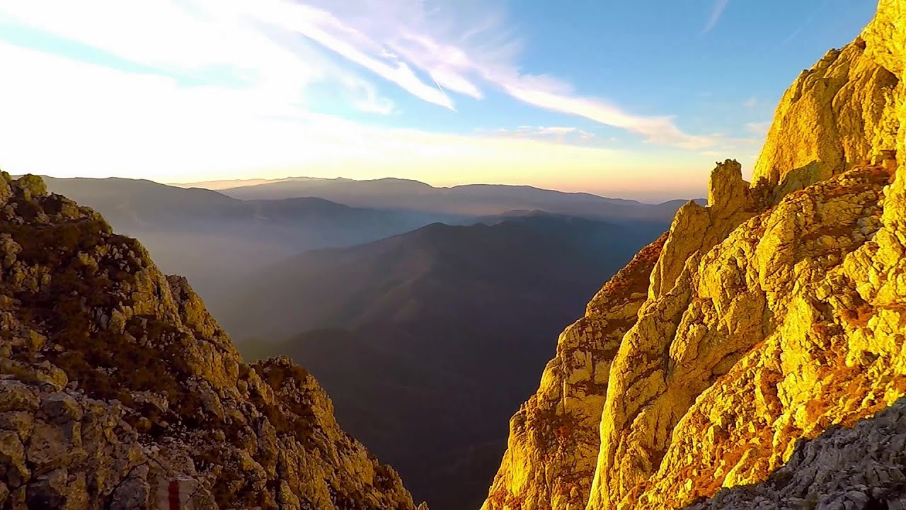
The Cat's Gorge - Valley of the Gorge Stream - Curmatura Cabin - Rift Saddle.
Copyright © 2013 - 2026 Trekkingklub.com. Please register for full and ad-free access.
Airport nearby: Ghimbav International Airport (GHV - Brașov (Ghimbav), Ro), 27 km away.
Photos of nearby places

Little King Rock - Piatra Craiului Mountains (14 photos) 0.8 km away. Little King Rock (Piatra Mica) - Piatra Craiului Mountains (King Rock).

Tower of King Rock - Piatra Craiului Mountains (15 photos) 0.8 km away. Border Ravine Valley (Padina Hotarului), Turm des Königstein (Turnul Pietrei Craiului).

Border Ravine Valley, Northern ridge (53 photos) 2.3 km away. Border Ravine Valley (Padina Hotarului), Northern ridge - Piatra Craiului Mountains (King Rock).

Northern ridge - Piatra Craiului (11 photos) 2.3 km away. Northern ridge - Piatra Craiului Mountains (King Rock).

Middle Belt Trail - Piatra Craiului Mountains (114 photos) 3.2 km away. Ravine valley of Calinet (Padina lui Calinet) - Thermopylae - Anghelide's canyon, Piatra Craiului Mountains (King Rock).

Zarnesti precipice - Piatra Craiului Mountains (16 photos) 3.4 km away. Zarnesti precipice (Prapastiile Zarnestilor) - Piatra Craiului Mountains (King Rock).

Zarnesti Gorge - Piatra Craiului Mountains (6 photos) 3.4 km away. Zarnesti Gorge (Prapastiile Zarnestilor) - Piatra Craiului Mountains.

Deubels path - Piatra Craiului Mountains (36 photos) 4.8 km away. Plaiul Foii - Deubel cavities (La Zaplaz) - Grind saddle. Deubel's path - Piatra Craiului Mountains (King Rock).

The shoulder of Piatra Craiului Mountains (36 photos) 5.6 km away. The shoulder of Piatra Craiului Mountains (King Rock's Shoulder).

Southern ridge - Piatra Craiului Mountains (42 photos) 5.7 km away. Southern ridge - Piatra Craiului Mountains (King Rock).

Cave of Stanciu - Piatra Craiului Mountains (10 photos) 6.7 km away. Cave of Stanciu (Pestera Stanciului) - Piatra Craiului Mountains (King Rock).

Stanciu rock porch - Piatra Craiului Mountains (18 photos) 6.8 km away. Stancius rock porch (Ceardacul Stanciului) - Piatra Craiului Mountains (King Rock).
[ Top ↑ ]
Videos of nearby places
Deubels path - Piatra Craiului Mountains 4.8 km away. Deubels path - Piatra Craiului Mountains (Kings Rock).

Dino Parc Rasnov 17.6 km away. On June 12, 2015, one of the largest dinosaur theme parks in the region opened in Rasnov, where we can see 45 life-sized dinosaurs. The facility is located directly next to the Rasnov Fortress, which is one of the best-preserved Transylvanian Saxon peasant fortresses.

Small Via ferrata - Rasnoavei Gorge 20.4 km away. In the past few days, it has snowed, so I climbed the two climbing routes in the Rasnoavei Gorge under winter conditions. While the lower part of the challenging Big via ferrata was dry, the upper section had patches of snow and icicles.

Big Via ferrata Rasnoavei Gorge 20.5 km away. The most dangerous Eastern European iron path, and also one of the most beautiful via ferrata routes in Romania, is in the Rasnoavei Gorges, Postavaru Mountains.The route is 450 m long, with a level difference of 220 m.

Ski resort - Poiana Brasov - Postavarul Mountains 23.4 km away. Shining sun and an Austria-feeling on the impeccable slopes of the ski paradise Poiana Brasov above Brasov. Sunbathing, coffee and refreshing drinks on the terrace of Julius Römer chalet.
Other places
Hodoaba Valley iron path Suncuius 258.8 km away. The Hodoaba Valley iron path is Romania's shortest and easiest (official) via ferrata route. It is located near Suncuius, in the Padurea Craiului Mountains, on the left bank of the Crisul Repede River.
Sugau Stone lookout point and iron path, Sugau Gorge Munticelu 149.2 km away. Sugau Stone lookout point and iron path (B/C), Sugau Gorge - Munticelu Nature Reserve.
Suspension bridge Aries river, Salciua de Sus 174.3 km away.
Giant fir trees Ghimes 134 km away. One of the lesser-known attractions of Ghimes is the two giant-sized common fir trees. They are 42 meters tall, and have diameters of 110 cm and 130 cm at chest height.
Ramet Gorge Goagiu Creek 160.9 km away. Ramet Gorge (Cheile Rametului) - Goagiu Creek (Paraul Goagiu), Trascau Mountains. The Ramet Gorge is the wildest canyon in the Trascau Mountains.
Stone Beach Sinemorets 450 km away. Stone Beach (Kamenniat plazh) - Sinemorets.
Falco Peregrinus via ferrata Falcons Rock, Corbu 167 km away. Falco Peregrinus (Peregrine falcon) via ferrata (B/C) - Falcon's Rock, Corbu.
Sugau Rock lookout point and iron path 149.2 km away. Sugau Rock lookout point and iron path (B/C). Sugau Gorges - Munticelu Nature Reserve, Hasmas Mountains.
Bicajel Gorge Hasmas Mountains 146.8 km away. Bicajel Gorge (Cheile Bicajelului) - Hasmas Mountains.
The Stone Wedding Zimzelen, Kardzhali 433.1 km away. The Stone Wedding (Kamenna Svatba, Petrified Wedding, Kardzhali Pyramids) is located near the village of Zimzelen, close to the city of Kardzhali, in the eastern part of the Rhodope Mountains in Bulgaria. This spectacular natural formation was declared a natural monument in 1974.
Sumuleu-Ciuc in winter 102.1 km away. Sumuleu-Ciuc (Csíksomlyó) in winter.
Roman Baths Cetea, Trascau Mountains 152.9 km away. Roman Baths (Baile Romane) - Cetea, Trascau Mountains. Among the valleys of the Trascau Mountains, the Cetea Gorge best deserves the name of a crevice valley.
Shiroka Laka village Smolyan 433.9 km away. Shiroka Laka is one of the most beautiful villages in Bulgaria. It is located in the Rhodope Mountains, in the Smolyan province, in the southern part of the country.
Abandoned Sports Hall Varna 336.8 km away. An abandoned sports hall in Varna, with an unfinished dormitory and tennis courts across three levels.
Pricske peak Giurgeu Mountains 141.1 km away. If we want to reach Pricske (Prisca) peak, which rises above Gheorgheni and Lazarea, we start from the valley of the Güdüc (Ghidut) stream. Our path leads us past the ruins of a building known as the White House.
[ Top ↑ ]
Copyright © 2003-2026 Trekkingklub and friends. Reproduction of any text, picture or video from this website, either in printed or electronic form, is prohibited without prior written permission.
The given distances are to be understood as straight line distances, and are approximate. Website made in Miercurea Ciuc  .
.